Good morning. This is Eric Knoff with the Gallatin National Forest Avalanche Advisory issued on Saturday, March 5, at 7:30 a.m. Cliff Gullet Memorial Fund, in cooperation with the Friends of the Avalanche Center, sponsors today’s advisory. This advisory does not apply to operating ski areas.
Over the past 24 hours a trace to one inch of new snow has fallen over the mountains of our advisory area. Currently, winds are blowing 15-30 mph out of the WSW and temperatures are in the mid teens to low 20s F. Today, winds will gradually increase out of the WSW with ridgetop gusts reaching close to 40 mph. Temperatures will rise into the mid 20s to low 30s F under cloudy skies. An approaching storm will impact our area by late afternoon producing light mountain snow showers. 2-4 inches of snow will likely accumulate in most areas by tomorrow morning with the exception of Cooke City which will likely pick up 4-6 inches.
The Bridger, Madison and Gallatin Ranges, the Lionhead area near West Yellowstone, the mountains around Cooke City and the Washburn Range:
Avalanche activity seems to have taken an early spring break. I spoke with multiple parties who ventured into the backcountry yesterday; all had a similar response - it's pretty quiet out there. Warm and calm conditions over the past 24 hours have likely reduced any avalanche threat from the snow that fell Thursday night. Yesterday, Mark logged in the miles in the Taylor Fork hunting for lingering instability; in four different snowpits he found stable dense snow. This seems to be a theme throughout our advisory area.
If stable conditions have you seeking adventure in steep consequential terrain, there are few things to keep in mind. Moderate westerly winds over the past few days have produced small wind drifts on leeward aspects. The most likely areas to find pockets of windblown snow will be on upper elevation slopes, especially slopes with an easterly component. Pockets of windblown snow likely have bonded well to the old snow surface, but triggering a small wind slab will not be impossible. Paying close attention to the consequences of triggering a slide is important. Even a small side has the potential to carry you into trees, rocks, gullies or over cliffs.
Although generally stable conditions exist; the avalanche danger could potentially increase throughout the day with an early arrival of snow and wind. Always be cognizant of the current weather and the effects it is having on your surroundings.
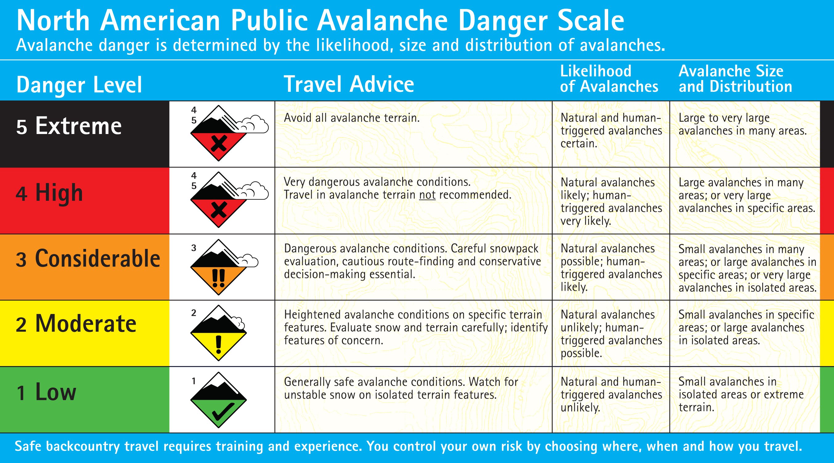
For today, generally safe avalanche conditions exist and the avalanche danger is rated LOW.
Click here for the most current North American Public Avalanche Danger Scale.
I will issue the next advisory tomorrow morning at 7:30 a.m. If you have any snowpack or avalanche observations, drop us a line at mtavalanche@gmail.com or call us at 587-6984.
PHOTOS, SNOWPITS, VIDEO and SURVEY RESULTS
1. We’ve recently uploaded more photos and snowpits to our web site.
2. We’re creating a series of “How To…” stability test videos. So far we’ve made clips on performing a CT and ECT. There are located under <Stability Tests> on the Resources page.
3. The results from our survey are posted online. Thanks to all who participated. You can check out the results at http://bit.ly/fpLuSi.
Upcoming Events
Today: Pinhead Classic
The 30th Annual Pinhead Classic is today. “Gangsters and Flappers” is this year’s costume theme, so come dressed up to race, socialize and win great prizes. Registration is $30 and gets you course entry, t-shirt, pint glass, beverages, dinner, and dancing. All proceeds benefit the Friends of the Avalanche Center. Check out the website http://pinheadclassic.com for details. Normal 0 false false false EN-US X-NONE X-NONE /* Style Definitions */ table.MsoNormalTable {mso-style-name:"Table Normal"; mso-tstyle-rowband-size:0; mso-tstyle-colband-size:0; mso-style-noshow:yes; mso-style-priority:99; mso-style-qformat:yes; mso-style-parent:""; mso-padding-alt:0in 5.4pt 0in 5.4pt; mso-para-margin:0in; mso-para-margin-bottom:.0001pt; mso-pagination:widow-orphan; font-size:10.0pt; font-family:"Times New Roman","serif";}
The