Good morning. This is Ian Hoyer with the Gallatin National Forest Avalanche Forecast on Friday, December 9th at 7:00 a.m. This information is sponsored by Yellowstone Ski Tours,Klim and Bridger Bowl. This forecast does not apply to operating ski areas.
Please consider donating to the Friends of GNFAC Annual Fundraiser.
One inch of new snow fell around West Yellowstone yesterday, while the rest of the area remained dry. Temperatures this morning are in the single digits to mid-teens F with 10 to 25 mph winds from the south and west gusting 35-45 mph. Today, temperatures will rise to the upper teens to mid 20s F with moderate south and west winds continuing. Snowfall will begin this morning with 1-3 inches falling around Bozeman and 2-4 inches across the rest of the advisory area by this evening. Another round of snow is forecast to start tomorrow afternoon, again favoring the southern areas.

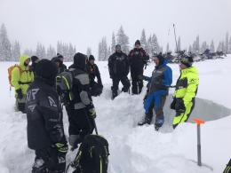
There is weak snow buried 2-3 ft deep that could avalanche under the weight of a skier or rider today (Taylor Fork video). Several natural slides broke on these layers during the loading event early in the week and on Tuesday a rider triggered a large slide near Daisy Pass (Daisy Pass video, Taylor Fork details, Henderson photo and details). The snowpack has now had a few days to accommodate the stress of new and wind drifted snow. Natural avalanches have become unlikely, but human triggered slides remain possible. Dig to search for and test these weak layers in the middle of the snowpack before riding steep slopes. Be doubly skeptical of the weak layers if they are sitting beneath hard slabs of wind drifted snow. Also watch for thin fresh drifts forming today as new snow accumulates.
The avalanche danger is MODERATE.
In the mountains around Bozeman and Big Sky, the primary avalanche concern is slides breaking in drifts of wind-blown snow.
Yesterday, the Yellowstone Club Ski Patrol saw two small avalanches on wind drifted slopes on Cedar Mountain that broke naturally sometime in the last few days (detail and photos). On Monday, two skiers were carried 600 ft by an avalanche that initially broke only 6 inches deep as they ascended a couloir on Ross Peak (details and photos). They ended up partially buried with snow packed into the mouth of one skier. This is a good reminder of the power of even a shallow slab.
Watch out for and avoid these wind drifts, or carefully check to see how they’ve bonded before riding steep slopes. We also can’t yet rule out the possibility that there are weak layers on some slopes. Dig and look for weak layers hiding 1-2 ft deep. If you find them, retreat to lower angled terrain and send in an observation to let us know where you found them.
Human-triggered avalanches are possible and the danger is rated MODERATE today
If you get out, please share avalanche, snowpack or weather observations via our website, email (mtavalanche@gmail.com), phone (406-587-6984), or Instagram (#gnfacobs)

4-8” of new snow are possible in the Island Park area during the day today. There is weak snow buried 2-3 ft deep in the Lionhead area (and it likely exists in the Island Park area as well) that could avalanche under the weight of a skier or rider today. Dig to search for and test these weak layers in the middle of the snowpack before riding steep slopes. Also watch for fresh drifts forming today as new snow accumulates, if it’s drifted more than a few inches deep you could trigger a dangerous slide.
Dave and I are headed to the Island Park area today. Visit the Island Park Trip Planning page tonight to learn what we find, and watch our field video.
Upcoming Avalanche Education and Events
Our education calendar is full of awareness lectures and field courses. Check it out: Events and Education Calendar.
Monday, December 12, 5-8 p.m. @MAP Brewing, Movie Night.
Tuesday, December 13, 6 p.m., Avalanche Awareness + Beacons at Story Mill Park. Free.
Watch our playlist of YouTube videos to get caught up on our avalanche concerns this season.