Good morning. This is Doug Chabot with the Gallatin National Forest Avalanche Forecast on Wednesday, January 25th at 7:00 a.m. Today’s forecast is sponsored by Highline Partners and Cooke City Super 8/Bearclaw Bob’s. This forecast does not apply to operating ski areas.
Since 5 a.m. yesterday the mountains around Big Sky got 8” of powder, the mountains around Bozeman and Cooke City got 5-6”, and the southern ranges including West Yellowstone got 1-2”. Yesterday was windy in the northern mountains with gusts in the 40’s from the northwest. Wind lessened overnight to 15-30 mph out of the west to northwest. Temperatures are 10F and will rise to 20F as west to north wind blows 15-30 mph. Snowfall later this afternoon and tonight will drop 3-5” around Bozeman, Big Sky and Cooke City and 1-3” elsewhere.

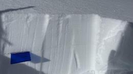
Yesterday was windy in the mountains around Bozeman. Gusts of 40+ mph from the northwest blew old and new snow around. Today's wind and new snow (5-6” of 5% density, aka. powder) will continue to build drifts and create dangerous avalanche conditions. Yesterday, an ice climber reported a large natural avalanche running over a popular west-facing ice climb (Silken Falls) in Hyalite. The gully above the climb was wind-loaded. I expect to see more avalanches on wind-loaded terrain today. Gullies, open slopes near the ridgelines, or any place the snow can drift are all unstable. Weak, faceted snow, like what we found on Mount Ellis yesterday (video) and the Bridgers on Saturday (Saddle Peak) and Sunday (Playground) is being taxed beyond its holding power on wind-drifted slopes.
For today, the avalanche danger is rated CONSIDERABLE on wind-drifted slopes and MODERATE on those protected by the wind.
The mountains around Big Sky and Cooke City are lumped together because they have a similar weak layer and similar snowfall amounts. They each received .3” of snow water equivalent (SWE) measuring 8” of snow around Big Sky and an estimated 6” in Cooke City. On some slopes, buried 1-2 feet under the surface, is a layer of feathery surface hoar that has potential to avalanche (observation). Winds are building thick drifts and the surface hoar layer is likely to be triggered by skiers or sledders. On slopes without wind drifting, .3” of SWE is not heavy enough to spike the instability on deeper layers of sugary facets near the ground. However, slopes or gullies with wind-drifting are another story and should be avoided.
For today, the avalanche danger is rated CONSIDERABLE on wind-drifted slopes and MODERATE on all others.

The mountains south of Big Sky to West Yellowstone received 1-2” of snowfall (.1-.2” of SWE). The snowpack has 2 buried weak layers: feathery crystals of surface hoar 6” to 2 feet deep, and sugary facets near the ground. Dave was in Bacon Rind on Monday and found them both collapsing and shearing in his snowpit (video) which caused him enough concern that he and his partner descended a less steep line than they intended. Dave and I found this layer in Lionhead last week (video) and on Monday riders around Two Top uncovered 3 stripes of surface hoar in their snow pit and decided to stay out of avalanche terrain (observation). Dig and look for this weak layer. If you find it, avoid slopes steeper than 30-degrees (avalanche terrain). If you don’t find it, dig again, and maybe even again before committing to a slope.
Today, human-triggered avalanches are possible, and the danger is MODERATE.
Please share avalanche, snowpack or weather observations via our website, email (mtavalanche@gmail.com), phone (406-587-6984), or Instagram (#gnfacobs).

In Island Park, human-triggered avalanches breaking 1-2 feet deep on a weak stripe of buried surface hoar and within recently wind-drifted snow are possible. Assess and test the upper several feet of the snowpack for instability related to surface hoar. The safe solution is to avoid slopes steeper than 30 degrees.
KING AND QUEEN OF THE RIDGE, FEBRUARY 4TH
Do you like to hike? Do you like to ski? Then the King & Queen of the Ridge is for you. Hike, ski and raise money for the Friends of the Avalanche Center in their 2nd biggest fundraiser of the year. Join the effort to promote and support avalanche safety and awareness! Fundraising prizes for the top 5 individuals who raise over $500. No racing is necessary to compete for the fundraising prizes. Info is HERE. Race participants for the February 4th event must register separately with Bridger Bowl HERE.
Upcoming Avalanche Education and Events
Our education calendar is full of awareness lectures and field courses. Check it out: Events and Education Calendar.
January 26, 6-7 p.m., FREE Avalanche Awareness in Cody, WY. Information HERE.
January 27, 6:30 p.m., DILLON Avalanche Fundamentals. Information and course registration are HERE.
February 3, 9 a.m.-3 p.m., LIVINGSTON Avalanche Fundamentals. Information and course registration are HERE.
February 9, FREE Avalanche Awareness at REI Bozeman. More details to come.
Every Saturday, 10 a.m. - 2:00 p.m. Avalanche Rescue Training, drop in for any amount of time. Round Lake Warming Hut, Cooke City. Free.
Loss in the Outdoors, is a support group for those who have been affected by grief and loss related to outdoor pursuits. Check out the link for more information.
Bruce Jamieson and Karl Birkeland made a very informative video, An inside look at how people trigger slab avalanches. It is 12 minutes long and explains a complicated topic in simple terms.