Good morning. This is Doug Chabot with the Gallatin National Forest Avalanche Forecast on Saturday, January 28th at 7:00 a.m. Today’s forecast is sponsored by Grizzly Outfitters and Avalanche Alliance. This forecast does not apply to operating ski areas.
AVALANCHE WARNING
The Gallatin National Forest Avalanche Center is continuing a Backcountry Avalanche Warning for the Bridger Range, Northern Madison Range and Northern Gallatin Range. Heavy snowfall and strong winds in the last 2 days are creating very dangerous avalanche conditions. Natural and human triggered avalanches are likely. Avalanche terrain and avalanche runout zones should be avoided. The avalanche danger is rated HIGH on all slopes.
This warning will expire or be updated by 6:00 a.m. on Sunday, January 29, 2023.
In the last 24 hours (6 a.m.) the Bridger Range has gotten 19”; Hyalite and Big Sky, 12”; Taylor Fork, West Yellowstone and Cooke City, 5-7”. Wind is blowing east at 33-47 mph in the Bridger Range and west to north at 10 mph with gusts of 35 mph everywhere else. Snowfall will end this morning after dropping a couple more inches and winds will lessen out of the west to north to 10-20 mph. Tonight temperatures will drop into the negative teens.
Avalanche Warning
- 29” (3.5” snow water equivalent, SWE) in the Bridger Range
- 18” (1.7” SWE) in Hyalite
- 24” (1.7” SWE) in Big Sky
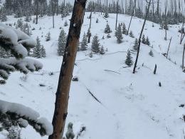
It is very dangerous in the backcountry. Heaps of snow are creating avalanches, both natural and human triggered. Today is a day to stay out of avalanche terrain, including runout zones. Avalanches can be triggered from afar (remotely) and can propagate uphill. Weak snow near the ground and/or other weak layers will break and avalanche with this new load. This is not a day to dig snowpits to try and outsmart the avalanche. Avoidance is the only tactic that works. Ian and Alex rode into Buck Ridge yesterday and confirmed the Avalanche Warning (video). There was also a skier triggered avalanche in Lick Creek that was 2-4’ deep (video) and a 2.5’ deep slide was remotely triggered in Fairy Lake (observation). Triggering avalanches is very likely today. During and immediately after storms is when avalanches are ripe to occur. As weather and visibility improves, do not err and assume the danger has passed, because it has not. Today the snowpack needs time to adjust to its new load. It can’t be rushed and the avalanche danger is rated HIGH.

Near West Yellowstone and Cooke City the mountains have dangerous avalanche conditions. In Cooke City yesterday, Beartooth Powder Guides reported 2-3 feet of new snow at higher elevations, far more than the automated weather stations are recording. Even with limited visibility, avalanches in the new snow were seen around Cooke City (observation one, two, three). The southern Madison Range, southern Gallatin Range and Lionhead area have gotten at least a foot of snow in the last 2 days. A buried weak layer (feathery surface hoar crystals) was avalanching before the storm, which means today it will be easy to trigger avalanches. While the southern mountains are not quite at Avalanche Warning criteria, they still warrant serious respect. Give all avalanche terrain a wide berth today and don’t poke the bear.
For today, the avalanche danger is rated CONSIDERABLE on all slopes since triggering avalanches is likely.
Please share avalanche, snowpack or weather observations via our website, email (mtavalanche@gmail.com), phone (406-587-6984), or Instagram (#gnfacobs).

The mountains have dangerous avalanche conditions. A buried weak layer (feathery surface hoar crystals) was avalanching before the storm, which means today it will be easy to trigger avalanches. While the southern mountains are not quite at Avalanche Warning criteria, they still warrant serious respect. Give all avalanche terrain a wide berth today and don’t poke the bear.
KING AND QUEEN OF THE RIDGE, FEBRUARY 4TH
Do you like to hike? Do you like to ski? Then the King & Queen of the Ridge is for you. Hike, ski and raise money for the Friends of the Avalanche Center in their 2nd biggest fundraiser of the year. Join the effort to promote and support avalanche safety and awareness! Fundraising prizes for the top 5 individuals who raise over $500. No racing is necessary to compete for the fundraising prizes. Info is HERE. Race participants for the February 4th event must register separately with Bridger Bowl HERE.
Upcoming Avalanche Education and Events
Our education calendar is full of awareness lectures and field courses. Check it out: Events and Education Calendar.
February 4, 9 a.m.-3 p.m., LIVINGSTON Avalanche Fundamentals. Information and course registration are HERE.
February 5, 10 a.m.-2p.m. Companion Rescue Clinic Field Day in the Bozeman area. Required Online Classroom Session at 6 p.m. on Feb 3. Information and course registration are HERE.
February 9, FREE Avalanche Awareness at REI Bozeman. More details to come.
February 11, 10 a.m.-2p.m. Companion Rescue Clinic Field Day in the Bozeman area. Required Online Classroom Session at 6 p.m. on Feb 10. Information and course registration are HERE.
Every Saturday, 10 a.m. - 2:00 p.m. Avalanche Rescue Training, drop in for any amount of time. Round Lake Warming Hut, Cooke City. Free.
Loss in the Outdoors, is a support group for those who have been affected by grief and loss related to outdoor pursuits. Check out the link for more information.
Check out the weather and avalanche log for a rundown of recent weather and avalanche conditions.