Good morning. This is Ian Hoyer with the Gallatin National Forest Avalanche Forecast on Friday, March 24th at 7:00 a.m. This information is sponsored by Blitz Motorsports and Yamaha and Avalanche Alliance. This forecast does not apply to operating ski areas.
At 6 a.m, there are a trace to 4” of new snow. Winds are 15-20 mph out of the southwest and west with gusts of 25-30 mph. Temperatures are in the teens this morning and will rise into the 20s and lows 30s F this afternoon. Moderate southwest and west winds will continue. Snowfall will pick up through the day. Expect 2-4” by sunset in most of the advisory area and potentially up to 8” near Big Sky. By tomorrow morning, accumulations will be 12-18” in the Bozeman and Big Sky areas, with 4-8” near West Yellowstone and Cooke City.

All Regions
There are two major avalanche concerns today - avalanches breaking in the new and windblown snow and deep slab avalanches.
As it snows and the new snow is drifted, expect to trigger small slides. These avalanches will get deeper and more dangerous as the snowfall piles up later this afternoon. Be wary once more than a couple inches of snow have accumulated, especially in places where a small slide could push you into rocks, trees, or gullies. Bursts of rapid snowfall will make the new snow very reactive. Slides could also break a little deeper on new snow from earlier in the week. Watch for cracks shooting out in front of your skis or sled as a sign that the new snow is unstable and ready to avalanche on steep slopes.
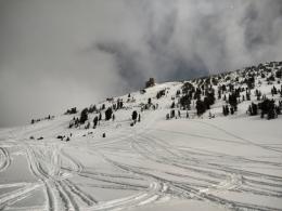
The less likely, but larger and much more dangerous concern is deep slab avalanches. Yesterday, an avalanche near Daisy Pass, outside Cooke City, broke 4 ft deep and 150 ft wide and caught two snowmobilers (details and photos, video). One rider suffered a femur fracture, requiring a helicopter flight to the hospital. We also got reports of a deep slab avalanche that broke recently (and may have been skier triggered) on Elephant Mtn. in Hyalite Canyon (details and photos). The deepest part of the crown was estimated to be 8-10 ft deep. Everytime it has snowed in the last month we’ve seen a deep slab avalanche break somewhere in our advisory area (Lionhead video, Taylor Fork video, Cooke City avalanche video). This makes us nervous of even the relatively small snowfall amounts we’re expecting today. Avoidance is the only failsafe way to deal with this problem. If you do choose to take your chances and ride slopes steeper than 30 degrees, be obsessed with the potential consequences. Choose smaller slopes rather than going for large ones, pay attention to the runout beneath those slopes and select less wind-loaded terrain.
With heavy snowfall tonight, expect a dramatic increase in the hazard by tomorrow morning.
The avalanche danger is MODERATE.
Please share avalanche, snowpack or weather observations via our website, email (mtavalanche@gmail.com), phone (406-587-6984), or Instagram (#gnfacobs).
Upcoming Avalanche Education and Events
Our education calendar is full of awareness lectures and field courses. Check it out: Events and Education Calendar.
Sunday, March 26, Avalanche Alliance Sweepstakes! Win a custom 2022 Ford 350 Super-Duty truck or many other items. Proceeds help support avalanche centers. Use code LASTCHANCE to receive 40% more tickets. Winners will be chosen at the Jackson Hole Hill Climb.
Loss in the Outdoors is a support group for those affected by grief and loss related to outdoor pursuits. Check out the link for more information.
On Wednesday, March 22nd, a snowmobiler was killed in an avalanche in central Idaho. This brings the total number of avalanche fatalities in March to 7 people across the U.S.
More info on each event is available at the Avalanche.org Accidents Page.