Good morning. This is Ian Hoyer with the Gallatin National Forest Avalanche Forecast on Friday, February 9th at 7:00 a.m. Today’s forecast is sponsored by Alpine Yamaha in Livingston and Gallatin County Sheriff Search and Rescue. This forecast does not apply to operating ski areas.
AVALANCHE WARNING
We are continuing a Backcountry Avalanche Warning for the Centennial Mountains in Island Park, the Lionhead area near West Yellowstone, and the Southern Madison and Southern Gallatin Ranges. New and wind-drifted snow are overloading an exceptionally weak snowpack, creating very dangerous avalanche conditions. Human-triggered and natural avalanches are likely. Avoid avalanche terrain and avalanche runout zones. This warning will expire or be updated by 6:00 a.m. on Saturday, February 10th.
There are 3-6” of low density new snow around Big Sky, West Yellowstone, Island Park and Cooke City with 1-2” around Bozeman. Mountain temperatures are in the teens F this morning with 5-15 mph winds from the southwest to northwest. Today, temperatures rise into the high teens and 20s F with 5-15 mph winds shifting more northerly by this afternoon. Snowfall today and tonight will add up to 2-4” by tomorrow morning.
Avalanche Warning
The avalanche warning continues for the mountains around West Yellowstone and Island Park. Another 6” of snow yesterday with continued snowfall today combined with the 2-3 ft of snow that fell over the last week make both natural and human triggered avalanches likely. We’ve been warning you about the remarkably weak snow lower in the snowpack all season and it is now being put through its biggest test yet. It’s not handling it well. On Wednesday, snowmobilers in Tepee Basin triggered an avalanche from a distance that broke 4 feet deep and a mile wide (detail and video). This is a huge avalanche, the biggest we’ve seen all season. Carefully ponder what it would mean to trigger a similar slide before even approaching the runout zone beneath a steep slope today.
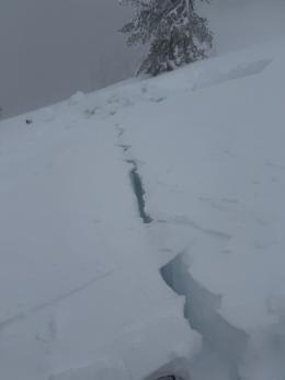
Riding in Island Park yesterday, we saw no signs of instability such as cracking or collapsing, before we came upon a recent rider triggered slide (video). As the weak layers get buried deeper, they will give less warning signs before avalanching. Don’t let this trick you. Don’t look for signs of instability to tell you to avoid steep slopes today - just make a plan to avoid riding on, or beneath, slopes steeper than 30 degrees and stick to that plan religiously. .
The avalanche danger is HIGH.

Another 1-2” of new snow around Bozeman, 4” in Cooke City and 2-6” around Big Sky are keeping avalanche conditions dangerous. With less recent snow, conditions aren’t quite as touchy as further south, but don’t take this as any sort of glowing endorsement of the stability, human triggered avalanches are still likely today. The snowpack has been incrementally loaded over the last week, keeping it teetering on the edge. Don’t be the thing that tips it over that edge. A natural avalanche and many collapses near Cooke City (details and photo, observation) on Wednesday are clear signs the snowpack remains unstable. Natural avalanches earlier this week in Beehive Basin, the Bridger Range, and east of Cooke City are good examples of the sorts of slides you could trigger today.
Cautious route finding and conservative decision making are essential for a safe day in the backcountry today. Avoiding slopes steeper than 30 degrees is the best way to avoid triggering and being caught by a dangerous slide. Also be cautious passing beneath these slopes as you can trigger a slide from below.
The avalanche danger is CONSIDERABLE.
If you get out please submit an observation. It does not need to be technical. Did you see any avalanches? How much snow is on the ground? Was the wind moving snow? Simple observations are incredibly valuable. You can also contact us by email (mtavalanche@gmail.com), phone (406-587-6984), or Instagram (#gnfacobs).
Upcoming Avalanche Education and Events
Our education calendar is full of awareness lectures and field courses. Check it out: Events and Education Calendar.
Every weekend in Cooke City: Friday at The Antlers at 7 p.m., Free Avalanche Awareness and Current Conditions talk, and Saturday from 10 a.m.-2 p.m. at Round Lake Warming Hut, Free Rescue Practice.
Loss in the Outdoors is a support group for those affected by loss and grief related to outdoor pursuits. Check out the link for more information.
King and Queen of the Ridge Rescheduled for TOMORROW, Saturday, February 10th
With a favorable forecast for the next couple of days, Bridger Bowl is rescheduling the King & Queen to be held on the Apron TOMORROW, Saturday, February 10th. There are still a few spots open. Registration will close at noon TODAY, and all pledges must be made before 1:15 pm on February 10th.
Thank you to Bridger Bowl for working through weather and snowpack challenges to host this event. Thank you all for your flexibility. The event meeting is at 8 am on Saturday in the Jim Bridger Lodge cafeteria. More information from Bridger Bowl is HERE. More fundraiser information or donate HERE.
From AP News: Avalanche forecasters try to curb deaths as skiers and snowmobilers flock to backcountry areas. The GNFAC and Cooke City are highlighted.