Good morning. This is Ian Hoyer with the Gallatin National Forest Avalanche Forecast on Friday, February 16th at 7:00 a.m. Today’s forecast is sponsored by Avalanche Alliance and Idaho State Snowmobile Association - Avalanche Fund. This forecast does not apply to operating ski areas.
In the last 24 hours, 3-7” of new snow has fallen across most of the advisory area, with 2” in the Bridger Range. Temperatures this morning range from the single digits to teens F. Winds are 10-20 mph with 20-30 mph gusts out of the west to northwest, except in the Bridger Range which have also had some east winds. Winds tapered off a bit overnight and will be 5-15 mph and generally northerly today. Snowfall will finish up this morning with at most another inch or two accumulating. Skies will clear through the day with high temperatures reaching the teens and 20s F.
Large avalanches will be easily triggered today. In the last 48 hours, 8-15” of snow (0.6-1.0” of snow water equivalent) have fallen and strong winds have been drifting the new snow into deeper slabs. The amount of avalanche activity over the last two weeks has been remarkable with slides breaking naturally, being triggered from far away and breaking unusually wide (wx and avalanche log). New snow and windloading are pushing the exceptionally weak layers in the lower snowpack to their breaking point again.
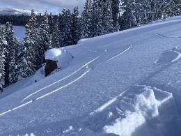
Yesterday, riders near Big Sky triggered a slide from a distance that broke 3-4 deep and 1500 ft wide (observation). Before even thinking about crossing beneath a steep slope today, consider what it would mean for all that snow to release above you. Expect similarly touchy and dangerous conditions today.
Now is not the time to try to use stability tests to outsmart the snowpack or to watch for signs of instability and factor those into your travel plans (Beehive video). The big picture of recent avalanches, with snowfall and drifting snow loading a very weak snowpack tells us to simply avoid steep slopes today.
On wind-loaded slopes, the avalanche danger is HIGH. On all other slopes, the avalanche danger is CONSIDERABLE, which still means you are likely going to trigger an avalanche if you get on or even near any slope steeper than 30 degrees.

Around Bozeman, a bit less snow has fallen (6-7” with 0.4” SWE over the last two days) so conditions are a bit less touchy, but still quite dangerous. Similar snowfall totals last weekend caused several natural avalanches on Bridger and Saddle Peaks (details).
Large, human triggered avalanches are likely today, breaking on the weak layers low in the snowpack. Shifting winds from unusual directions (east) may have windloaded slopes that aren’t usually windloaded. Avoiding all slopes steeper than 30 degrees and being wary of crossing beneath them is the wise choice today.
The avalanche danger is CONSIDERABLE.
If you get out please submit an observation. It does not need to be technical. Did you see any avalanches? How much snow is on the ground? Was the wind moving snow? Simple observations are incredibly valuable. You can also contact us by email (mtavalanche@gmail.com), phone (406-587-6984), or Instagram (#gnfacobs).
Upcoming Avalanche Education and Events
Our education calendar is full of awareness lectures and field courses. Check it out: Events and Education Calendar.
Every weekend in Cooke City: Friday at The Antlers at 7 p.m., Free Avalanche Awareness and Current Conditions talk, and Saturday from 10 a.m.-2 p.m. at Round Lake Warming Hut, Free Rescue Practice.
Loss in the Outdoors is a support group for those affected by loss and grief related to outdoor pursuits. Check out the link for more information.
A skier and a snowmobiler lost their lives in avalanche accidents in Colorado and Wyoming this week. Read accident reports to learn from these tragedies.
In Alex’s recent article for the Montana Snowmobile Association, he revisits our concerns about the abnormally weak snowpack in Southwest Montana. In the last week, there were nearly 50 entries in our Avalanche Activity Log. Do not mess with this snowpack!