Advisory Archive
The northern mountains received a trace to one inch of new snow yesterday morning. In the southern ranges 2-4 inches fell with Cooke City picking up eight. Winds gusted into the 50s yesterday, but have dropped to 20-30 mph out of the west to southwest which is where they will remain today. At 5 a.m. mountain temperatures are in the high teens to low 20s, but will rise to the mid-20s under cloudy skies. More snow will fall today and tonight. By morning I anticipate 2-4 inches in the northern mountains and closer to six inches near West Yellowstone and Cooke City.

Snow fell yesterday and again last night. Since the beginning of the storm at 4 a.m. yesterday, seven to nine inches fell in the northern mountains (around Bozeman and Big Sky) with two to four inches in the southern ranges. Wind speeds have picked up out of the northwest and are blowing 20-30 mph. These speeds will increase slightly this morning and switch to the southwest later today. Under cloudy skies intermittent snowfall will measure one to two inches as temperatures climb from the teens to low 20s.
Overnight 2-4 inches of snow fell in most mountain locations. At 4 am temperatures are in the single digits to low teens and winds are blowing 15-30 mph out of the WNW with gusts reaching close to 40 mph. Today, temperatures will warm into the 20s F and winds will continue to blow 15-30 from the WNW. A northwest flow will remain over the area today and tonight. Light bands of snow will continue to move through southwest Montana providing an additional 1-3 inches of snow by tomorrow morning.
Over the past 24 hours a moist northwest flow delivered 18” of cold smoke powder to the Bridger Range. The northern Gallatin and northern Madison Ranges along with the mountains around Cooke City picked up 8-10 inches. The mountains around West Yellowstone received 2-3 inches. Currently, temperatures are in the single digits above or below zero F and winds are blowing 5-10 mph from the WNW. Today, high temperatures will be 5-10 degrees above zero F and winds will gradually increase out of the WNW. Skies will be mostly clear this morning, but will become mostly cloudy by this afternoon. Tomorrow looks to be a warmer with snow likely.

Since yesterday, the mountains near Cooke City received 10 inches of snow, near Big Sky 4-6 inches of snow, and 2-3 inches most other places. This morning winds were averaging 20-30 mph from the W and NW with gusts of 40-60 mph. Temperatures were in the single digits to low teens F. Today, another 1-2 inches should fall and temperatures should bottom out at 0 degrees F before warming back up a few degrees. Fortunately winds should ease by afternoon and blow 10-20 mph from the NW. Tonight through Sunday should be dry with more snow coming Sunday night.
Overnight the northern Madison and northern Gallatin Ranges and the mountains around Cooke City received 7-10 inches low density snow (5% density). The Bridger Range received 5 inches. The mountains near West Yellowstone including the southern Madison and southern Gallatin Ranges received 1-2 inches. This morning temperatures were mostly in the low to mid-teens F and westerly winds were averaging 15-20 mph with gusts of 30 mph. In Hyalite Canyon winds were averaging 28 mph and gusting to 50 mph.
A few more inches of snow should fall this morning. Today temperatures will struggle to reach the low 20s F and westerly winds will continue blowing 15-30 mph. Snowfall will return this evening with similar amounts as last night if not more. This weather pattern has a slight NW flow and more energy associated with it than last night. I don’t think this pattern will favor the Bridger Range more than other areas….but there’s a chance. By tomorrow morning most places should get 8-12 inches of new snow.

Yesterday rain fell in the valleys and snow fell in the mountains. Near Bozeman and Big Sky 1-3 inches of dense snow fell. Near West Yellowstone and Cooke City 3-5 inches of dense snow fell. Overnight temperatures dropped to the high teens and low 20s F. Winds eased a little since yesterday and were blowing 15-25 mph from the WSW this morning. Both winds and temperatures shouldn’t change much today, and snowfall will return sometime this afternoon or early evening. By tomorrow morning most areas will receive 3-5 inches of snow with more coming Friday night followed by much colder temperatures for Saturday.
Unseasonably warm temperatures reached the mid-thirties at 8,000 feet. The new snow was on the cusp of being rain. The southern mountains picked up .7 to 1 inch of Snow Water Equivalency (SWE) which measured 3-6 inches of new snow. Around Bozeman .2-.3 inches of SWE fell measuring only a trace of snow while the Big Sky area got two inches. Winds are averaging 15-25 mph out of the west to southwest with gusts of 40 mph. Later this afternoon, temperatures will drop into the low 20s with gusty winds and 2-3 inches of snow falling in the southern mountains.


Under partly cloudy skies there’s no new snow to report. Mountain temperatures are in the teens to 20 degrees this morning with southwest winds averaging 10-20 mph and gusts to 30. A moist pacific system will increase cloud cover today. Winds will remain moderate as temperatures rise into the upper 20s. In the southern mountains 1-2 inches of new snow will fall by morning. The weather models show unsettled weather, so my hopes are high for more snow this week.
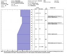
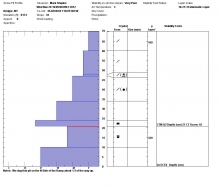
Since yesterday morning Carrot Basin Snotel site in the southern Madison Range picked up 1.4 inches of SWE (snow water equivalent) while Madison Plateau and Fisher Creek are showing close to one inch of SWE. That translates to nearly a foot of new snow. The mountains around Bozeman and Big Sky picked up 2-4 inches of snow.
At 4 am temperatures are in the teens to low 20s and winds are blowing 10-20 out of the WNW. Today, a westerly flow will keep skies partly to mostly cloudy and winds will continue to blow 10-20 out of the west. Temperatures will warm into the mid-20s to low 30s. No precipitation is expected today.