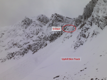
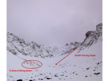
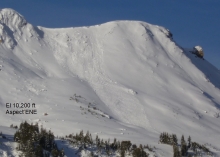
Advisory Archive
Over the past 24 hours the southern mountains picked up 4-6 inches of snow at elevations above 8,000 ft. The mountains around Bozeman and Big Sky picked up 1-2 inches. Currently, temperatures are in the high 20s to mid-30s and winds are blowing 20-30 mph out of WSW with gusts reaching close to 50 in many locations.
Today, the weather pattern will remain active as another storm moves into the region. Temperatures will remain warm with highs reaching into the upper 30s. Snow will develop late this morning and winds will stay strong out of the WSW. The southern mountains will receive the heaviest amount of snow with 8-10 inches possible by tomorrow morning. Big Sky will likely see 4-6 inches by tomorrow and the Bridgers will see 2-4 inches. Temperatures will drop this evening as a cold front moves over the area.


Since yesterday morning the southern mountains got 8-12 inches of dense new snow. The Bridger Range picked up four inches, Big Sky received one to two inches and the northern Gallatin Range got a dusting. Ridgetop winds are west to southwest at 20-30 mph, but gusting to 40 mph outside Cooke City. Mountain temperatures are in the mid to high 20s. More snow is on track for later this afternoon with another storm due Sunday. By morning the mountains will see 2-4 inches of new snow in the north and 4-6 inches in the south.


Since yesterday morning 1-2 inches of snow fell in the mountains around Cooke City and West Yellowstone; the rest of our advisory area remained dry. At 5 am temperatures are ranging from the high 20s to mid-30s and winds are blowing 20-30 mph out of the WSW with gusts reaching close to 50 mph. Today, highs will warm into the upper 30s to low 40s and winds will stay strong out of the SW. The first of a series of storms will move into southwest Montana by early afternoon. Snow will develop over the southern mountains where 4-6 inches is possible by tomorrow morning. The mountains around Bozeman and Big Sky will see 1-2 inches by tomorrow.

A moist weather system streaming off the Pacific is producing snow, mainly in our southern mountains. At 6 a.m. the mountains around Cooke City, West Yellowstone and the southern Madison Ranges have gotten 4-5 inches. Two to three inches has fallen around Big Sky, one inch in the northern Gallatins and a dusting in the Bridger Range. Winds are light at 10-15 mph out of the W to SW with temperatures in the low 20s. Another 1-2 inches will fall today, but skies will clear tonight with no further storms predicted through Wednesday.

Today is a day of thanks, and right this moment I’m thankful that it finally got cold and snowed. I know that’s pretty shallow, especially compared with family, health and life, but it’s a thanks nonetheless. The Bridger Range fared the best with seven inches of new snow. The northern Gallatin and Madison Ranges and mountains around Cooke City received 4-6 inches while the West Yellowstone area got 2-3 inches. Temperatures dropped into the low teens this morning with westerly winds blowing 20 mph with gusts to 40. Clear skies are expected through Friday as mountain temperatures reach into the high 30s and winds remain out of the west at 20-30 mph. Another system on Saturday night and Sunday should bring additional snow.
Yesterday was a beautiful sunny day with calm winds. Overnight, southerly winds increased to 20-40 mph and calmed a little this morning. A small disturbance may bring a dusting of snow tonight; otherwise, the next few days will have warm dry weather and relatively calm winds. Winds should increase Sunday ahead of an approaching cold front that will bring colder temperatures and more snow starting late Sunday.
The storm is tapering off this morning and will drop only an inch or two more. At 5 a.m. the snowfall amounts are approximately 16 inches in the Bridger Range, 8-12 inches in the mountains around Big Sky and Bozeman, and 6-8 inches outside West Yellowstone and Cooke City. Winds have been blowing 5-15 mph out of the southeast to southwest with temperatures dropping in the last 36 hours to the single digits. Tonight, temperatures will read near zero under clearing skies. The rest of the week looks chilly with the possibility of flurries Wednesday followed by high pressure.

Yesterday precipitation fell mostly in the mountains near Bozeman and Big Sky with an inch or two of snow above 8000 ft. Temperatures cooled overnight and were in the low 20s F this morning. Temperatures shouldn’t warm much today under partly cloudy skies. Saturday morning should be sunny with a short-lived ridge of high pressure. More rain and snow will come Saturday evening and Sunday mostly in the areas near Bozeman.
A weak ridge of high pressure is building over the region producing clear skies and calm conditions. Currently, mountain temperatures are ranging from the single digits to mid-teens and winds are blowing out of the WNW at 5-15 mph. Today, the ridge will begin to break down as another storm system approaches from the west. Temperatures will warm into the 20s today and winds will gradually increase blowing 15-25 out of the WNW. Snow showers should arrive around midnight and will remain over the area through tomorrow. Accumulations of 1-3 inches are possible by tomorrow afternoon. The storm will push east by Saturday night and Sunday looks to be a nicer day.
We just got our first taste of winter and I’m salivating for the full meal. Temperatures dropped into the 20s and snow fell throughout southwest Montana. The mountains around Cooke City picked up 12” of wet, dense snow (2” of SWE) while other areas got 2-4 inches. Lingering precipitation today with unsettled weather all week should keep winter sports on the brain.
Mark and Eric put up the Hyalite weather station on Flanders peak last Friday (video). Our Weather page has links to many of the stations; however, they are not all operational yet.
Keep the budding flames of winter alive by attending this Friday’s PowderBlast sponsored by MIG, Grizzly Outfitters and Mystery Ranch. It’s the Friend’s annual fundraiser held at 6:30 p.m. at the Emerson Cultural Center. $30 gets you food, beverages, music and awesome outdoor gear at our silent auction and raffle! Buy your tickers HERE (or at the Door) or check out our Facebook page for more information.