Good morning. This is Dave Zinn with the Gallatin National Forest Avalanche Forecast on Thursday, February 8th at 7:00 a.m. Today’s forecast is sponsored by Basecamp Gallatin and Yamaha and Montana State Parks. This forecast does not apply to operating ski areas.
AVALANCHE WARNING
The Gallatin National Forest Avalanche Center is continuing a Backcountry Avalanche Warning for the Centennial Mountains in Island Park, the Lionhead area near West Yellowstone, and the southern Madison and southern Gallatin ranges. New and wind-drifted snow are overloading an exceptionally weak snowpack, creating very dangerous avalanche conditions. Human-triggered and natural avalanches are likely. Avoid avalanche terrain and avalanche runout zones. The avalanche danger is HIGH on all slopes. Contact the Gallatin National Forest Avalanche Center for more detailed information.
This warning will expire or be updated by 6:00 a.m. on Friday, February 9th.
Mountain temperatures are in the teens F this morning with 5-15 mph winds from the southwest to northwest. The mountains received 1-3” of new snow. Today, temperatures will be in the 20s F with 5-15 mph winds from the west to southwest, and the mountains will pick up an additional 1-3” of snow by tomorrow morning.
Avalanche Warning
Very dangerous avalanche conditions exist in the Southern Madison, Southern Gallatin, and Centennial Ranges, as well as the Lionhead area near West Yellowstone. An avalanche warning is in place, and human-triggered avalanches are very likely.
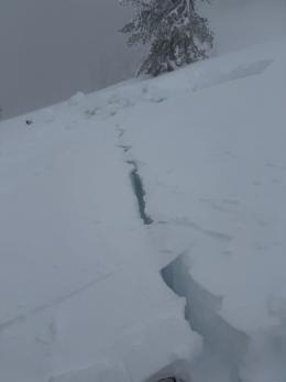
Since Saturday, three feet of snow fell in the Centennial Mountains of Island Park, equal to 3.3” of snow water equivalent (SWE). In the same period, nearly two feet of snow, equal to 1.8-2.2” of SWE, fell south of Big Sky through the Lionhead area. Our extraordinarily weak snowpack is failing to bear the weight of this new snow and is avalanching. Yesterday, snowmobilers in Tepee Basin triggered an avalanche from a distance away that broke 4 feet deep and one mile wide. Groups in the area confirmed that all parties were accounted for (detail and video). At Bacon Rind on Monday, Doug and I watched trees shake and drop snow off their branches as we triggered collapse after collapse, carefully sticking to terrain not steep enough to slide (video and observation).
As I said in my video from the Taylor Fork yesterday, enjoy the fresh snow from the relative safety of slopes less than 30 degrees without steeper terrain above or nearby. Do not go onto slopes steep enough to avalanche or into runout zones.
The avalanche danger is HIGH.

Dangerous avalanche conditions exist in the mountains around Bozeman, Big Sky, and Cooke City. Incremental loading continued with 1-2” of snow yesterday and storm totals of 11-15” since Friday, equal to 1.0-1.3” of snow water equivalent. New and wind-drifted snow is adding stress to persistent weak layers buried 1-3 feet deep.
Avalanche activity and recent red flags of instability indicate that human-triggered avalanches are likely on slopes steep enough to slide. Yesterday, there was a natural avalanche on the east side of Henderson Mountain, and a group of skiers on the south side of Henderson triggered “at least 20 collapses” or whumphs (details and photo, observation). A group in the Northern Gallatin Range skied across a slope that collapsed and cracked but remained in place (observation). Avalanches earlier this week in Beehive Basin, Bridger Range, and east of Cooke City are all indicative of our weak snowpack’s capacity for avalanching. Alex explained Cooke City’s dangerous snowpack in his videos earlier this week (video 1, video 2), and Doug discussed how the size of potential avalanches increased with new snow from Beehive Basin (video and observation).
Conservative decision-making and cautious route-finding that largely avoids travel in avalanche terrain and runout zones are essential to returning home safely.
The avalanche danger is CONSIDERABLE.
If you venture out, please fill an observation form. It does not need to be technical. Did you see any avalanches? How much snow is on the ground? Was the wind moving snow? Simple observations are incredibly valuable. You can also contact us via email (mtavalanche@gmail.com), phone (406-587-6984), or Instagram (#gnfacobs).
Upcoming Avalanche Education and Events
Our education calendar is full of awareness lectures and field courses. Check it out: Events and Education Calendar.
Every weekend in Cooke City: Friday at The Antlers at 7 p.m., Free Avalanche Awareness and Current Conditions talk, and Saturday from 10 a.m.-2 p.m. at Round Lake Warming Hut, Free Rescue Practice.
Loss in the Outdoors is a support group for those affected by loss and grief related to outdoor pursuits. Check out the link for more information.
King and Queen of the Ridge Rescheduled for Saturday, February 10th
With a favorable forecast for the next couple of days, Bridger Bowl is rescheduling the King & Queen to be held on the Apron this Saturday, February 10th. There are still a few spots open. Registration will close at noon on February 9, and all pledges must be made before 1:15 pm on February 10th.
Thank you to Bridger Bowl for working through weather and snowpack challenges to host this event. Thank you all for your flexibility. The event meeting is at 8 am on Saturday in the Jim Bridger Lodge cafeteria. More information from Bridger Bowl is HERE. More fundraiser information or donate HERE.
From AP News: Avalanche forecasters try to curb deaths as skiers and snowmobilers flock to backcountry areas. The GNFAC and Cooke City are highlighted.