Good morning. This is Doug Chabot with the Gallatin National Forest Avalanche Forecast on Wednesday, February 7th at 7:00 a.m. Today’s forecast is sponsored by Cooke City Super 8/Bearclaw Bob’s and Idaho State Snowmobile Association - Avalanche Fund. This forecast does not apply to operating ski areas.
AVALANCHE WARNING
We are continuing a Backcountry Avalanche Warning for the Centennial Mountains in Island Park, the Lionhead area near West Yellowstone, and the southern Madison and southern Gallatin Ranges. New snow and wind are forming drifts and overloading an exceptionally weak snowpack, creating very dangerous avalanche conditions. Human-triggered and natural avalanches are likely. Avoid avalanche terrain and avalanche runout zones. This warning will expire or be updated by 6:00 a.m. on Thursday, February 8th.
In the last 24 hours, Island Park picked up 12” of new snow, West Yellowstone to Big Sky got 6”, Bracket Creek SNOTEL in the Bridger Range received 4”, Cooke City 3”, and Hyalite 2”. Wind is E-SE at 10-15 mph with gusts of 30 mph, except Sawtelle Peak which has gusts of 54 mph. Temperatures are in the low 20s and snow will fall today and tonight. Wind will shift NW-SW at 15-20 mph. By tomorrow morning 6” will accumulate around West Yellowstone and Island Park with 2-3” everywhere else.
Avalanche Warning
We are continuing an Avalanche Warning in the southern Gallatin and southern Madison Ranges, the Lionhead area and Island Park. Very dangerous avalanche conditions exist.
Island Park received a foot of new snow with 50+ mph wind gusts. The southern mountains, including West Yellowstone picked up another 6”. It has been snowing since Friday with Island Park receiving a total of 28” (3” snow water equivalent) and 18” in Lionhead and the southern mountains (1.6-2” SWE). The snowpack is weak and unstable and the weight of the new snow will cause widespread avalanches. It is still snowing and blowing. On Monday, Dave and I threaded our way up Bacon Rind and triggered collapses and wide cracks every time we stepped off the skin track (video and observation). More snow since then is keeping the backcountry dangerous and triggering a deadly avalanche is very likely. Today is a day to avoid being on or underneath avalanche terrain. The avalanche danger is HIGH.

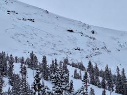
Since Friday, the mountains around Bozeman, Big Sky, and Cooke City have been incrementally loading every day with a total snowfall of 8-12” (0.8-1.2” of SWE). Avalanche activity early in the week in Beehive Basin and in the Bridger Range point to a snowpack with poor stability. In Cooke City, Alex has been skiing and riding and found a dangerous snowpack both north (video) and south (video) of town. A sledder confirmed the poor stability when he triggered a slide in “The Plug” on Highway 212 east of town (observation and photo).
Ian and I skied into Beehive Basin yesterday. The snowfall since Friday has doubled the slab depth above our problematic December weak layers (video and observation). Traveling in avalanche terrain is dangerous. As it keeps snowing it will get easier to trigger slides 1-2 feet deep. Passing beneath steep slopes is not advised as collapses warn us that we can trigger slides from flat ground. The avalanche danger is CONSIDERABLE.
If you venture out, please fill an observation form. It does not need to be technical. Did you see any avalanches? How much snow is on the ground? Was the wind moving snow? Simple observations are incredibly valuable. You can also contact us via email (mtavalanche@gmail.com), phone (406-587-6984), or Instagram (#gnfacobs).
Upcoming Avalanche Education and Events
Our education calendar is full of awareness lectures and field courses. Check it out: Events and Education Calendar.
Every weekend in Cooke City: Friday at The Antlers at 7 p.m., Free Avalanche Awareness and Current Conditions talk, and Saturday from 10 a.m.-2 p.m. at Round Lake Warming Hut, Free Rescue Practice.
POSTPONED: King and Queen of the Ridge. Bridger Bowl’s community event series events this weekend are postponed, including King & Queen - stay tuned, details coming soon.
Loss in the Outdoors is a support group for those affected by loss and grief related to outdoor pursuits. Check out the link for more information.
From AP News: Avalanche forecasters try to curb deaths as skiers and snowmobilers flock to backcountry areas. The GNFAC and Cooke City are highlighted.