Good Morning. This is Alex Marienthal with the Gallatin National Forest Avalanche Advisory issued on Sunday, January 7th at 6:45 a.m. Today’s advisory is sponsored by Bridger Bowl and Beartooth Powder Guides. This advisory does not apply to operating ski areas.
Cabin Creek Avalanche Accident Report
On Tuesday, January 2nd, a snowmobiler was caught and killed in an avalanche in Cabin Creek to the west of Sage Peak in the southern Madison Range. Alex and Doug investigated the slide on Wednesday. You can view a detailed report of the accident HERE.
The mountains got 1-3” of snow yesterday. Wind overnight was westerly at 15-25 mph with gusts of 30-40 mph. Temperatures this morning are teens to low 20s F and will reach highs 20s to low 30s F today. Wind will be west-southwest at 15-25 mph. Tonight the mountains near Big Sky and Cooke City could get 2-3” of snow with a trace to 1” elsewhere.

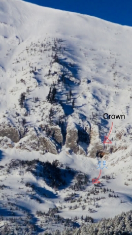
Large avalanches breaking 2-4’ deep on weak facets remain possible, though difficult to trigger. The snowpack has had time to adjust to the rapid, heavy load that fell over a week ago. Many slopes are stable, but some are not and large avalanches are possible to trigger, similar to the fatal slide in Cabin Creek (photo, video) and close call on Crown Butte (video, photo).
Today, diligent snowpack assessment is essential if you plan to ride in avalanche terrain. Start with a review of our photos and videos pages to learn general character and distribution of unstable slopes. Additionally, before skiing or riding steep slopes dig a pit or two on terrain similar to what you plan to ride for the day (video). Avoid steep slopes if stability tests break clean, or if you find sugary, weak facets buried 2-4’ deep (video).
An equally important problem to avoid are fresh wind slabs 6-12" thick formed by westerly winds. These slabs are located near ridgelines and easy to trigger. Wind slabs today are most harmful if they catch you above cliffs, trees, or confined gullies where snow can pile deep. Carefully assess the terrain for consequences of even small slides, and avoid freshly wind loaded slopes. Wet loose avalanches are also possible at low elevations later in the day with above freezing temperatures (photo). Avoid steep terrain if the snow is moist or you see fresh pinwheels (photo).
Today, fresh wind slabs are easy to trigger and larger avalanches possible. The avalanche danger is MODERATE on all slopes.
Check out pictures that have been added to our Photos page since Monday morning documenting many avalanches.
If you get out and have any avalanche or snowpack observations to share, drop a line via our website, email (mtavalanche@gmail.com), phone (406-587-6984), or Instagram (#gnfacobs).
Upcoming Avalanche Education and Events
BOZEMAN
Jan. 9, Women’s Avalanche Awareness and Beacon Clinic, 6-8 p.m. at Beall Park
Jan. 12 and 13, Companion Rescue Clinic, Info and Register
Jan. 17, 18 and 20 or 21, Introduction to Avalanches w/ Field Day, Info and Register Here
Jan. 24, 25 and 27, Advanced Avalanche Workshop w. Field Day, Info and Register Here
Feb. 9 and 10, Companion Rescue Clinic, Info and Register
WEST YELLOWSTONE
Jan. 20, Avalanche Awareness, 7-8 p.m. at West Yellowstone Holiday Inn Conference Center
BIG TIMBER
Jan. 11, Avalanche Awareness, 6-7 p.m. at Sweet Grass County High School
BUTTE
Jan. 13, Rescue Clinic, 10 a.m. at Homestake Lodge
Dillon
Jan. 16, Avalanche Awareness, 6:30-8 p.m. at U.M. Western Library
COOKE CITY
Every Friday and Saturday, Current Conditions Update and Avalanche Rescue, Friday 6:30-7:30 p.m. at The Antler's Lodge in January. Saturday anytime between 10-2 @ Round Lake.
Check out Dashboard Talks: Episode 2, a 2.5-minute video of Dave Zinn and Doug Chabot discussing how often you should practice with your rescue gear.