Good Morning. This is Eric Knoff with the Gallatin National Forest Avalanche Forecast issued on Friday, December 14th at 7:00 a.m. Today’s forecast is sponsored by World Boards and Cooke City Super 8/Bearclaw. This forecast does not apply to operating ski areas.
Over the past 24 hours the mountains near West Yellowstone and Cooke City picked up 1-2” of new snow. This morning temps range from the 20’s F in the north to single digits F in the south. Winds are blowing 15-30 mph out of the west-southwest. Today, skies will be partly cloudy and temps will warm into the upper 20’s F in the north and teens in the south. Winds remain moderate to strong out of the west-southwest. There is an increasing chance for snow this evening around West Yellowstone and Cooke City. These areas will likely see 1-2” by tomorrow morning.

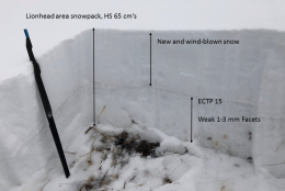
Weak facets make up the foundation of the snowpack in the Lionhead near West Yellowstone (video). This weak layer exists on all aspects and elevations. Without a wind load, the overlaying slab isn’t quite cohesive enough to propagate a fracture. On slopes that have wind drifted snow, the necessary ingredients exist to produce avalanches (photo).
Slopes leeward to west-southwest winds are the most likely to harbor thick slabs of wind drifted snow. Watch for signs of instability such as cracking/collapsing and avoid all steep slopes that appear to be wind loaded. If a slide does occur, it will fail at the ground and take season’s snowpack with it. This is not a scenario that ensures a positive outcome.
Today, wind loaded slopes hold the necessary ingredients to produce avalanches which have a MODERATE avalanche danger. Non-wind loaded slopes have a LOW avalanche danger.
The message is simple in the mountains around Bozeman, Big Sky and Cooke City: Avoid wind loaded slopes and avoid avalanches. Strong winds the past few days have hammered slopes on all aspects and elevations (video, video, photo, photo). Yesterday, my partner and I toured around the Throne in the northern Bridgers and found nearly every slope to be touched by the wind. Some slopes were scoured and firm while others had thick pillows of wind drifted snow. These thick drifts were stubborn and hard to move. The Big Sky and Bridger Bowl Ski Patrols also found fresh winds slabs reluctant to move during control work. Although wind loaded slopes are becoming harder to trigger, they still hold the potential to fail under the weight of a skier or rider. Fortunately, wind slabs are unlikely to propagate long distances and should stay relatively small in size. The lower portion of the snowpack remains strong and stable.
A secondary problem is a layer of small grained facets buried roughly a foot deep. This layer formed during the dry spell after Thanksgiving. We found this layer on the Throne and got it to propagate in one out of three stability tests (video). Without a recent load this layer won’t be much of a problem, but will be something to track with the arrival of more snow, whenever that might be.
Today, human triggered avalanches are possible on wind loaded slopes which have a MODERATE avalanche danger. Non-wind loaded slopes have a LOW avalanche danger.
If you get out and have any avalanche or snowpack observations to share, contact us via our website, email (mtavalanche@gmail.com), phone (406-587-6984), or Instagram (#gnfacobs).
Upcoming Avalanche Education and Events
Our education calendar is full of awareness lectures and field courses. Check it out: Events and Education Calendar.
COOKE CITY
Every Friday and Saturday, Rescue Training and Snowpack Update. Friday 6:30-7:30 p.m. at the Soda Butte Lodge. Saturday anytime between 10-2 @ Round Lake.
Check out our new “Avalanches and Snowpits” menu item where we list all the reported avalanche activity.