Good morning. This is Alex Marienthal with the Gallatin National Forest Avalanche Forecast issued on Saturday, January 5th at 7:00 a.m. Today’s forecast is sponsored by Highline Partners and Cooke City Super 8/Bearclaw Bob’s. This forecast does not apply to operating ski areas.
This morning there is no new snow, temperatures are high teens to mid-20s F and wind has been southwest-west at 10-20 mph with gusts to 35 mph. Today, temperatures will be in the high 20s to low 30s F with wind out of the south-southwest at 5-15 mph. This evening southwest wind will increase to 30-40 mph. Snow showers are expected early tomorrow morning and will favor the mountains near West Yellowstone. The southern ranges and West Yellowstone will get 2-4” by morning and the mountains near Bozeman, Big Sky and Cooke City will get a trace to 1” with more snow through tomorrow.

The mountains near West Yellowstone and the southern Madison and southern Gallatin ranges have an unstable snowpack with 1.5’ of weak, sugary facets on the ground. Snowfall and wind last week loaded this weak snowpack, and avalanches occurred naturally. Doug saw evidence of these avalanches last Tuesday on Lionhead Ridge near West Yellowstone (video, photo). On Thursday, Eric experienced large collapses and unstable test results at Bacon Rind (video). Yesterday I rode into Cabin Creek from the Taylor Fork and found similar unstable conditions. Our sleds easily broke through 2.5’ of snow to the ground, a sign of poor snowpack structure (video, photo).
No snow since Monday has allowed the snowpack to gain strength and avalanches are relatively harder to trigger than earlier in the week. However, recent collapsing and unstable test results, large avalanches last Monday, and an unsupportive snowpack are signs to avoid avalanche terrain. Large avalanches are possible to trigger today and avalanche danger is MODERATE.
In the mountains near Bozeman and Big Sky thick drifts of snow that formed from strong wind earlier in the week are possible to trigger. The last two days, skiers in Hyalite and the Bridgers observed crowns of natural avalanches that broke earlier this week on wind loaded slopes (photo, photo). An equally possible place to trigger an avalanche is on slopes with a relatively shallow snowpack where weak, sugary snow underlies a cohesive slab. Eric found this unstable snowpack structure on Mt. Ellis (video, photo), and the last two days skiers in Hyalite and Beehive reported collapsing (photo). Carefully assess for recent wind loading and a poor snowpack structure. If either exists, consider different or low angle terrain. Today, avalanches are possible to trigger and avalanche danger is MODERATE.

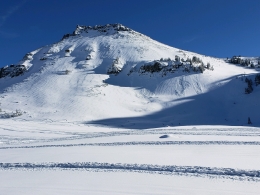
The mountains near Cooke City have had less recent snow and wind than the rest of the area, and have a relatively stronger snowpack. Doug was in Cooke City last week and found a couple weak layers of concern (video, video), but minimal loading from snow and wind makes avalanches unlikely on these weak layers. Wind earlier this week formed drifts of snow that can be triggered near ridgelines, below rock outcroppings, and on cross loaded terrain features (photo). These wind slabs have gained strength and will be difficult to trigger today, but not impossible. Minimal recent loading and no widespread buried weak layers make avalanches unlikely today and avalanche danger is LOW.
If you get out and have any avalanche or snowpack observations to share, contact us via our website, email (mtavalanche@gmail.com), phone (406-587-6984), or Instagram (#gnfacobs).
Upcoming Avalanche Education and Events
Our education calendar is full of awareness lectures and field courses. Check it out: Events and Education Calendar.
BOZEMAN
January 8, Women’s Specific Avalanche Awareness, 6:30-8 p.m. Story Mill Park, Bozeman.
January 9, 1-hr Avalanche Awareness, 7-8 p.m. Spire Climbing Center, Bozeman.
January 16, 17 and 19 or 20, Intro to Avalanches w/ Field Day, Info and Register Here.
January 23, 24 and 26, Advanced Avalanche Workshop w/ Field Day, Info and Register Here.
February 2, King and Queen of the Ridge at Bridger Bowl (fundraiser). Register with Bridger to hike in the event, and create a pledge page to raise funds with your Ridge laps.
WEST YELLOWSTONE
January 12 and 26, 1-hr Avalanche Awareness for Snowmobilers, 7-8 p.m. Holiday Inn West Yellowstone.
DILLON
January 22, 1-hr Avalanche Awareness, 6:30-7:30 p.m. U.M. Western Library.
BILLINGS
January 22, 1-hr Avalanche Awareness, 6-7 p.m. The Base Camp, Billings
COOKE CITY
Every Friday and Saturday, Rescue Training and Snowpack Update. Friday 6:30-7:30 p.m. at the Soda Butte Lodge. Saturday anytime between 10-2 @ Round Lake.
Read Doug’s recent article on Snowmobiler Education Efforts that will be published in the next issue of The Avalanche Review.