Good morning. This is Alex Marienthal with the Gallatin National Forest Avalanche Forecast issued on Sunday, January 20th at 7:00 a.m. Today’s forecast is dedicated to Tyler Stetson. Tyler was killed in an avalanche in Beehive Basin on this day eleven years ago. This forecast does not apply to operating ski areas.
Since yesterday morning the Bridger Range received 9” of heavy snow. The mountains south of Bozeman and near Big Sky got 2-4” with 5” near West Yellowstone and Cooke City. Temperatures are in the low 20s F this morning and wind has been southwest at 15-25 mph with gusts to 35 mph. Temperatures will warm to the high 20s and low 30s F today. This afternoon wind will increase to 30-45 mph out of the west to southwest. Today expect steady snowfall in the southern mountains with more throughout the advisory area tonight. By morning, near West Yellowstone and Cooke City could get up to a foot of new snow with 4-6” near Bozeman and Big Sky.
Last night the Bridger Range received 7-9” of snow equal to .7-1.3” of snow water equivalent (SWE). This heavy new snow fell on buried weak layers and firm crusts, and it will be drifted into thick slabs that are easy to trigger or can break naturally. On Friday a solo skier got partially buried in an avalanche near Fairy Lake (details, photo), and natural slides were observed on saddle peak (details). Eric went to Fairy Lake yesterday and found unstable 8-12” thick wind slabs over weak facets.
The new snow will create dangerous avalanche conditions, and the best skiing since 2018. A scary combination. Signs of instability like cracking, collapsing and natural avalanches will be clues that the snowpack is unstable. In the absence of these clues, I would still resist the temptation to ride steeper slopes and let the snowpack adjust. Avoid travel on and underneath avalanche terrain today. Avalanche danger is HIGH on wind loaded slopes and CONSIDERABLE on all other steep slopes.

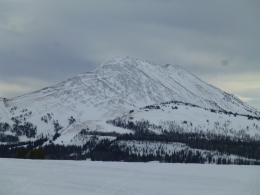
The mountains near West Yellowstone and south of Big Sky have the weakest snowpack in the advisory area. The base of the snowpack is 1.5’ of weak, sugary facets (video). Avalanches can break 2-3’ deep on this weak layer, and can propagate far and wide. It is possible to trigger these slides from lower angle terrain below steep slopes, and they are more likely on wind loaded slopes (example: photo, details). Avoid travel on and underneath steep slopes today. Human triggered avalanches are likely and avalanche danger is CONSIDERABLE. Danger could rise to HIGH on wind loaded slopes with steady snow and wind today.
I visited Cooke City the last couple days to assess how the snowpack took the weight of 10-12” of new snow (video). The snowpack was generally strong where it is deeper than three feet, and the new snow was not yet unstable on shallower weak areas (less than 3’). This is good news, but more snow today and tonight will continue to test the strength of the snowpack. Avalanches are likely to be triggered where the new snow is drifted into thick slabs, and with more snow today avalanches may become easy to trigger on all steep slopes. Avalanche danger is CONSIDERABLE on wind loaded slopes and MODERATE on all other slopes. Danger may rise to CONSIDERABLE on all slopes with steady snowfall today.

The mountains south of Bozeman and near Big Sky received the least snow with 6-7” of snow since Thursday. Avalanches are possible to trigger where wind has drifted this snow into fresh slabs. Avalanches can break larger on weak layers buried 1.5-2’ deep (video, video). On non-wind loaded slopes, loose snow and slab avalanches of new snow are possible. Carefully assess the snowpack and consequences of being caught in a slide before riding steep slopes. Avalanche danger today is MODERATE.
If you get out and have any avalanche or snowpack observations to share, contact us via our website, email (mtavalanche@gmail.com), phone (406-587-6984), or Instagram (#gnfacobs).
Skier killed in avalanche in Utah
On Friday a skier was buried and killed in an avalanche in Utah. He and his partner were not wearing avalanche transceivers. Details from the Utah Avalanche Center are HERE.
Upcoming Avalanche Education and Events
Our education calendar is full of awareness lectures and field courses. Check it out: Events and Education Calendar.
BOZEMAN
January 23, 24 and 26, Advanced Avalanche Workshop w/ Field Day, Info and Register Here.
February 2, King and Queen of the Ridge at Bridger Bowl (fundraiser). Register with Bridger to hike in the event, and create a pledge page to raise funds with your Ridge laps.
BIG SKY
January 22, Pint Night at Beehive Brewery, 4-8 p.m. A fundraiser for the Darren Johnson Avalanche Education Memorial Fund.
WEST YELLOWSTONE
January 26, 1-hr Avalanche Awareness for Snowmobilers, 7-8 p.m. Holiday Inn West Yellowstone.
DILLON
January 22, 1-hr Avalanche Awareness, 6:30-7:30 p.m. U.M. Western Library.
BILLINGS
January 22, 1-hr Avalanche Awareness, 6-7 p.m. The Base Camp, Billings.
COOKE CITY
Every Friday and Saturday, Rescue Training and Snowpack Update. Friday 6:30-7:30 p.m. at the Soda Butte Lodge. Saturday anytime between 10-2 @ Round Lake.
The government shutdown and its effects on USFS avalanche centers is highlighted in this article in Powder Magazine.