This is Dave Zinn with pre-season avalanche, weather and event information for the Gallatin National Forest Avalanche Center on Thursday, November 21st. Today’s update is sponsored by Your Montana Chevy Dealers and Highline Partners. Our next bulletin will be issued on Monday.
*Note: Bridger Bowl Ski Area is closed and there is no avalanche control or ski patrol services. Backcountry conditions exist. Workers are setting up for the season and making snow. Please stay clear of work areas, snow guns, chair lifts and other equipment.
A quick storm Tuesday evening added 4-6” of snow to the mountains around Big Sky and Bozeman while the southern ranges remained dry. Winds were 10-15 mph from the southwest to northwest with temperatures falling from 40 F to the upper single digits to teens last night.
The week will end with clear skies, light northeast to southeast winds, and mountain temperatures reaching 25 F to 35 F. Friday night, winds will increase from the southwest 20 mph with partly cloudy skies Saturday and a chance for snow Sunday into next week.
We will update our Weather Log and Regional Conditions every morning with snowfall totals, and our Avalanche Activity list if we get a report.

All Regions
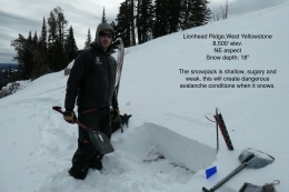
The tug-of-war between fall and winter continues with winter coming out on top this week. Tuesday’s storm came in warm with temperatures near or above freezing before cooling into the 20s F. This helped the new snow stick to the old snow surface. The weight of the 0.3 to 0.6” of snow water equivalent (SWE) did not significantly change the avalanche hazard. We received reports of fresh drifts of snow breaking in the Bridger Range, but nothing failed more deeply than the interface between the old and new snow (photo). Wind loaded slopes will stabilize by today. However, stronger wind over the weekend may create fresh drifts that could avalanche. The story from the Bridger Mountains applies to other ranges that received snow on Tuesday. The mountains south of Big Sky are different. Yesterday, Alex and I went to the Lionhead Range to work on the weather station where we found the weakest snow in our advisory area. The snowpack ranges from 6” to 18” deep and the lower portion consists of large, weak facets that will be a problem when West Yellowstone gets its next storm (photo 1, photo 2, video).
The snowpack will remain generally stable until the next storm comes on Sunday afternoon. We are working hard to get out in the field to collect information about the snowpack and we want you to help us by submitting an observation form. Your observations are critical to us developing a complete picture of what is happening in the mountains. You can also email us (mtavalanche@gmail.com), leave a message on our phone (406-587-6984) or Instagram (#gnfacobs).
Upcoming Avalanche Education and Events
Our education calendar is full of awareness lectures and field courses. Check it out and plan to attend one or two: Events and Education Calendar.
BOZEMAN
4 & 5 December, Introduction to Avalanche w/ Field Course, Evenings of December 4 & 5 plus one field day either December 7, 8 or 14. Snowmobile specific field day offered December 14. More info and Register Here.
HELENA
23 November, Helena Snowdrifters, Avalanche Awareness and Partner Rescue Training, 9am-3pm at the Mako Building in Helena.
It is two weeks until our first Introduction to Avalanches course with field sessions. Pre-register today!