Good Morning. This is Alex Marienthal with the Gallatin National Forest Avalanche Forecast on Sunday January 5th at 7:00 a.m. Today’s forecast is sponsored by Cooke City Motorsports and Spark R&D. This forecast does not apply to operating ski areas.
Yesterday afternoon a quick storm dropped 1-2” of snow near Bozeman, Big Sky and Cooke City. West-southwest wind was strong at 20-35 mph with gusts to 40-60 mph for most of yesterday. This morning west wind is 15-30 mph and temperatures are single digits to low teens F. Today, temperatures will be teens to low 20s F and wind will remain westerly at 15-30 mph. This afternoon light snow showers will begin with 2-4” possible near Cooke City and West Yellowstone, and 1-2” elsewhere by morning. More snow is expected tomorrow with highest amounts near Cooke City.

All Regions
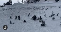
Yesterday on Buck Ridge near Big Sky three snowmobilers were caught in a very large avalanche that was 4-6 feet deep, 1500’ wide and broke on sugary snow at the bottom of the snowpack (photo, details). Two of them were partially buried to their waist. Luckily all were unharmed, but this could have been a tragedy. The last two days similar large avalanches were triggered and broke naturally on sugary, persistent weak layers deep in the snowpack. These include: The close call mentioned above, a natural slide on Saddle Peak, a natural on Yellow Mountain near Big Sky, and deep avalanches triggered by Big Sky and Bridger Bowl ski patrols during control work (photo, details and photos).
Today throughout the advisory area similar large, deadly avalanches are possible to trigger. See our photos page and avalanche activity log for a comprehensive look at the types of slides that are possible. Today the snowpack gets a break from loading by heavy snow and strong wind, and will slowly begin to stabilize. Avalanches breaking on persistent weak layers are becoming harder to trigger, but the consequences are high whether a slide is one foot or four feet deep.
Avalanches on these persistent weak layers can break wide and be triggered from lower angle terrain below or adjacent to steep slopes. Warning signs like collapsing or natural avalanches may not be present. Avoid slopes that are heavily wind loaded, identifiable by large overhanging cornices or big round pillows of snow, and avoid steep slopes where you suspect buried persistent weak layers.
Smaller avalanches can also break within drifts of recent snow, and are most hazardous where debris can pile deep or push you into trees or cliffs (photo). Travel on slopes protected from recent wind, and carefully assess the snowpack and terrain before riding on slopes steeper than 30 degrees. Today avalanches are possible to trigger and avalanche danger is MODERATE.
Upcoming Avalanche Education and Events
Our education calendar is full of awareness lectures and field courses. Check it out and plan to attend one or two: Events and Education Calendar.
COOKE CITY
Every Friday and Saturday, Snowpack Update and Rescue Training. Friday, 6:30-7:30 p.m. at the Soda Butte Lodge. Saturday anytime between 10-2 @ Round Lake.
WEST YELLOWSTONE
TONIGHT! January 4, 1-hr Avalanche Awareness, 7-8 p.m. at West Yellowstone Holiday Inn.
January 25, 1-hr Avalanche Awareness, 7-8 p.m. at West Yellowstone Holiday Inn.
BOZEMAN
January 7, Women's Specific Avalanche Awareness + Beacons, 6-8 p.m. at Story Mill.
January 8, 1-hr Avalanche Awareness, 6-7 p.m. at REI.
January 8, 1-hr Avalanche Awareness, Gallatin Valley Snowmobile Association Groomer Building.
January 10 & 11, Companion Rescue Clinic, 6-8 p.m. on the 10th at REI and 10-2 p.m. on the 11th at History Rock. More info and Register Here.
January 15 and 16, Introduction to Avalanche w/ Field Course, evenings of January 15 & 16 plus one field day either January 18, 19 or 25. Snowmobile specific field day offered January 25. More info and Register Here.
On New Year’s Day, two snowmobilers lost their lives in an avalanche near Seeley Lake, northeast of Missoula. Our condolences go out to their friends and families. The West Central Montana Avalanche Center has released a preliminary report.