Good Morning. This is Alex Marienthal with the Gallatin National Forest Avalanche Forecast on Monday, January 13th at 7:15 a.m. Today’s forecast is sponsored by Montana State Parks and Yellowstone Club Community Foundation. This forecast does not apply to operating ski areas.
Since yesterday morning new snow amounts range from zero in Hyalite to 12” in the mountains near West Yellowstone. The southern Madison Range and Cooke City got 4-7”, Big Sky got 3-5", and the Bridger Range got 3” near the ski area and 7-10” in the north. Overnight south-southwest wind increased to 15-30 mph with gusts of 30-50 mph. This morning temperatures are single digits to teens F and will remain cold today with highs in the teens F. Wind will shift westerly at 15-30 mph. Light snow is expected today with heavier snowfall overnight and tomorrow. By tomorrow morning 6-10” is possible near West Yellowstone and Cooke City with 2-4” elsewhere.

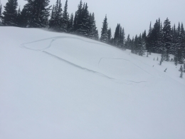
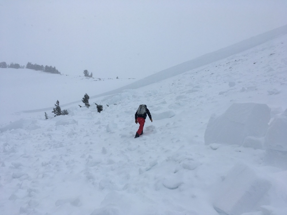
Over the last 24 hours the mountains near West Yellowstone and the southern Madison Range got 7-12” of snow equal to 0.7-1.2” of snow water equivalent (SWE). Snowfall was heaviest overnight and light snow will continue today. Moderate to strong southwest wind formed thick drifts that will grow larger today and overload buried weak layers (video). These drifts can easily be triggered and can break deeper and wider on sugary snow near the ground (photo, photo). Even without wind-loading the new snow is enough to create slabs that can avalanche and be large enough to bury or injure a person. Today all steep slopes and runout zones should be avoided. Dangerous avalanche conditions exist and avalanche danger is CONSIDERABLE.
Near Cooke City, Big Sky and the Bridger Range strong southwest wind last night created fresh drifts that are easy to trigger. These mountains received 3-7” of snow yesterday, and over 20” in the last week. Today moderate westerly wind will continue to grow drifts. Steep wind-loaded slopes should be avoided. Watch out for round pillows of snow and slopes below large cornices.
A less likely, but certainly deadly avalanche can be triggered on weak layers buried near the bottom of the snowpack. Yesterday Doug went to Buck Ridge and saw three avalanches that broke on weak layers near the ground (video). Dave was in Cooke City where the 40”+ of snow that fell since the beginning of 2020 was the main avalanche concern, and he emphasized the possibility of larger avalanches breaking deep in the snowpack (video). Wind loaded or not, avoid any steep slope with suspected buried weak layers. See our videos and photos to get a better idea of where these weak layers exist in the snowpack. Avalanche danger is CONSIDERABLE on wind loaded slopes and MODERATE on non-wind loaded slopes.

The northern Gallatin Range did not get any snow over the last 24 hours and has a generally stable snowpack. On Saturday I toured to Mt. Blackmore and the main avalanche concern was fresh drifts of snow (video). These mountains received 10-15” of snow last week. Strong wind last night drifted this snow into fresh slabs that are possible to trigger. Watch for cracking of the snow surface as a sign fresh drifts are unstable, and carefully assess consequences of an avalanche before riding steep slopes. Avalanche danger is MODERATE on wind loaded slopes and LOW on non-wind loaded slopes.
If you get out, please send us your observations no matter how brief. You can fill out an observation form, email us (mtavalanche@gmail.com), leave a VM at 406-587-6984, or Instagram (#gnfacobs).
Webpage dedicated to the Centennial Range in Idaho and Montana
After the two snowmobiler avalanche fatalities on Reas Peak in the Centennial Range in January 2018 we created a webpage so riders could get good, relevant information regarding snowpack and avalanches. Although the Centennial Range is not part of the Gallatin National Forest Avalanche Center's forecast area, we are the closest avalanche center and have valuable information to share. More…
Upcoming Avalanche Education and Events
Our education calendar is full of awareness lectures and field courses. Check it out and plan to attend one or two: Events and Education Calendar.
COOKE CITY
Every Friday and Saturday, Snowpack Update and Rescue Training. Friday, 6:30-7:30 p.m. at the Soda Butte Lodge. Saturday anytime between 10-2 @ Round Lake.
BOZEMAN
January 15 and 16, Introduction to Avalanche w/ Field Course, evenings of January 15 & 16 plus one field day either January 18, 19 or 25. Snowmobile specific field day offered January 25. More Info and Register Here.
January 27, Avalanche Information and Demonstration Table, 10 a.m. to 12 p.m. at Montana Science Center.
January 29, GNFAC Forecaster Chat: Avalanche Myth Busters, 6-8 p.m. at Uphill Pursuits.
January 31, Women’s Only Companion Rescue Clinic, 6 - 8 pm at REI followed by a field day February 1. More info and Register Here.
February 1, King and Queen of the Ridge at Bridger Bowl (fundraiser). This is the Friends of the Avalanche Center’s second biggest fundraiser of the year. Come on out and help us raise money by hiking and skiing laps on the ridge. Prizes, camaraderie and a good time is guaranteed. Register with Bridger to hike in the event, and create a pledge page to raise funds with your Ridge laps.
BUTTE
January 15, 1-hr Avalanche Awareness, 7-8 p.m. at 5518 Designs.
DILLON
January 15, 1-hr Avalanche Awareness, 7-8 p.m. at University of Montana Western.
January 29 and 30, Introduction to Avalanche w/ Field Course, evenings of January 29 & 30 plus a field day February 1. Snowmobile specific field day offered February 2. More Info and Register Here.
WHITEHALL
January 18, 1-hr Avalanche Awareness, 10 a.m. to 12 p.m. at Homestake Lodge.
WEST YELLOWSTONE
January 25, 1-hr Avalanche Awareness, 7-8 p.m. at West Yellowstone Holiday Inn.
February 1, 1-hr Avalanche Awareness, 7-8 p.m. at West Yellowstone Holiday Inn.
HELENA
January 28, 1-hr Avalanche Awareness, 6-7 p.m. Carroll College.
LIVINGSTON
January 30, Introduction to Avalanche w/ Field Course, evening of January 30 plus a field day February 2. More info and Register Here.
“Likelihood is not Danger”. See this recent blog from the Flathead Avalanche Center discussing how potential size and consequences of avalanches can determine our travel advice.