Good Morning. This is Dave Zinn with the Gallatin National Forest Avalanche Forecast on Tuesday, March 24th at 7:00 a.m. Today’s forecast is sponsored by World Boards and Highline Partners.
Bridger parking lots are private property. Please do not loiter, camp overnight or congregate in the parking lots. Skin, ski, leave. The lots will be closed if people do not respect this request. Ski areas are closed and backcountry conditions exist. There is no avalanche control or ski patrol services (video).
Social Distancing in the Backcountry
We hope all can enjoy the outdoors to ease the stress during this challenging time, and we will continue regular avalanche forecasts into April. It is important we all do our part to reduce the spread of COVID-19 in our community. While you are in parking lots and on trails please practice social distancing and other precautions recommended by the city, county and nation (video from county health department). Please do not carpool with people outside your household, keep groups small and don’t have social gatherings in the parking lot (with dogs as well). You can stay up-to-date on COVID-19 in Montana and globally on the Montana Department of Health and Human Services website. Be patient and courteous. Step aside for other groups to pass. Smile, say hi and communicate, “go ahead” and “thank you”. Dial back your objectives and slow down to minimize the risk of injury and overtaxing local EMS services. Help each other and stay safe. Thank you.
This morning the mountains received 1-3” of new snow with temperatures in the 20s F. The winds are blowing 10-20 mph with gusts around 40 mph from the west to southwest. Snow will continue today and tonight with 4-6” in the mountains near Bozeman, Big Sky and Cooke City and 2-4” near West Yellowstone by morning. Winds will be 15-25 mph from the west to the southwest before dying down this evening and temperatures will be in the upper 20s to mid-30s F.

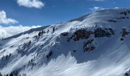
All Regions
One to three inches of new snow fell across our advisory area with moderate winds predominantly from the southwest. This weekend skiers near Big Sky triggered small avalanches where the wind had drifted snow (photo and details, photo). In steep terrain avalanches like this could easily push you into or off obstacles such as trees, gullies and cliffs. Look for cracks extending from your skis or sled to indicate this instability. If you find it, move to another area. While not ubiquitous, several groups have found surface hoar, a new weak layer, buried under the new snow (photo). Skiers near Big Sky and Cooke City have identified this layer on some slopes but not others. Dig down a couple of feet and look for a stripe in your snowpit wall and propagation in your stability tests. The wind will also continue to build cornices and are ripe for collapse (photo). The cornice collapse alone is dangerous, but it could also be the trigger that initiates a deeper avalanche such as one outside our advisory area in the Absaroka Mountains on Friday (photos and details).
Dry snow avalanches breaking near the surface will be our primary concern today. However, wet snow avalanches and deep slab avalanches should be on your radar. Cooler temperatures and snow will minimize wet snow avalanches at high elevations, but if snow turns to rain at lower elevations the snowpack will quickly become unstable and it is time to move on. After several weeks of relative quiet, on Friday two separate groups of skiers south of Livingston (outside our advisory area) unintentionally triggered avalanches failing on deeply buried weak layers. The same day, unstable test results on sugary depth hoar drove our decision to turn around before arriving at our objective in the Taylor Fork (video). An avalanche on this layer is unlikely but dangerous. The most likely ways to trigger this unlikely event are to find an area where the snowpack is thin or to be in the area when a cornice falls.
The avalanche danger is MODERATE on wind-loaded slopes and LOW on non-wind-loaded slopes. Assess the stability of the new snow, limit your time underneath cornices and take a couple of steps back in order to minimize stress on an already taxed medical system.
We will end daily avalanche forecasts on April 5th and continue with general bulletins every Monday and Friday through April. Over the next couple of weeks, we will take down weather stations and will no longer receive observations from guides and ski patrols. We need help gathering field data. Please send us your observations no matter how brief. You can fill out an observation form, email us (mtavalanche@gmail.com), leave a VM at 406-587-6984, or Instagram (#gnfacobs).
The Friends of the GNFAC provides free and low-cost avalanche education in Southwest Montana (and beyond). This year our fantastic group of instructors reached OVER 4000 individuals with our programs!
Thank you to our team and thank you to everyone in the community for valuing safe backcountry recreation!
You can find courses offered by other providers on our website on the Events and Education Calendar.
To slow the spread of novel coronavirus do the FIVE: 1) HANDS Wash them often. 2) ELBOW Cough into it. 3) FACE Don't touch it. 4) SPACE Keep safe distance. 5) HOME Stay if you can.