Good Morning. This is Dave Zinn with pre-season avalanche, weather and event information for the Gallatin National Forest Avalanche Center on Friday, December 4th at 7:30 a.m. This information is sponsored by Highline Partners and Spark R&D. We will issue our next bulletin when conditions change.
*Note: Bridger Bowl Ski Area is closed and there is no avalanche control or ski patrol services. Backcountry conditions exist. Workers are setting up for the season and making snow. Please stay clear of work areas, snow guns, chair lifts and other equipment.
Monday and Tuesday, the Bridger Range and Cooke City received 6 to 8” of new snow with the rest of the advisory area getting 2-3”. Currently, winds are averaging 25 MPH in the Bridger Range from the west and 10 MPH elsewhere from the west to the north with temperatures in the upper 20s F.
This weekend, skies will be clear with 5-15 MPH winds and mountain temperatures in the 30s F. The next chance of snow arrives in the middle of next week.

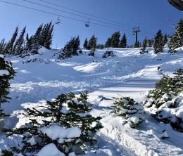
The Bridger Range received 6-8” of new snow earlier this week with winds creating drifts that avalanched naturally and with human triggers. Two to three inches of new snow in the Gallatin, Madison, and Lionhead areas fell onto a similarly weak foundation but with less wind. Wednesday, skiers triggered an avalanche under the Slushman’s Lift that forced hikers below to scamper out of the way to avoid getting hit by the slide (photo). The same day, Big Sky Ski Patrol triggered a hard slab avalanche while performing avalanche mitigation work. Thursday, Bridger Bowl Ski Patrollers working on preseason setup noted a natural avalanche in Sluice Box. In the Bridger Range, strong winds continue to move the lessening supply of fresh snow into drifts. Stay off of hollow feeling slabs of hard snow and watch for cracks coming from your skis as indicators of continued instability.
Calming winds this weekend and less soft snow to transport will allow the snowpack to stabilize and avalanches will be harder to trigger. The theme in all these areas is a thin and weak snowpack that will avalanche when loaded by new snow or wind (Lionhead video, Beehive video). Assess slopes for a slab of cohesive snow on top of weak, sugary snow by digging with your shovel, hand, or sled track. If you find this setup, move to lower angle terrain or a different slope to play on.
The mountains around Cooke City received up to 10” of new snow on Monday with light wind. While this fell on a generally stable snowpack, the story is now more complicated because it buried a weak layer of surface hoar and facets in some locations (video). These areas are potential landmines. We are working to understand how widespread this weak layer is and you should too if you are riding or skiing in the area. Dig down a few feet and perform an extended column test before committing to any steep terrain. If your test breaks across the column, look for a different slope or stay in lower angle terrain. We are cautiously optimistic that we did not receive reports of significant avalanche activity after the storm. As time passes without new snow, conditions will continue to stabilize. Don’t let your guard down as even a small avalanche can have significant consequences.
Every day we will update the weather log, photos page and avalanche activity list. We will continue issuing early season updates and transition to daily avalanche forecasts when we get more snow. If you have avalanche, snowpack or weather observations to share, please submit them via our website, email (mtavalanche@gmail.com), phone (406-587-6984), or Instagram (#gnfacobs).
Upcoming Avalanche Education and Events
See our education calendar for an up to date list of all local classes. Here are a few select upcoming events and opportunities to check out:
Every Saturday in Cooke City, FREE snowpack update and rescue practice at the Round Lake Warming Hut between 10 a.m. and 3 p.m. Starts this Saturday, November 28. Poster with More Info.
Monday, December 7, 6-7 p.m., FREE SNOWMOBILE SPECIFIC online 1-hr Avalanche Awareness sponsored by Blitz Motorsports. Join HERE.
December 7-8: Intro to Avalanches w/ Field in West Yellowstone. The 7th is online lectures from 1-5 p.m. and separate snowmobile and ski field days on the 8th. Info and sign up is HERE.
Tuesday, December 15, 6-7 p.m., FREE online 1-hr Avalanche Awareness sponsored by Uphill Pursuits.
Monday, December 21, 6-7 p.m., FREE online 1-hr Avalanche Awareness sponsored by Mystery Ranch. Join HERE.
The December Avalanche Fundamentals with Field Course has SOLD OUT, but there will be a second course on January 23 and 24. There are separate field sessions tailored for both skiers and splitboarders (Bridger Bowl) and snowmobilers (Buck Ridge).
Doug spoke with the Last Best Ski Podcast about avalanche fundamentals, some climbing history, and the workings of the GNFAC. The 25-minute podcast is available here.
Support the Friends of the GNFAC
This year, The Friends of the Avalanche Center are unable to host an in-person Powder Blast due to COVID. In place of their biggest fund-raiser, the Friends of GNFAC launched an online GoFundMe campaign. Please consider a donation, and we look forward to having an in-person event again in the future.
The Friends of the Avalanche Center are encouraging everyone to take an avalanche class. Look at our Education Page for all the classes being offered in sw Montana. They are working hard to break down Backcountry Barriers and made this awesome 6 min video about it.