Good Morning. This is Doug Chabot with the Gallatin National Forest Avalanche Forecast on Thursday, January 21st at 7:00 a.m. Today’s forecast is sponsored by Uphill Pursuits and Cooke City Super 8/Bearclaw Bob’s. This forecast does not apply to operating ski areas.
At 5 a.m. skies are partly cloudy, wind is westerly at 10-20 mph with gusts of 30 mph and mountain temperatures are in the high teens. Today, clouds will increase and snowfall will start later this afternoon with light westerly wind and temperatures of 20F. By tomorrow morning there will be 3-4” of new snow in the northern areas and 2-3” in the southern ranges. The storm will end early tomorrow morning and the weekend looks to be sunny.

The wind is decreasing and there has not been new snow since Monday. The snow from the Bridger Range south to West Yellowstone has a weak structure. There are two layers in the snowpack to be concerned about, one thin and one thick. The thin layer is feathery crystals of surface hoar buried a foot under the surface (photo). The thicker layer is sugary, weak grains at the bottom 1-2 feet of the snowpack. Both of these layers are weak and could be triggered.
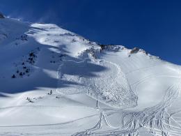
On Monday and Tuesday snowmobilers triggered slides in Tepee Basin (photos and details) and Buck Ridge (2nd Yellowmule photo). And on Tuesday skiers saw a recent avalanche on the north face of Mt. Blackmore (photo). The thick layer of weak snow underlying the bottom third of the snowpack is on most slopes. The thin layer of surface hoar is not everywhere, but it’s a good idea to assume it is since we don’t know it’s exact location. This was my advice in Monday’s video and it still holds true today.
These recent avalanches coupled with skiers still getting collapses/whumpfs, plus poor stability test scores, are signs of the snowpack’s chronic instability. Triggering avalanches is still possible today and the danger is rated MODERATE on all slopes.
The mountains around Cooke City have two weak layers to be concerned about. The first is an inch thick layer of feathery crystals (surface hoar) that is buried 12-18” deep. On Tuesday, a group of snowmobilers triggered this layer in Sheep Creek, and 2 small slides in Goose Creek broke on this layer the same day (details and photo). The second is a thin layer of faceted grains buried 3 feet deep. Both of these layers are scattered and not on every slope. Dave was in Cooke City on Sunday and Monday and recommends either assuming these layers are everywhere, or assessing slopes carefully by digging and testing (video, video). Without new snow or wind-loading triggering avalanches is more difficult, but still possible. Because of buried weak layers and avalanche activity as recent as 48 hours ago, the avalanche danger is rated MODERATE on all slopes.
If you get out, please send us your observations no matter how brief. You can submit them via our website, email (mtavalanche@gmail.com), phone (406-587-6984), or Instagram (#gnfacobs).
Upcoming Avalanche Education and Events
See our education calendar for an up-to-date list of all local classes. Here are a few select upcoming events and opportunities to check out:
Every Saturday in Cooke City, FREE snowpack update and rescue practice at the Round Lake Warming Hut between 10 a.m. and 3 p.m. Poster with More Info.
A snowboarder was caught in an avalanche in Colorado last week and caught it on video.