Good Morning. This is Doug Chabot with the Gallatin National Forest Avalanche Forecast on Wednesday, March 24th at 7:00 a.m. Today’s forecast is sponsored by Blitz Motorsports and Yamaha and Montana Chevy Dealers. This forecast does not apply to operating ski areas.
Early yesterday morning 1-2” fell around Bozeman and Big Sky before the storm ended. This morning skies are clear, mountain temperatures are in the single digits and wind is west to southwest at 10-20 mph with gusts of 35 mph in the Bridger Range. Wind will remain the same and skies will cloud up this afternoon with temperatures reaching the mid-thirties F. Snow showers tonight will drop 1-2” by morning.

The Bridger Range was windy last night with gusts out of the west at 35 mph. A foot and a half of snow that fell since Friday is getting blown into drifts. Yesterday, small wind slabs avalanched with ski cuts. Today, these drifts will be thicker, wider and more significant. On some slopes these wind slabs are sitting on a thin layer of weak, faceted snow which could be triggered from below and travel further than expected. The interplay of loose snow, wind and a weak layer are creating dangerous avalanche conditions. Avoid all wind-loaded terrain where the avalanche danger is rated CONSIDERABLE. All other slopes have a MODERATE danger.

In the mountains south of Bozeman to Big Sky, West Yellowstone and Cooke City, the avalanche potential revolves around two problems:
- Fresh snow since Friday (1.5-2 feet) is getting blown into thicker drifts at the ridgelines. Dave and I saw this yesterday on Mount Blackmore and were able to get wind drifts to crack. Gusty wind today will thicken them even more. Yesterday, two skiers retreated out of a couloir up Hyalite when they triggered a small 6-inch thick avalanche. They noted that wind would make things worse (photo and details).
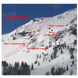
- Underneath the new snow since Friday is a very thin layer of weaker snow (near-surface facets). Its distribution is spotty which makes finding it problematic. Doggedly dig and test to be confident it is not underfoot. Since the layer is not buried deep, digging and testing can be done quickly, in about a minute (video). Dave and I hunted for it yesterday and did not find it in our 4 snowpits (video), although we know it’s in the neighborhood. On Sunday, skiers triggered it on another slope on Mount Blackmore (details) and a party was caught in a slide when they triggered it from below on Alex Lowe Peak (details). We also found this layer in McAtee Basin, the Bridger and Centennial Ranges, and Cooke City.
Dig shallow and frequent snowpits to hunt for this weak layer. If you find it, stay out of nearby avalanche terrain. Furthermore, be cautious near the ridgeline where wind drifts are growing thicker and could be triggered. Today the avalanche danger is rated MODERATE on all slopes.
If you get out, please send us your observations no matter how brief. You can submit them via our website, email (mtavalanche@gmail.com), phone (406-587-6984), or Instagram (#gnfacobs).
Upcoming Avalanche Education and Events
See our education calendar for an up-to-date list of all local classes. Here are a few select upcoming events and opportunities to check out:
TONIGHT! 6 p.m., Free 1-Hour Avalanche Awareness, online Link to Join HERE
March 29, 6 p.m., Free 1-Hour Avalanche Awareness, online Link to Join HERE
April 5, 6:30 p.m. Forecaster Chat with Alex Marienthal, hosted by Uphill Pursuits, “Spring Snowpack and Forecasting Tools”.
Yesterday, a skier was caught and killed by an avalanche in the backcountry near Beaver Creek Ski Area (preliminary information and photos). Saturday, a snowmobiler died when he stepped off his sled, broke a large cornice, and triggered an avalanche below (details and photos). We are sad to hear of these losses. Please continue to follow safe travel protocols, assess the snowpack, and come home at the end of a good day in the mountains.