Good morning. This is Alex Marienthal with the Gallatin National Forest Avalanche Forecast on Sunday, January 2nd at 7:00 a.m. This information is sponsored by Werner Wealth Management (Advisors with DA Davidson), Montana Backcountry Alliance, and Yellowstone Ski Tours. This forecast does not apply to operating ski areas.
This morning there is no new snow. Temperatures are single digits to low teens F near Bozeman and Big Sky, and below zero F near West Yellowstone and Cooke City. Yesterday in the Bridger Range west wind was 30 mph with gusts to 45 mph. Overnight, throughout the advisory area westerly wind was 25 mph with gusts of 30-45 mph. Today will be partly cloudy with temperatures reaching low teens to low 20s F. West-southwest wind will be 10-25 mph this morning and will increase to 30-45 mph this afternoon. The next round of snow is expected tomorrow night.

Today riders or skiers can trigger avalanches that break within or below snow that fell over the past couple weeks (4-5 ft of snow over 10 days). These large and potentially deadly avalanches have become more difficult to trigger, but we are not ready to trust persistent weak layers buried below the recent snow (Lionhead video, Cooke City weekly update). Be cautious of wind-loaded slopes, especially those loaded during the recent storm, or where you see snow being drifted into fresh slabs today. Human triggered avalanches are possible and the avalanche danger is MODERATE.
Large avalanches on Saddle Peak over the last few days are a sign that avalanches can be triggered today (details, photo, photo). Yesterday we went to get a look at these slides and saw that over the last week wind has drifted snow into slabs on top of weak, faceted snow (video). Strong west winds yesterday were growing fresh soft slabs which broke easily under our skis (photo), and skiers near Bradley’s Meadow reported one of these slabs avalanching naturally off the ridge (photos and details). Consider staying off steep, wind-loaded slopes today, especially if you see wind continuing to grow drifts (photo). If you choose to ski or ride steep slopes, carefully assess the snowpack for instability, and recognize the consequences if the slope were to slide. Today avalanches are possible to trigger and avalanche danger is rated MODERATE.

The snowpack is mostly stable in the northern Gallatin and Madison Ranges and large avalanches are unlikely. Today you might find an isolated, unstable drift of snow. A few of these small wind slabs may form if winds increase this afternoon. Be cautious of steep slopes where terrain traps below create high consequences of being caught in a slide. Keep in mind the potential for fresh, unstable wind slabs to form with increased wind later today. If you see a lot of drifting snow or cracking around your skis in fresh drifts, consider finding less steep or non-wind loaded terrain. Today large avalanches are unlikely and avalanche danger is LOW.
If you get out, please send us your observations no matter how brief. You can submit them via our website, email (mtavalanche@gmail.com), phone (406-587-6984), or Instagram (#gnfacobs).
Upcoming Education Opportunities
Get your avalanche brain ready for the season at one of the many classes listed on our education calendar, and list of upcoming events below.
January 20 + Field day. Our popular Avalanche Fundamentals with Field Course is perfect as a refresher or an introduction to avalanches. We are introducing a new format with four pre-recorded lectures to watch at your convenience, a live question and answer session, and a choice of a snowmobile or ski/ board based field day occurring the following two weekends.
Every Saturday near Cooke City, 10 a.m.-3 p.m. FREE snowpack update and transceiver/rescue training. Stop by for 20 minutes or more at the Round Lake Warming Hut.
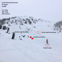
On Monday, December 27th, two snowmobilers were caught and killed in an avalanche on Scotch Bonnet Mountain, north of Cooke City. We have completed our report, which is available HERE.