Good morning. This is Dave Zinn with the Gallatin National Forest Avalanche Forecast on Monday, February 14th, at 7:00 a.m. This information is sponsored by our Valentines. You all are the best. This forecast does not apply to operating ski areas.
This morning, mountain temperatures are in the mid-teens to mid 20s F with 10-20 mph winds from the west to southwest, and there is no new snow. Today, temperatures will climb into the low 30s to low 40s F with southwest winds blowing 10-15 mph. Our on-again-off-again relationship with winter will take a turn for the snowier tonight with 3-5” falling by morning in the mountains near Bozeman and Big Sky and 1-2” elsewhere in the advisory area.

It is possible to trigger avalanches 1-2 feet deep in the mountains around Cooke City. Avalanches this weekend indicate that buried weak layers of facets and feathery surface hoar aren’t to be fully trusted. Saturday, riders triggered an avalanche that broke 2’ deep and 30’ wide on a north-facing slope and a group saw a skier-triggered slide north of Silver Gate (Silver Gate photo and details). On Friday, a cornice collapse triggered a slope just south of Cooke City (Wyoming Creek photo and details). Significant wind-loading late last week added stress to the snowpack and slopes with recent drifts are more likely to be unstable. Evaluate the snowpack and terrain carefully and turn around if you observe cracking, collapsing or recent avalanches. Finally, get your shovel in the snow to test the upper few feet of the snowpack before committing to avalanche terrain. The danger is MODERATE.

While conditions are generally safe in mountains around Bozeman, Big Sky and West Yellowstone, Doug mentioned yesterday that “it is not a turn your brain off type of low danger.” Isolated areas of instability exist due to buried weak layers and small drifts of snow. Yesterday, Doug and his partner skied into the wilderness area in the Taylor Fork. They got an unstable test result on a buried weak layer that caused them to change their minds about skiing in avalanche terrain (video). He still felt like triggering an avalanche would be unlikely, but the risk wasn’t worth it for them. Getting this information is why we dig and test the snowpack. On Saturday, Alex saw a recent avalanche on Cedar Mountain on a wind-loaded slope during a ride at Buck Ridge (video, photo).
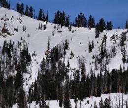
Yesterday, small, wet snow avalanches occurred on isolated slopes in the Bridger Range. These are less likely today with increasing cloud cover but worth having on your radar if skies are clear and sunny during the heat of the day (photo).
Follow standard avalanche safety protocols, watch for unstable snow on isolated terrain features and remember that small slides are dangerous when combined with terrain traps. The avalanche danger is rated LOW.
If you get out, please send us your observations no matter how brief. You can submit them via our website, email (mtavalanche@gmail.com), phone (406-587-6984), or Instagram (#gnfacobs).
Upcoming Education Opportunities
See our education calendar for an up-to-date list of all local classes. Here are a few select upcoming
February 19, Women’s only Companion Rescue Clinic sponsored in partnership with SheJumps! Register Here.
March 4, Companion Rescue Clinic with the Bozeman Splitfest. Information and registration HERE.
Every Saturday near Cooke City, 10 a.m.-3 p.m. FREE snowpack update and transceiver/rescue training. Stop by for 20 minutes or more at the Round Lake Warming Hut.
A detailed report on the avalanche fatality at Ski Hill in Lionhead is HERE, a video summary is on our YouTube channel and the incident is recorded on our Accident Reports page.