Good morning. This is Doug Chabot with the Gallatin National Forest Avalanche Forecast on Thursday, February 24, at 6:45 a.m. This information is sponsored by Grizzly Outfitters and Highline Partners. This forecast does not apply to operating ski areas.
Avalanche Fatality Report
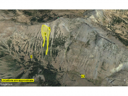
A detailed report on Saturday’s avalanche that killed a snow biker outside Cooke City is posted online. The video describing the avalanche can be viewed here.
This morning there is no new snow, mountain temperatures are around -5 F and wind is west at 10-20 mph with gusts of 35 mph. Today will be mostly cloudy, wind speed will continue to be light to moderate out of the west and temperatures will rise into the high single digits. The mountains will get a few flurries today with the southern ranges near West Yellowstone and Cooke City getting 1-2” of snow by morning.

In the mountains around Cooke City there is a weak layer of faceted, sugary snow a couple feet under the surface. There were recent avalanches on this layer (Miller Mountain, Mount Abundance, Round Lake) and red flags of collapsing and cracking, plus poor stability test scores yesterday south of town on Woody Ridge. This weak layer is getting difficult to trigger, but it is widespread and demands our attention. Cracking and collapsing are signs that the snowpack is unmistakably unstable and poor stability test scores are a proxy to that. Triggering avalanches is possible today, so travel accordingly. In light of our recent accidents it’s wise to travel one at a time in avalanche terrain, watch each other from a safe distance and carry rescue gear. For today the avalanche danger is rated MODERATE.

From the Bridger Range to Big Sky and West Yellowstone, the snowpack is generally stable and triggering avalanches is unlikely. This does not mean the snowpack cannot surprise us; it merely means the odds are in our favor. There are two things to keep in mind with the snowpack today. The first are wind-drifting in odd places from the strong east wind that blew the last 3 days. The wind scraped slopes that normally get loaded and chewed back cornices, moving snow to slopes that are normally scoured (photo). Skiers on Mt. Ellis reported this yesterday. The second concern is weak, faced snow about 6-18” under the surface. Overall this layer is not reactive, but there may be a few small slopes with lingering instability that could be triggered. Look no further than the avalanche fatality in Lionhead on February 7 as a reminder of the deadly potential of a small, isolated slide.
Always be on the lookout for signs of instability, and now that it’s getting warmer, stopping and testing the snow is no longer a frostbite threat. For today the avalanche danger is rated LOW.
If you get out, please send us your observations no matter how brief. You can submit them via our website, email (mtavalanche@gmail.com), phone (406-587-6984), or Instagram (#gnfacobs).
Upcoming Education Opportunities
See our education calendar for an up-to-date list of all local classes. Here are a few select upcoming events.
March 4, Companion Rescue Clinic with the Bozeman Splitfest. Information and registration HERE.
Every Saturday near Cooke City, 10 a.m.-3 p.m. FREE snowpack update and transceiver/rescue training. Stop by for 20 minutes or more at the Round Lake Warming Hut.
A detailed report on Saturday’s avalanche that killed a snow biker outside Cooke City is posted online. The video describing the avalanche can be viewed here.