Good morning. This is Dave Zinn with the Gallatin National Forest Avalanche Forecast on Wednesday, March 2nd, at 7:15 a.m. This information is sponsored by Advanced Innovation, Klim and Gaia GPS. This forecast does not apply to operating ski areas.
This morning temperatures are in the mid 20s F in the mountains around West Yellowstone and Cooke City and in the low 30s F near Bozeman and Big Sky. Winds are 15-20 mph from the west to southwest and there is 1-3” of new snow in the mountains near Cooke City and Big Sky. Today, high temperatures will be in the mid 30s to mid 40s F with 10-15 mph west to southwest winds. Cooke City may get a trace of new snow by morning.
As we noted in Beehive Basin yesterday, a mixed bag of weather including strong winds, light snow, light rain and warm temperatures, brings a mixed bag of avalanche problems to the mountains around Bozeman, Big Sky and West Yellowstone (video). Keep your senses keen for changing conditions and signs of instability associated with wind-loading, wet snow and persistent weak layers.
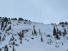
- Recently winds loaded slopes with large drifts could avalanche. In the Bridger and Northern Gallatin Ranges this weekend, skiers and riders triggered avalanches breaking up to several hundred feet wide and 18” deep, small slides and shooting cracks (avalanche activity list). On Monday, Doug and his partner got brutalized by the wind to make a video telling us that wind-loading is a problem. Listen to his advice and avoid wind-loaded slopes.
- Wet snow avalanches are a concern where the snowpack did not freeze last night and there was light rain yesterday (primarily the Bozeman and Big Sky areas). The snow will continue to weaken and wet snow avalanches will become more widespread with continued warm temperatures. Recognize increasing danger if you are sinking into unsupportable wet or slushy snow.
- A weak layer of facets buried 6-18” deep will exacerbate the above issues. This layer could result in localized instability on its own, especially where there is more new snow. Dig and test the snowpack for these layers.
Plenty of safe skiing and riding exists. However, stay heads up for changing conditions, signs of instability and utilize safe travel practices. The danger is MODERATE.
The mountains around Cooke City received 5” of new snow equal to 0.5” of snow water equivalent in the last 48 hours and moderate winds are transporting snow onto slopes with weak layers buried around 2’ deep. Yesterday, a group of skiers near Goose Creek triggered an avalanche that broke 60’ wide and 12-16” deep on these weak layers. The skier lost a ski in the debris but was otherwise unharmed (photos and details). Riders and skiers triggered five other avalanches that we know of last weekend and Alex triggered a “whumph” on Sunday, indicating unstable snow (avalanche activity list, video). Larger avalanches like that on Mount Abundance last week are less likely but remain possible (video).
Today, if you observe signs of instability, get unstable test scores or see a poor snowpack structure, make more conservative terrain choices. Human-triggered avalanches are possible and the danger is MODERATE.
If you get out, please send us your observations no matter how brief. You can submit them via our website, email (mtavalanche@gmail.com), phone (406-587-6984), or Instagram (#gnfacobs).
Upcoming Education Opportunities
See our education calendar for an up-to-date list of all local classes. Here are a few select upcoming events.
March 4, Companion Rescue Clinic with the Bozeman Splitfest. Information and registration HERE.
Every Saturday near Cooke City, 10 a.m.-3 p.m. FREE snowpack update and transceiver/rescue training. Stop by for 20 minutes or more at the Round Lake Warming Hut.
Sadly, in Colorado, last Friday, a group of four snowshoers and two dogs triggered an avalanche from an unmaintained road in a creek drainage that caught three people and both dogs. One person and both dogs lost their lives (preliminary information here). Our deepest condolences to the survivors and family and friends.


