Good morning. This is Doug Chabot with the Gallatin National Forest Avalanche Forecast on Wednesday, March 23rd at 7:00 a.m. This information is sponsored by onX and Grizzly Outfitters. This forecast does not apply to operating ski areas.
At 5 a.m. skies are mostly clear with westerly wind averaging 10-15 mph and gusting to 30 mph (25-38 mph in the Bridger Range). Freezing level is around 7,000’ and temperatures at 9,000’ are in the mid 20s F. Today will be sunny, wind will be light and mountain temperatures will reach the mid 40s as the freezing level rises to 10,000’ before dropping again tonight. Shorts and flip-flop sightings will increase today along with sunburn potential.

All Regions
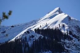
Listen up. The snowpack will undergo quick and dramatic change today in both aspect and elevation as temperatures rise well above freezing in the mountains. On slopes getting direct sunshine the surface will soften quickly and we will see many wet loose avalanches. On low elevation slopes where the snow did not freeze overnight we may get wet slab avalanches. At high elevations, winter is still entrenched on northerly facing, colder aspects and dry snow avalanches could still be triggered. Yesterday, Ian and I checked out a large slide in Sunlight Basin in Taylor Fork that was likely triggered a few days ago (video). Dave skied above Hebgen Lake near West Yellowstone and found very weak, wet snow down low and dryer weak snow up high (video). Throughout our forecast area we have weak layers of faceted snow buried 1-3 feet deep that will be under a new type of stress from high temperatures.
Today, all sorts of changes are happening in the snowpack that are difficult to see or measure: bonds in between individual snow grains melt, creep accelerates, free water can flow, pool and break along crusts. Yada, yada, yada. It’s impossible to wrap our heads around it all so I recommend sticking to the basics because they always work.
- Sinking into boot-top deep wet snow means wet snow avalanches are likely.
- Pinwheels and roller balls increasing in size as they roll downhill mean the surface is wet enough to avalanche.
- Any avalanche, wet or dry, is a sign that more, bigger slides are possible.
- Cornices are likely to break and trigger slopes below them.
I have a high level of uncertainty on how the snowpack will respond to sunny skies and above freezing temperature. Today is a day to be extra alert because conditions and avalanche danger may change fast. Avalanches, both wet and dry, slab or loose, are possible and the danger is rated MODERATE, but it’s not like yesterday’s moderate, it’s a different beast.
If you get out, please send us your observations no matter how brief. You can submit them via our website, email (mtavalanche@gmail.com), phone (406-587-6984), or Instagram (#gnfacobs).
Upcoming Education Opportunities
See our education calendar for an up-to-date list of all local classes. Here are a few select upcoming events and opportunities to check out:
THURSDAY, March 24, 6:30-7:30 p.m., 1-hour FREE lecture, Know Before You Go: Women’s Avalanche Awareness, Uphill Pursuits, Bozeman. More information HERE.
On March 19, two skiers were caught and one was killed in an avalanche near Steamboat Springs, Colorado (preliminary details). This was the fourth avalanche fatality in the U.S. in the past week and the fifteenth this season (https://avalanche.org/avalanche-accidents/).