Good morning. This is Doug Chabot with the Gallatin National Forest Avalanche Forecast on Thursday, March 31st at 7:00 a.m. This information is sponsored by onX and Uphill Pursuits. This forecast does not apply to operating ski areas.
At 6 a.m. light snowfall has dropped a trace to 1” of snow in the mountains. Temperatures are in the mid 20’s F and ridgetop wind is 5-15 mph with gusts of 20-30 mph from the southwest to northwest. Today will be cloudy with scattered snowfall measuring 1-3” by tomorrow morning. Temperatures will rise to the mid-30s F and wind will continue to be light to moderate from the west-southwest.

All Regions
Temperatures are below freezing and skies will remain cloudy, effectively shutting down melting and wet avalanche activity. The snow that is falling will total a few inches and may slide as loose sluffs on steep slopes. However, the main concern is not avalanches, but ski injuries from the new snow covering up the frozen surface, described as skiing on a coral reef.
In the last week the snowpack has changed. Meltwater has percolated into layers and many slopes have moist, mushy snow. The buried layers, even dry ones, are warming and getting close to zero degrees Celsius. At this temperature liquid water moves through the snowpack and weakens it quickly. We see this when we sink to our waist in wet snow after stepping out of our skis or off our snowmobile. Today a firm ice crust will keep us from sinking. Our three most recent videos outline what to expect and how to deal with these rapidly changing springtime conditions:
- Explaining Wet, Isothermal Snow
- Overnight freeze = stable in the morning.
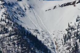
- It Finally Froze in Beehive Basin
Throughout our forecast area avalanches are unlikely and conditions are generally safe. Even with good stability, standard protocols apply: travel with a partner, only expose 1 person a time in avalanche terrain and carry rescue gear. Today the avalanche danger is rated LOW. If the weather forecast is wrong and the sun pokes out, slopes will get wet quickly and the danger will rise.
If you get out, please send us your observations no matter how brief. You can submit them via our website, email (mtavalanche@gmail.com), phone (406-587-6984), or Instagram (#gnfacobs).
This article in the Billings Gazette highlighting Dave’s January accident, shoulder injury and rescue is worth your time. Plan ahead and prepare for dealing with an injury in the backcountry and think about how you’d call for outside help.