Good morning. This is Doug Chabot with the Gallatin National Forest Avalanche Forecast on Thursday, April 7th at 6:45 a.m. This information is sponsored by Grizzly Outfitters and Spark R&D. This forecast does not apply to operating ski areas.
Under clear skies, mountain temperatures are in the mid-teens F with 15-25 mph wind from the northwest. High pressure is bringing brief and unseasonably warm weather. Under sunny skies mountain temperatures will reach 45-50 F this afternoon with wind 10-20 mph from the west to northwest. Temperatures will cool to near freezing tonight and rise quickly tomorrow. Enjoy the warm April sun because clouds, cooler temperatures and precipitation are on the menu for the weekend. Don’t fire up the lawn mower just yet.

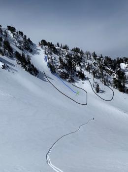
The snowfall from Monday night and Tuesday dropped 10-16” in the mountains around Cooke City, Hyalite and Big Sky. Wind during the storm loaded slopes even more. Because of the warm weather today, wet avalanches will make a comeback which means both wet and dry avalanches have to be considered. Avoiding dry avalanches requires digging and testing. Triggering avalanches at the interface between the old and new snow or on layers of weak snow 2-3 feet deep remains possible.
The wet snow avalanche danger will rise along with the sun. Slopes getting direct sunshine will soften, melt and trigger numerous point release, loose-snow avalanches by this afternoon, just as Ian warned in his latest video. Although wet avalanches are very different from dry slides, one can trigger another: a wet slide can trigger deeper, dry layers and avalanches that are dry in the starting zone can be wet further down the path. It is not uncommon to be unpleasantly surprised with unusual avalanches when temperatures rise above freezing for the first time in dry snow. Travel conservatively and avoid slopes that are getting wet. For today, the danger is rated MODERATE on all slopes, for both wet and dry avalanches.
The Bridger Range and mountains south of Big Sky to West Yellowstone received 4-6” of snow earlier in the week. Dry snow avalanches are unlikely today, but wet, loose snow avalanches will happen quickly in the thin, new snow. Intense sunshine will wet the new snow and the underlying ice crust will be a sliding surface once water starts to flow on it. Pinwheels and roller balls are signs the snow is getting wet enough to avalanche.
If you get out early and stick to dry powder the avalanche concern are wind drifts that formed Tuesday. Dave was in the Bridger Range that day and had some crack and break (video). Although the likelihood of triggering these drifts has decreased, it’s not impossible, so dig and test before committing to serious avalanche terrain. In general, the dry snow avalanche is rated LOW. The wet snow avalanche danger will increase through the morning and sunny slopes with moist snow will have a MODERATE danger.
Our last daily forecast will be issued on Sunday. During the rest of April we will issue weather and avalanche updates Monday and Friday. Please continue sending us your observations. You can submit them via our website, email (mtavalanche@gmail.com), phone (406-587-6984), or Instagram (#gnfacobs).
Our final daily avalanche forecast of the 2021-22 season will be April 10th. Thank you to everyone who has followed, submitted field observations and donated to the Friends of the Avalanche Center. We are grateful to be a part of your winter. We will continue to provide avalanche updates every Monday and Friday through April.