Good morning. This is Alex Marienthal with the Gallatin National Forest Avalanche Forecast on Monday, December 5th at 7:15 a.m. This information is sponsored by Highline Partners and Uphill Pursuits. This forecast does not apply to operating ski areas.
Please consider donating to the Friends of GNFAC Annual Fundraiser.
*Note: Bridger Bowl Ski Area is closed and there are no avalanche control or ski patrol services. Backcountry conditions exist. Please don’t ski over hoses and power cords, stay off chairlifts, and give snowcats and snowmobiles plenty of room.
Since yesterday afternoon the mountains received 6-10” of new snow in the Bridger Range, Cooke City and south of Big Sky to West Yellowstone. Hyalite and Big Sky received 5-8”. This morning, snowfall is tapering, temperatures are teens to 20s F and wind is southwest at 10-20 mph with gusts of 25-35 mph. Today temperatures will reach low to mid-20s F. This afternoon southwest wind will increase to 20-35 mph, and possibly stronger in the northern ranges. A few light snow showers are possible today with the next round of significant snow tomorrow morning near Cooke City, and throughout the forecast area later this week.

Today’s 6-10” of new snow equals 0.8-1.1” of snow water equivalent (SWE) and creates dangerous avalanche conditions. Southwest wind will increase through the day and drift the new snow into thicker, heavier slabs. The weight of new snow and drifts will stress weak layers deeper in the snowpack and could cause avalanches breaking 2-4 feet deep. Fresh drifts could break naturally, will easily avalanche under the weight of a person, and could trigger a deeper slide.
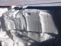
During and after the storm that dropped two feet of snow last Thursday and Friday there were large natural and human triggered avalanches near Cooke City (Sheep Mountain, Fox Mountain, Republic) and Lionhead (Airplane Bowl, Lionhead Ridge). Many of these avalanches likely broke on weak layers buried deeper in the snowpack. I was in Cooke City last week and found weak layers buried below the new snow (video from Friday, photo), and earlier last week Dave was in Lionhead and found weak layers that are now buried 3-4’ deep (video, photo). Over the weekend, skiers at Bacon Rind in the southern Madison Range saw recent natural avalanches, and had collapsing and unstable snowpack test scores on weak snow buried 1-2 feet deep (Bacon Rind observation).
New snow, wind and buried weak layers make large, human triggered avalanches likely and natural avalanches possible today. Avalanche danger is CONSIDERABLE. Cautious route finding and conservative terrain selection is essential.
Today’s 6-8” of new snow is equal to 0.8” of snow water equivalent and will be drifted by strong wind into fresh drifts that will be easy to trigger. Avalanches of new and wind-drifted snow will be large enough to bury or injure a person and could break deeper, on weak layers buried below last Thursday’s 6-8” of snow. Today’s new snow and increasing southwest wind create dangerous avalanche conditions and avalanche danger is CONSIDERABLE. Avoid steep, wind-loaded slopes and choose your terrain and objectives carefully.

Big Sky and Hyalite received 5-8” of snow equal to 0.4-0.6” of snow water equivalent. This snow will be drifted into thicker slabs by increasing southwest wind this afternoon. These slabs are possible for a person to trigger, and could break 1-2 feet deeper on buried weak layers. Today, Be cautious of fresh drifts on steep slopes and dig down to check for buried weak layers before riding any steep slopes. Human-triggered avalanches are possible and the avalanche danger is MODERATE.
If you get out, please share avalanche, snowpack or weather observations via our website, email (mtavalanche@gmail.com), phone (406-587-6984), or Instagram (#gnfacobs).
Upcoming Avalanche Education and Events
Our education calendar is full of awareness lectures and field courses. Check it out: Events and Education Calendar.
Monday, December 5, 6:30-7:30 p.m. @MAP Brewing in Bozeman, Know Before You Go avalanche awareness presentation.
Tuesday, December 6, 9 a.m. - 3:00 p.m. West Yellowstone Avalanche Fundamentals w/ Snowmobile Field Session. Pre-register HERE.
Thursday, December 8, 6 - 7:30 p.m., Free Snow & Avalanche Safety Workshop: Belgrade Community. This workshop will cover the basics of snow and avalanche equipment. Belgrade Community Library. A raffle and pizza will be included!
Monday, December 12, 5-8 p.m. @MAP Brewing, Movie Night.
Tuesday, December 13, 6 p.m., Avalanche Awareness + Beacons at Story Mill Park. Free.