Good morning. This is Ian Hoyer with the Gallatin National Forest Avalanche Forecast on Friday, January 27th at 7:00 a.m. Today’s forecast is sponsored by Mystery Ranch and World Boards. This forecast does not apply to operating ski areas.
AVALANCHE WARNING
The Gallatin National Forest Avalanche Center is issuing a Backcountry Avalanche Warning for the Bridger Range, Northern Madison Range and Northern Gallatin Range. Heavy snowfall and strong winds are creating very dangerous avalanche conditions. Natural and human triggered avalanches are likely. Avalanche terrain and avalanche runout zones should be avoided. The avalanche danger is rated HIGH on all slopes. Contact the Gallatin National Forest Avalanche Center for more detailed information.
This warning will expire or be updated by 6:00 a.m. on Saturday, January 28, 2023.
At 6 am there are 10-12” of new snow (0.8-1.3” Snow Water Equivalent) around Bozeman and Big Sky, and 5-6” (0.4-0.5” SWE) around West Yellowstone and Cooke City. Winds are 15 mph gusting 30 mph out of the southwest and west. Temperatures are in the high 20s in the north and teens in the south. It is currently snowing heavily in the northern mountains. Expect 12-18” more snow by tomorrow morning around Bozeman and Big Sky, much of that falling during the day today. West Yellowstone and Cooke City will get 6-12” today and tonight. Moderate southwest and west winds will continue.
Avalanche Warning
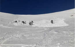
Heavy snowfall onto well developed weak layers has created very dangerous avalanche conditions. Both natural and human triggered avalanches are LIKELY today. Continued heavy snowfall today will keep pushing the snowpack further past its breaking point. There were already clear signs of instability before this heavy snowfall and conditions have deteriorated dramatically overnight (video yesterday on Buck Ridge). We’ve been telling you for the last month that conditions are going to get dangerous quickly when the weak layers get loaded - today is the day we’ve been warning you about. Avalanches can be triggered from below or break naturally above you as you’re crossing a runout zone. Avoid travel on or below slopes steeper than 30 degrees. The avalanche danger is HIGH.

Near West Yellowstone there is not quite enough new snow for an avalanche warning, but conditions are still quite dangerous. Large human triggered slides are likely. There are some extremely weak layers of surface hoar in the top couple feet of the snowpack. These layers avalanched earlier in the week during a wind event without any new snow (details and photos). New snow and wind have now pushed the weak layers right to their breaking point, your added weight will be all it takes to trigger a dangerous slide. Stay off and out from under steep slopes. The avalanche danger is CONSIDERABLE.
Wind loaded slopes around Cooke City are the most worrisome today. Weak layers aren’t as widespread or touchy as they are elsewhere, but there is weak snow and where it has a slab of wind drifted snow on top avalanches will be easily triggered today. These slides will break deeper and wider than if it were just a wind drift without a weak layer. Avoid steep wind loaded slopes and carefully assess the weak layers in the upper snowpack before riding any steep slope. If heavy snowfall develops today, all slopes will quickly become more dangerous.
The avalanche danger is CONSIDERABLE on wind loaded slopes, MODERATE on all others.
Please share avalanche, snowpack or weather observations via our website, email (mtavalanche@gmail.com), phone (406-587-6984), or Instagram (#gnfacobs).

In Island Park, large human triggered slides are likely. There are some extremely weak layers of surface hoar in the top couple feet of the snowpack. New snow and wind have now pushed the weak layers right to their breaking point, your added weight will be all it takes to trigger a dangerous slide. Stay off and out from under steep slopes.
KING AND QUEEN OF THE RIDGE, FEBRUARY 4TH
Do you like to hike? Do you like to ski? Then the King & Queen of the Ridge is for you. Hike, ski and raise money for the Friends of the Avalanche Center in their 2nd biggest fundraiser of the year. Join the effort to promote and support avalanche safety and awareness! Fundraising prizes for the top 5 individuals who raise over $500. No racing is necessary to compete for the fundraising prizes. Info is HERE. Race participants for the February 4th event must register separately with Bridger Bowl HERE.
Upcoming Avalanche Education and Events
Our education calendar is full of awareness lectures and field courses. Check it out: Events and Education Calendar.
February 4, 9 a.m.-3 p.m., LIVINGSTON Avalanche Fundamentals. Information and course registration are HERE.
February 5, 10 a.m.-2p.m. Companion Rescue Clinic Field Day in the Bozeman area. Required Online Classroom Session at 6 p.m. on Feb 3. Information and course registration are HERE.
February 9, FREE Avalanche Awareness at REI Bozeman. More details to come.
February 11, 10 a.m.-2p.m. Companion Rescue Clinic Field Day in the Bozeman area. Required Online Classroom Session at 6 p.m. on Feb 10. Information and course registration are HERE.
Every Saturday, 10 a.m. - 2:00 p.m. Avalanche Rescue Training, drop in for any amount of time. Round Lake Warming Hut, Cooke City. Free.
Loss in the Outdoors, is a support group for those who have been affected by grief and loss related to outdoor pursuits. Check out the link for more information.
Check out the weather and avalanche log for a rundown of recent weather and avalanche conditions.