Good morning. This is Dave Zinn with the Gallatin National Forest Avalanche Forecast on Tuesday, February 13th at 7:15 a.m. Today’s forecast is sponsored by Uphill Pursuits and World Boards. This forecast does not apply to operating ski areas.
AVALANCHE WARNING
The Gallatin National Forest Avalanche Center is issuing a Backcountry Avalanche Warning for the Bridger Range near Bozeman. New and wind-drifted snow are overloading an exceptionally weak snowpack, creating very dangerous avalanche conditions. Natural and human-triggered avalanches are likely. Avoid avalanche terrain and avalanche runout zones. The avalanche danger is HIGH on all slopes. Contact the Gallatin National Forest Avalanche Center for more detailed information.
This warning will expire or be updated by 6:00 a.m. on Wednesday, February 14th.
Mountain temperatures are in the single digits to teens F with 5-15 mph winds from the west to northwest. The Bridger Range and localized areas in the Northern Madison Range picked up 10” of snow in the last 24 hours, with 5-7” south of Bozeman and elsewhere around Big Sky and 2-4” near Cooke City, West Yellowstone and Island Park.
Today, temperatures will be in the 20s F with 5-15 mph winds from the west to southwest. Snowfall will taper off after an additional trace to 1” falls across the advisory area.
Avalanche Warning
Today is an avalanche accident waiting to happen. A powder-starved community and clearing skies will have excitement levels as elevated as the avalanche danger. Please do not get killed in an avalanche today.
Very dangerous avalanche conditions exist in the Bridger Range, where 10” of snow equal to 1.0” of snow water equivalent (SWE) fell in the last 24 hours. Natural and human-triggered avalanches breaking 1-2 feet deep are likely. Limit mountain travel to slopes less than 30 degrees and avoid avalanche runout zones.
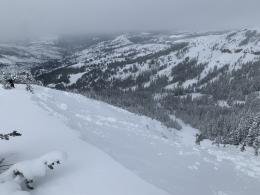
New and wind-drifted snow is not bonding well to the old snow surface. Yesterday at the Throne, we triggered small avalanches by tapping our ski poles on steep slopes. With more snow, these will be much larger. Additionally, we triggered an enormous collapse on a wind-loaded slope, causing us to tuck our tails and retreat (video). Similar slabs of wind-drifted snow avalanched naturally on Saddle Peak on Saturday afternoon (photo). The snowpack structure is very weak, and large avalanches breaking widely across slopes and running far into runout zones are on the table.
The danger is HIGH on all slopes.

Dangerous avalanche conditions exist in the mountains near Cooke City, West Yellowstone, Island Park, Big Sky and south of Bozeman. With new snow, we are again scratching the underbelly of an avalanche warning. Pioneer Mountain and Hyalite Canyon in the Northern Madison and Northern Gallatin Ranges came out on top with 7-10” of snow equal to 0.5-0.6” of SWE, while the rest of the area got 2-4” equal to 0.2” SWE.
Human-triggered avalanches breaking up to 4 feet deep and hundreds of feet wide are likely. Backcountry travelers have triggered slides from low-angle terrain above and below steep pitches with regularity this season due to persistent weak layers buried in the snowpack. This weekend, one group triggered three avalanches from low-angle terrain in Cooke City (photos and observation), a rider triggered a large slide on Lionhead Ridge from the safety of the flats (photo and observation), the same near Big Sky (photo and observation) and in Island Park (video). The largest was an avalanche that broke 4 feet deep and 4000 feet wide in Tepee Basin last Wednesday (photos, video and description). These are a small collection of nearly 50 entries of natural and human-triggered slides recorded in our avalanche activity log in the last week alone.
Conservative travel plans that stick to terrain less than 30 degrees are essential to coming home at the end of a fun day in the mountains. The danger is CONSIDERABLE.
If you venture out, please fill an observation form. It does not need to be technical. Did you see any avalanches? How much snow is on the ground? Was the wind moving snow? Simple observations are incredibly valuable. You can also contact us via email (mtavalanche@gmail.com), phone (406-587-6984), or Instagram (#gnfacobs).
King and Queen of The Ridge Results
We closed out King and Queen (of the Apron) with $23,208 raised! A huge Thank You to all who participated and raised funds for The Friends of the GNFAC! The community came out big after a postponed event; participants were crushing boot pack laps and even getting some powder turns while fundraising for Friends of GNFAC. Top Fundraising teams were: Cooke City Exxon ($8,271), Science Saves Lives ($4,292), and Map Brewing Company ($1,905). Top individuals were: Mathew S., Dash R., Ron J., Katie B, and Tobin I.
Thank you to the Bridger Bowl Events team for all their work, Weston Boards, Bozeman Hot Springs and Blue Ice for donating prizes!
Upcoming Avalanche Education and Events
Our education calendar is full of awareness lectures and field courses. Check it out: Events and Education Calendar.
Every weekend in Cooke City: Friday at The Antlers at 7 p.m., Free Avalanche Awareness and Current Conditions talk, and Saturday from 10 a.m.-2 p.m. at Round Lake Warming Hut, Free Rescue Practice.
Loss in the Outdoors is a support group for those affected by loss and grief related to outdoor pursuits. Check out the link for more information.
A skier and a snowmobiler lost their lives in avalanche accidents in Colorado and Wyoming this week. Read accident reports to learn from these tragedies.
In Alex’s recent article for the Montana Snowmobile Association, he revisits our concerns about the abnormally weak snowpack in Southwest Montana. In the last week, there were nearly 50 entries in our Avalanche Activity Log. Do not mess with this snowpack!