Snow Observations List
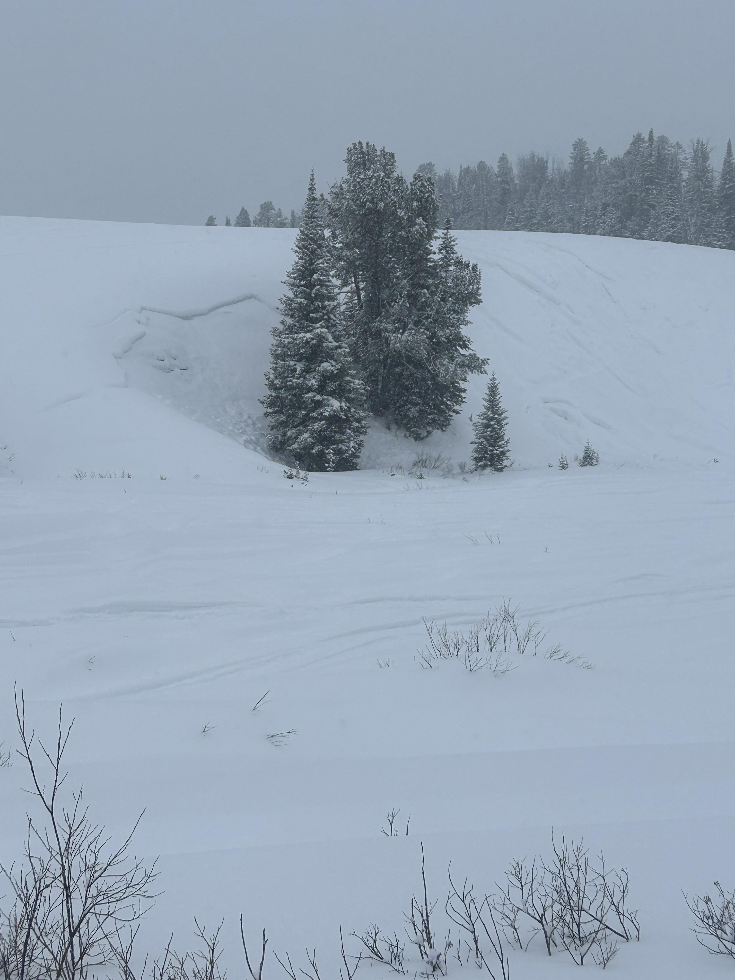
We skied into Beehive Basin. It was snowing lightly with calm wind. Skinning to Tyler's slope we could see wet avalanche debris from last week. We dug on the flank of Tyler's slope to look at the crust, but the snowpack was very thin and not representative of starting zones. The corniced ridge only had minimal new snow loading. As we skied up we had no collapsing. We dug in the trees on an east facing slope near the ridge, not far from all the holes the recent avalanche students made. We found 100cm of snow and got an ECTP15 on facets at the slab interface. A 5cm melt freeze crust is a nice marker from last week and Ian measured 1" of SWE above it, effectively doubling the slab depth/weight. We were in the fog on the ridge and could not get a look around.
Full Snow Observation ReportThe area is pretty hammered with tracks and snowpit holes. Digging near Tyler's does not seem to be representaive of anything important, so I'll probably blow that off in the future.

We rode to the the Fairy/Frazier Basin divide today to check out snow conditions and see what people had gotten up to over the weekend. The new snow had settled to about 4" or so and we did not notice any wind affect at lower elevations on the road but did find some deeper drifts hiding in the lee pockets in the meadows higher up. The climb up to the divide with Frazier only had 2-3 inches of fresh snow on it, and the saddle was nearly bare. Under the new snow there is a in places stout crust from the warmup last week (and past wind) which made for unpredictable riding. There were slick spots, breakable spots, and some fresh drifts. The ridge lines all were scoured as expected from the recent wind but we did not see any significant recent avalanche activity in the new snow, only a couple very small pockets had slid near the ridge tops and these were few and far between.
Full Snow Observation Report
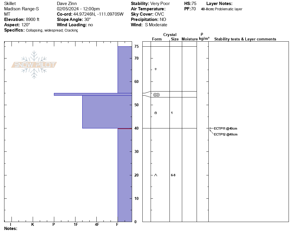
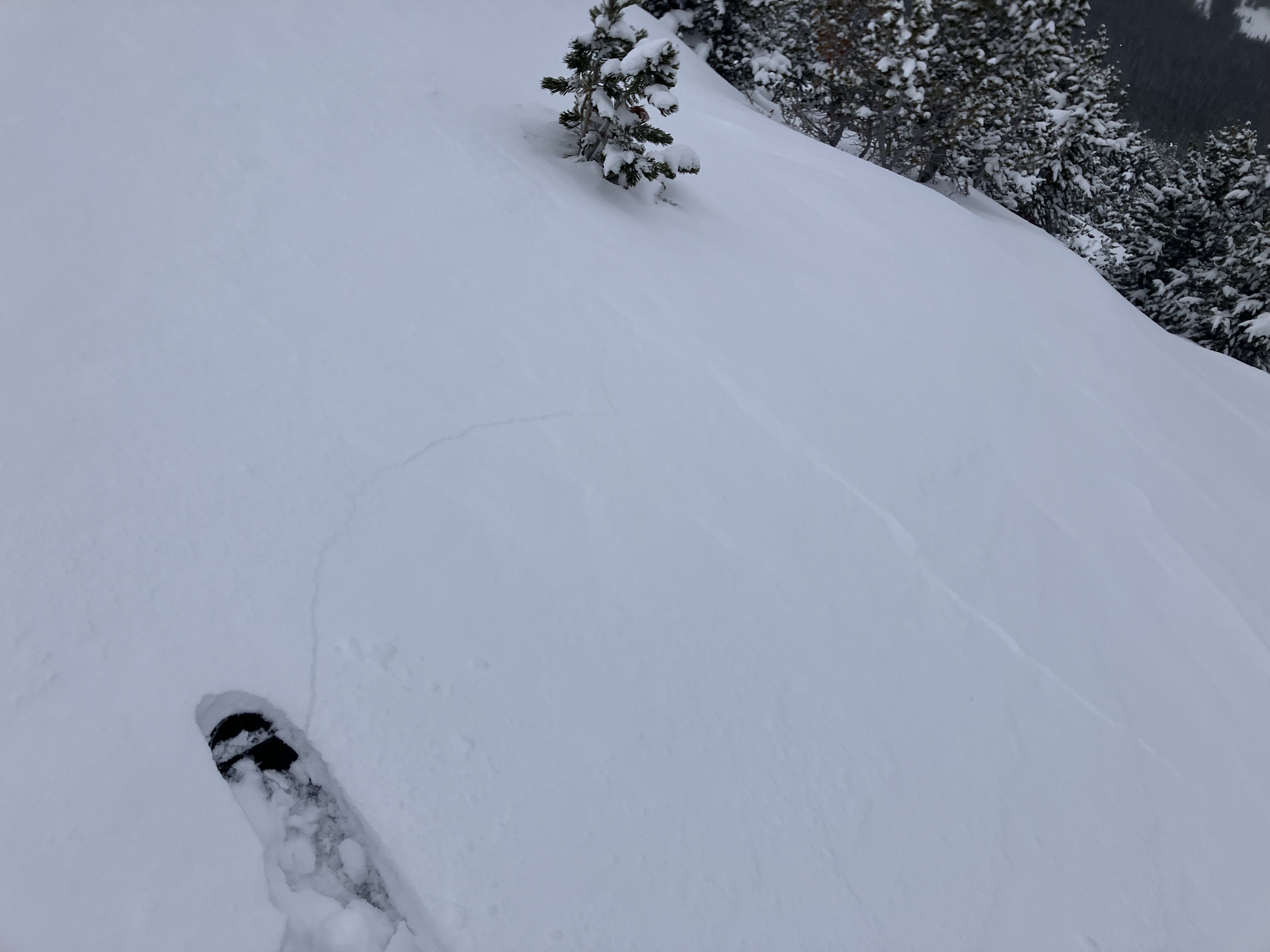
The stability at Bacon Rind was very poor, avalanches were likely, and we avoided (and strongly recommend avoiding) avalanche terrain. We triggered booming collapses and watched cracks shoot out across terrain features and snow shake off nearby trees for the entirety of our tour from the meadow near the car to the top of the Skillet. We avoided steeper meadows and gave the "Skillet" (the primary avalanche path where we were) a wide berth because we felt triggering a slide was so likely.
There was 8" of new snow. The upper half of the snowpack was a slab, and the lower half was airy depth hoar stressed to the point of failure. Snowpit results were ECTP11 and 12 failing 35cm down from the surface. As we have noted previously, do not trifle with this season's snowpack. It is exceptionally weak and will be slow to stabilize based on all evidence thus far this season.
Full Snow Observation ReportThe avalanche warning was well justified. The danger was HIGH at all elevations.
Also, Doug got us lost as we skied out, and we were simply trying to follow our skin track back to the car. We ended up traversing north from mid-elevation, crossed the skillet run out, and popped out by Gallatin River a ways from the car. In his defense, Dave could have said something but assumed that he was wrong based on Doug's expertise and happily followed along for the traverse-a-bout. Expert-Halo bias verified. Who let these guys out of the office!
DC: First "girdle traverse" of Bacon Rind!

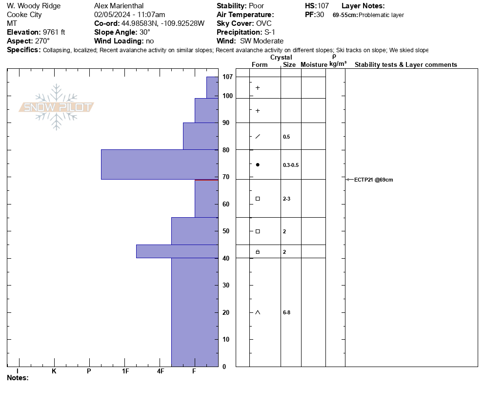
We skied south of Cooke City and dug a snowpit at 9,761' on a west facing slope. We had an ECTP21, 40 cm below the surface (16" down). There was 6-8" of new snow from the weekend above 4" of soft old snow, on top of 4" of a pencil- hard slab, then the soft sugary facets to the ground. ECT broke below the hard slab at the top of the facets (photo). I had one collapse, 10-12' wide near treeline where there was little more wind-loading/effect (photo).
The unstable test score, very poor snowpack structure, and collapse indicate a person could easily trigger a large avalanche on steep slopes.
Snowed lightly on and off all day with a couple cm accumulation. Wind was light-moderate out of the southwest with mostly overcast skies.
Full Snow Observation Report

I did some digging around on the Ramp this morning. Got propagating test scores with moderate force in 3 snowpits. Pit from just below the ridgeline on an East aspect at 8500' had a snow height of 120cm: ECTP16 down 60cm, interface between 4f facets and larger fist facets. A thin, soft 1cm MF crust was present down 15cm. I dug at 8000' on a South aspect, height of snow was 60cm, ECTP11 down 30cm below a 20cm MF crust, wet depth hoar to the ground. I also dug on a SE aspect at 8200', height of snow was 65cm ECTP13 down 40cm on dry depth hoar below a 15cm MF crust.
Except the top 200', a stout MF crust was near widespread below the new snow. Tracks in steeper terrain showed small loose dry slides contained to the new snow. It was warm, southerly aspects were getting wet by mid day, wind was light, I didn't observe any evidence of transport.
Thanks for all your hard work!
Spencer
Full Snow Observation ReportToured up near fairy lake today. Several natural avalanches on Pomp, Sac, and Naya Nuki. Numerous whumphs traveling through the meadows. Did a quick pit on an eastern aspect at 8000'. HS110cm. ECTN8 at the melt freeze crust 95cm and ECTP21 at 65cm on some 1-2mm facets. By about 10:30AM winds were picking up and we boogied out of there.
Full Snow Observation ReportFrom FB:
No avalanches observed. A foot of new snow in 24hrs, 3-4 inches throughout the day. Strong wind gusts in the morning into early afternoon, drifting in open areas and higher elevations. Experienced multiple whoomphing in an open flat area.
Full Snow Observation ReportGabe Gassman and I rode buck ridge to the wilderness boundary at Macatee basin on a LE patrol mission. 6-8 inches of new snow fell since yesterday. Snow depth was variable as it had been affected by wind, but wind during the day was calm to 10mph. No avalanching of the new snow was observed.
Full Snow Observation ReportSkied conservatively terrain below 30 degrees today. Widespread whomping. Along the steeper part of the uptrack, we experienced settling and shooting cracks.
We agreed that in steeper terrain this would have led to an avalanche.
Full Snow Observation Report
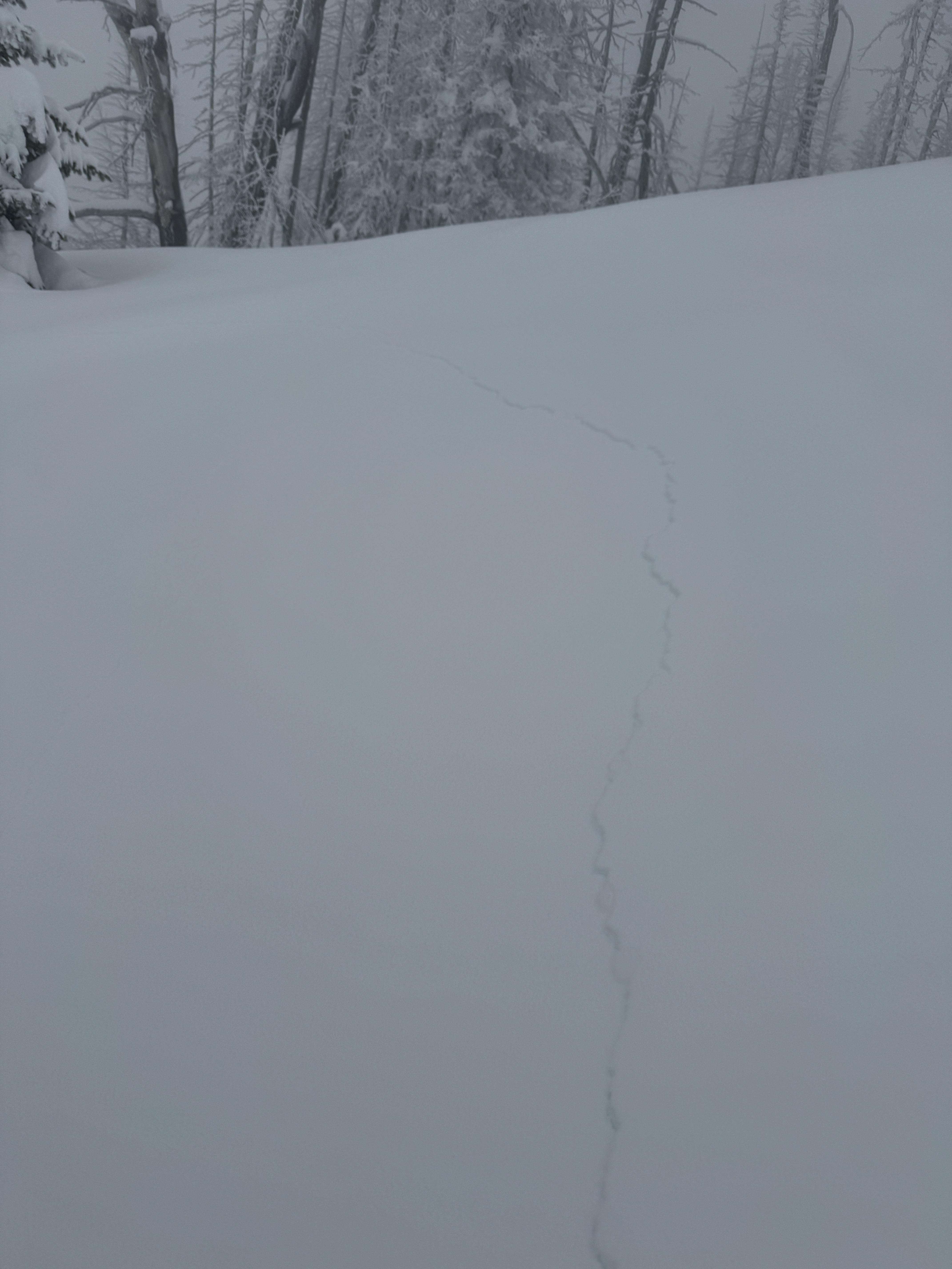
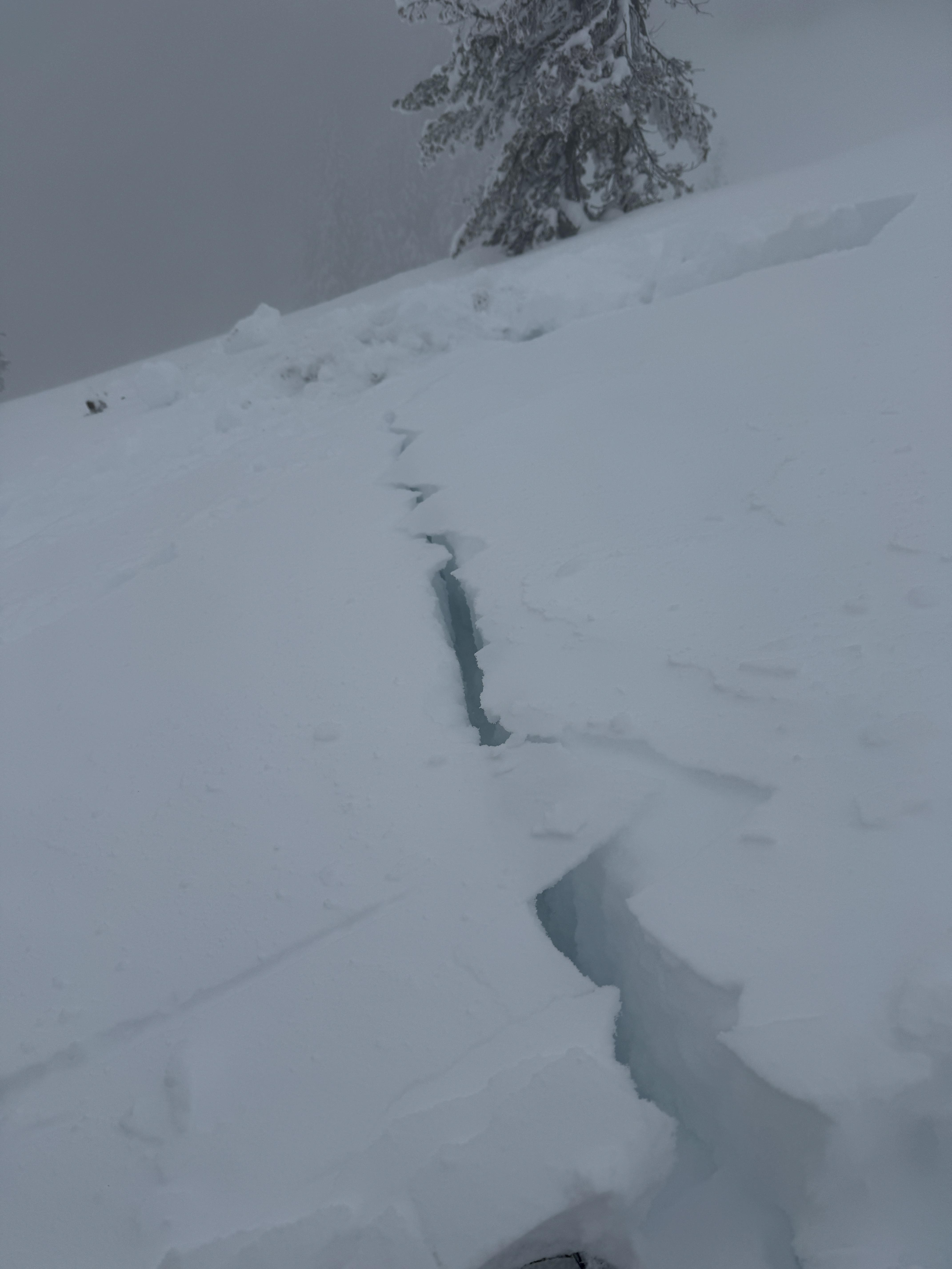
Four of us (all with 20-40 years backcountry experience) skied the lower angle slopes just south of the skillet at Bacon Rind. There was a well worn skin track from past weeks and lots of old down-tracks buried beneath ~8-10" of new snow. We heard numerous large-scale collapses and witnessed the development of propagating tensile fractures on a 20°-25° slope along the skin track (see photo/video). No need to dig a pit on days like this. We did not venture onto or view any steeper terrain, so we saw no natural avalanches. The new snow seems well-adhered to the older snowpack. All instability is tied to the lowest 20-30cm faceted sequence at the bottom.
We skied this location 4 times this week. Each time, we experienced collapsing and fracturing within the snowpack and stuck to skiing conservative, low-angle lines. The takeaway? Previous skier traffic may not indicate safety or diminish avalanche danger. If conditions are even somewhat questionable, stick to low-angle slopes or go nordic skiing (on groomed trails).
Full Snow Observation Report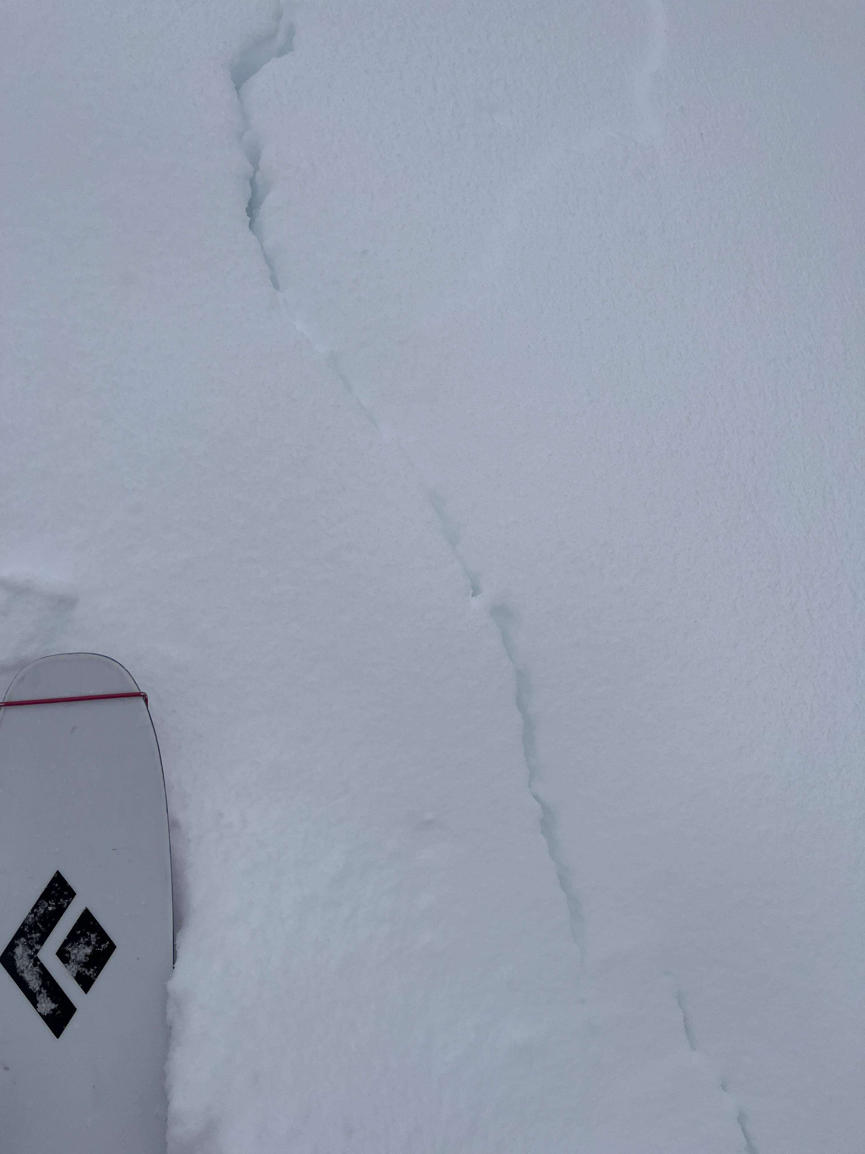
Observed a fresh avalanche this afternoon on Woody Ridge, South of the Submarine. Northwest facing slope, Approximately 10,150'. Appeared to be from today, 2/4.
Full Snow Observation Report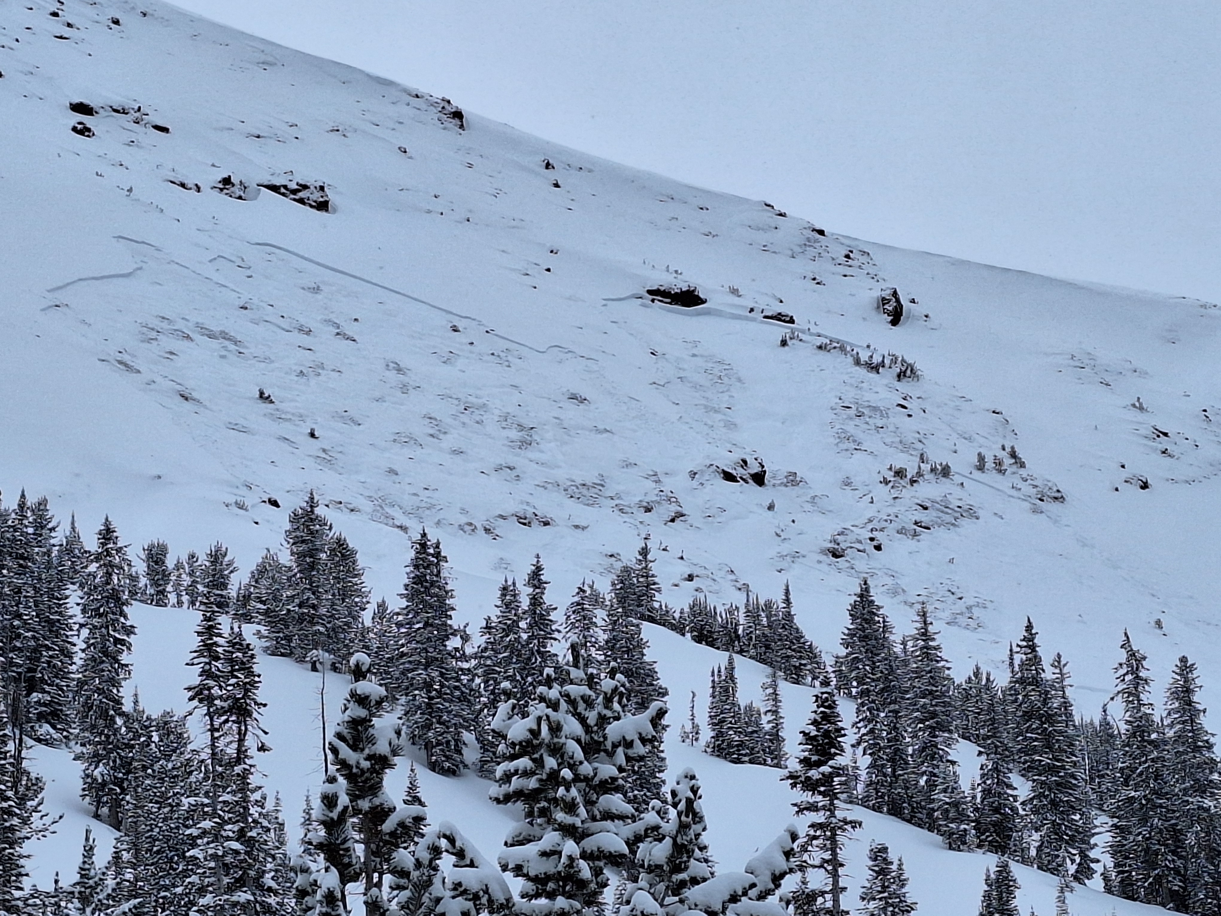
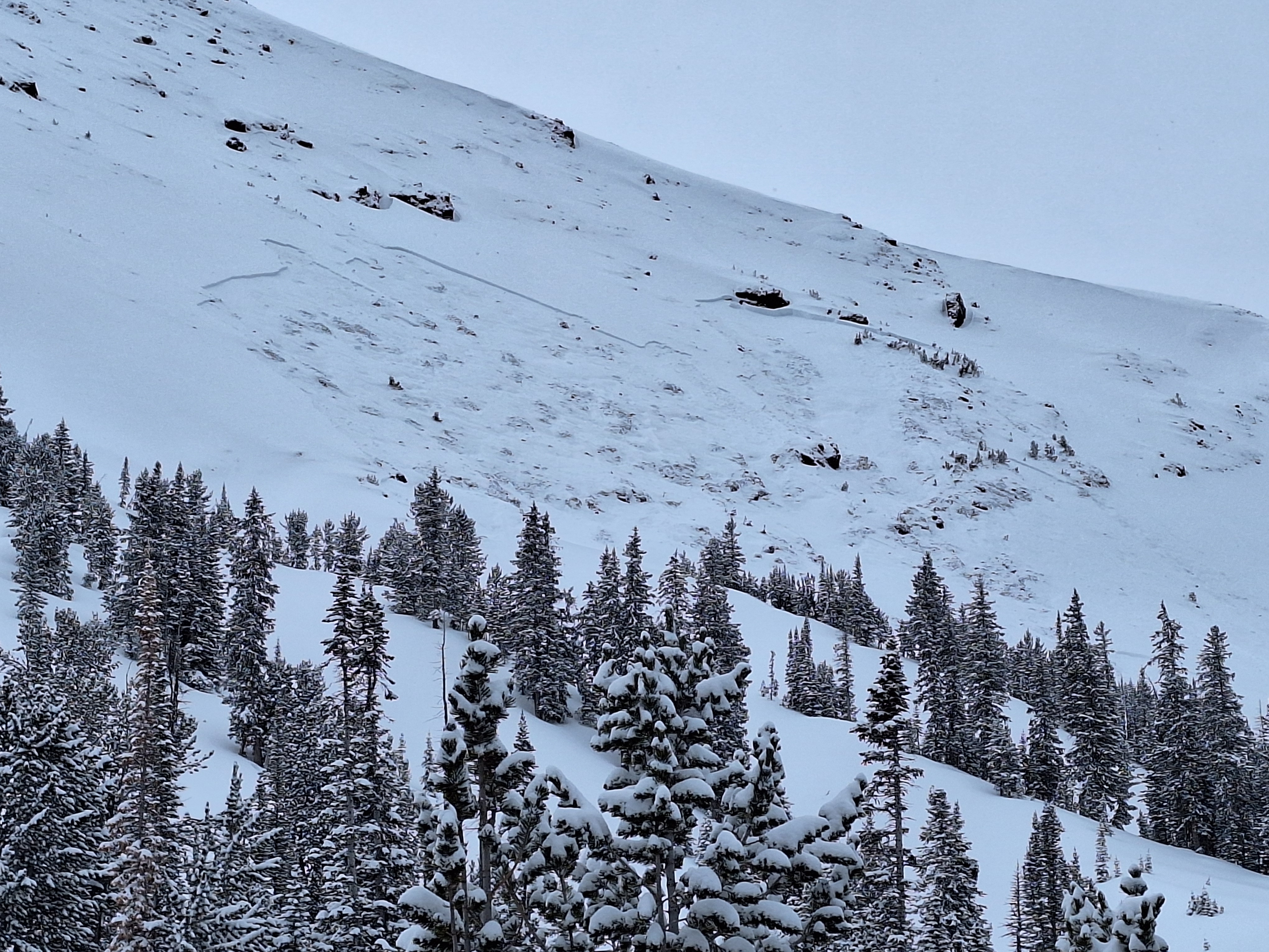
Multiple natural avalanches and at least one suspected human triggered dry loose in Beehive Basin. Most naturals appeared to have run either last night or yesterday (2/3/24), with a couple potentially older slides. New snow and rapidly changing cloud cover/depth perception made it a bit hard to be sure. Suspect one skier trigged dry loose in W facing trees. One of the W-facing chutes further up valley was also observed to have a crown line at approximately 9000' (no photo)
Full Snow Observation Report
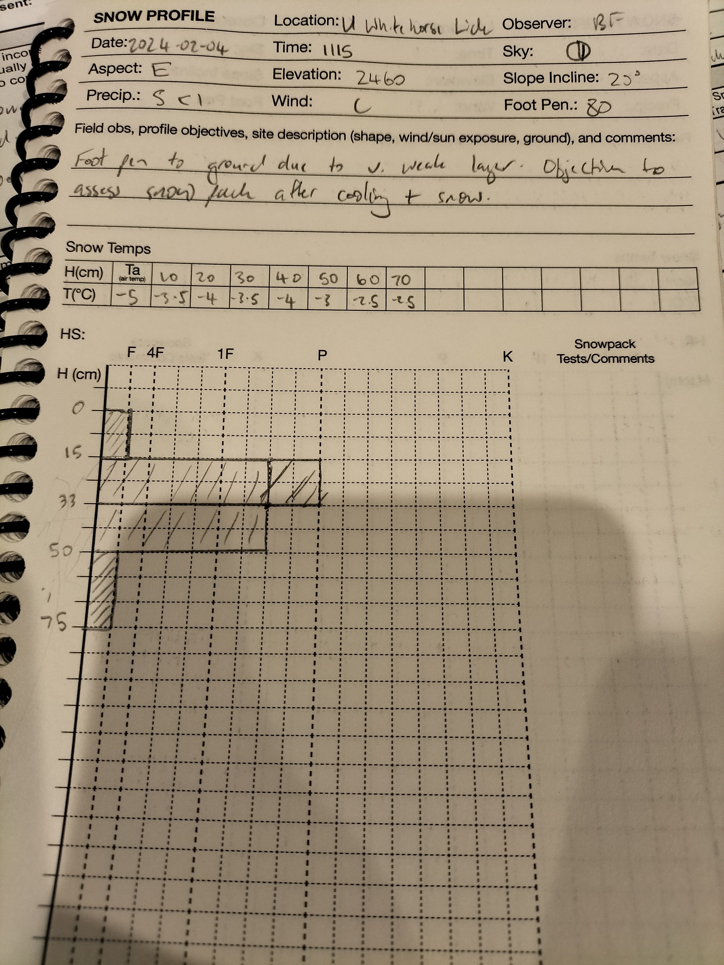
Main points of test profile to ground at N45°31.5026' W110°57.3867'
- Foot pen all the way to ground with very weak layer at base.
- Some rounding at the mid snowpack (15cm down to 50cm) with ~P resistance.
- MFcr interface layer @ 20cms
- CT Result
- CTM 14(SP) down 50cm
- ECT Result
- ECTN7 down 15cm
- ECTP27 down 50cm
On the terrain travelled, NE - SE slopes have ~70-80cm coverage. W slopes have very thin cover and presented minimal avalanche risk.
Full Snow Observation Report
We rode north of Cooke City today, 02/04/2024. We stopped below Fisher Bench and dug on an NE-facing slope at 9600'. What we found were unstable test scores, ECTP25, and a poor structure of weak snow. This pit had a well-defined strip of surface hoar that stability tests were failing on.
We moved on from here over Lulu Pass and towards the wilderness boundary. Along the way, we saw multiple old avalanches and a few more recent ones from last week's warm-up. While climbing a small test slope I saw shooting cracks coming from my skis, and could feel my track breaking through the slab to the weak snow below. Overall the snowpack is in poor shape and just putting a foot down in some places it was easy to break through the slab and fall to your waist in facets.
Light snow fell through the day will little daytime accumulation. The storm was well distributed with 3-4" in all the areas we rode today. Winds were calm and the sun tried to break through the clouds but it remained mostly cloudy.
Full Snow Observation Report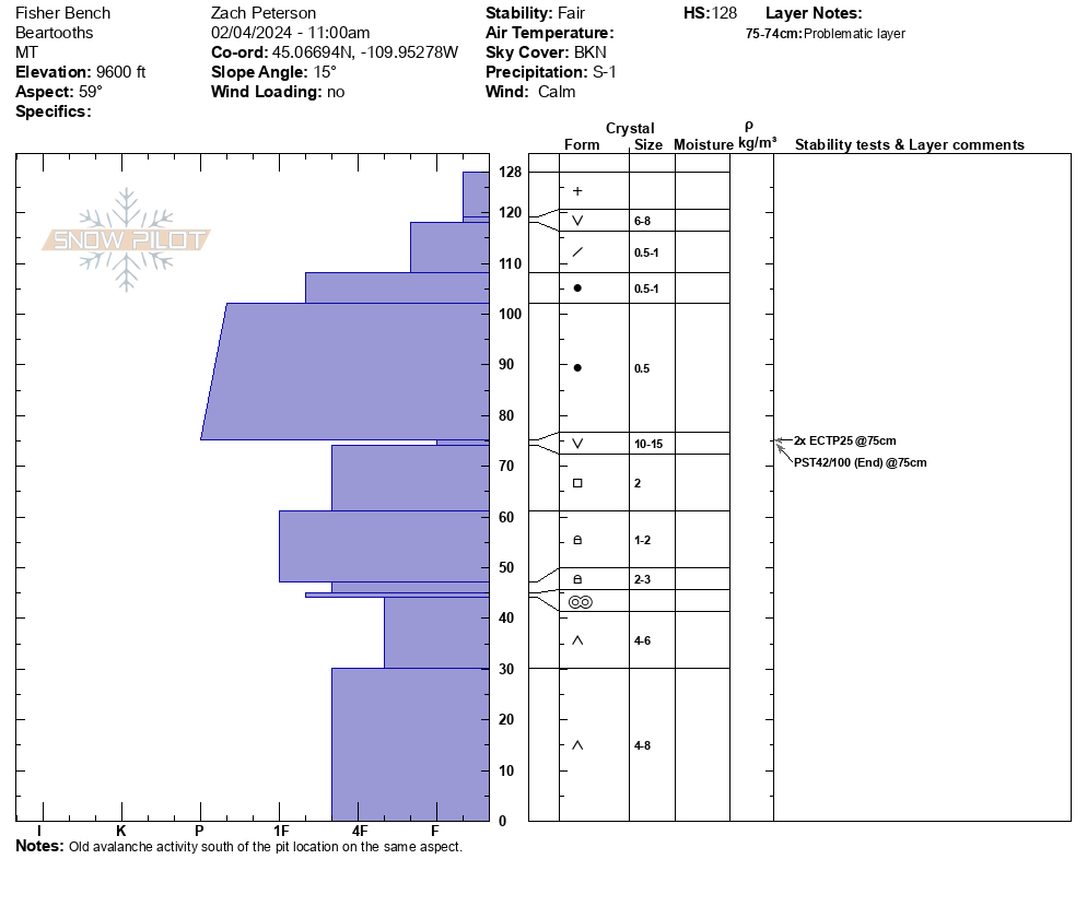

We dug a pit near the top of the skin track, and when approaching the location we experienced a big wumph. After digging our pit, we got a ECT3 on the more recently buried weak layer.
Full Snow Observation Report
Went snowmobiling/skiing below White Peak. We saw older crowns down low in the meadows. While skinning up a mellow south facing nose off white peak, we dug down and got a ECTP15 2.5 feet below the surface. About 8-10 inches of snow fell throughout the day up high. As we continued to skin up higher, we observed numerous collapses before we decided to call it a day. We observed that aspects without a crust layer from this week were more reactive, although we saw propagation on solar aspects with a defined crust as well.
Full Snow Observation Report
From email: "Temp 27. 4'' new snow, Rate S1, Sky OVC. NE aspect, SE winds, L observed localized drifting. Elevation 7790’. conducted several CT tests scored CTM and CTH (SC) ECTP 21, NE of Two Top on a layer of SH 35cm from surface. New snow on a melt freeze crust very reactive CTE 15cm from surface. Possible new layer of concern as new snow accumulates. No recent avalanches observed."
Full Snow Observation Report120 cm HS, OVC, E aspect, 6" new snow, -4c air temp, 14 deg. incline, blowing snow: none. ECTP 22 at 101 cm
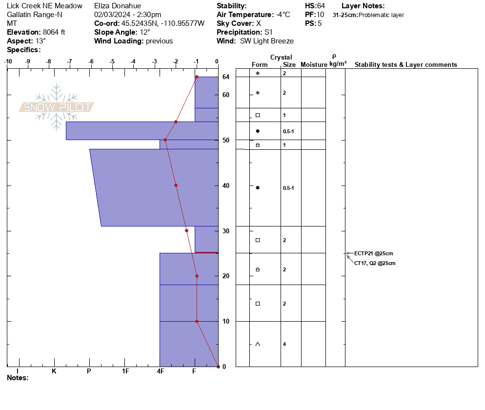
Full Snow Observation ReportWent up Lick Creek today with the intention of getting out in the new snow and doing some digging. We dug a couple pits on a north aspect at the top of the meadow at 8064' in an area of wind drifted snow. We observed propagation in both pits up 25cm on a faceted layer. HS 64cm, ECTP21, CT17 Q2. Skiing on the SE aspect was very thin but decent on a firm supportable crust formed during last week's warmer temps.
Full Snow Observation Report