All Avalanche Incidents for Advisory Year 2019-20
SS-N-R1-D1.5-I
Coordinates: 45.4472, -110.9620
Caught: 0 ; Buried: 0
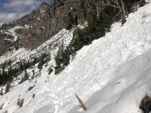
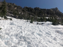
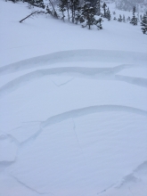
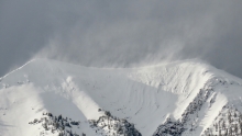
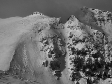
A skier in Hyalite wrote, "Natural activity that I observed was failing at new/old interface and (generally) occurred in predictable, wind loaded locations near ridge lines. The one exception is the avalanche with the freshest debris; looks like it failed right at the end of the storm in a somewhat sheltered, mid-slope location." Photo: B. VandenBos
More Avalanche Details
SS-AS-R1-D1
Coordinates: 45.8156, -110.9230
Caught: 0 ; Buried: 0
Several reports of small skier triggered slides at Bridger Bowl (10/29).
From instagram:
"I kicked off a small 6 inch slab on a rollover skiing down east of PK."
"Skied ptarmigan this morning, kicked off a decent sized slab rolling over deer park road cross from avy gulch."
"I got a 2 foot wind slab to crack on a test slope. There was lots of evidence of heavy wind affect. Saw a 5 inch by 20 foot slide in sluice box gully (skier triggered)."
From an email: "Skinned part way up Slushmans yesterday, saw that a chunk of cornice had fallen over the south side of the football field and took a medium-sized slab with it. The debris didn’t make it over the cliffs, but I did see debris further to the south."
More Avalanche Details
SS-N-R1-D1.5-S
Elevation: 8,000
Coordinates: 45.8156, -110.9230
Caught: 0 ; Buried: 0
Gusty North wind and moderate snowfall created sensitive drifts. From obs. "Some moved while I was skinning up, some slid naturally (hidden/[Apron area]) mostly recent wind deposition.
More Avalanche Details
SS-AS-R1-D1
Coordinates: 45.8156, -110.9230
Caught: 0 ; Buried: 0
Small storm slabs triggered at Bridger Bowl on 10/26. From email: "slab formation appeared isolated to leeward sides of midslope terrain features and rollovers as well as at ridgetops".
More Avalanche Details
SS-AS-R1-D1
Aspect: E
Coordinates: 45.4444, -111.0040
Caught: 0 ; Buried: 0
A skier reported lots of wind transport and triggering several thin wind slabs on the east face of Mt. Blackmore, in the northern Gallatin Range (10/25).
More Avalanche Details
HS-R2-D2-O
Elevation: 10,000
Coordinates: 45.0607, -111.2720
Caught: 0 ; Buried: 0
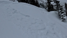
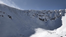
From email: "Found this large slide just north or Imp today [10/25]. Right around 10k, N-NE aspect, crowns spanned estimated 800-1,000' and ranged from ~2-10' thick. Appeared to activate by both a weak layer near the ground and a mid-pack interface. Lower interface was pencil hard, variably icy melt freeze crust of some sort, with 10-20 cms of 2-3mm facets underneath. Didn't get a good handle on the mid-pack interface, mostly assumed its presence based on shallower crowns.
Also saw several other crowns, at similar and slightly lower elevations on similar aspects to the SW of above described slide. Other crowns appeared thinner and less wide."
More Avalanche Details
L-NC-R1-D2
Elevation: 9,100
Coordinates: 45.7943, -110.9360
Caught: 0 ; Buried: 0
Skiers noted recent activity on Saddle isolated to fresh cornice fall and loose snow sluffing. The snow still available for transport was isolated to upper elevations, as mid/lower elevations the snowpack was wet and warm.
More Avalanche Details
SS-AFu-R1-D1
Coordinates: 45.4327, -110.9750
Caught: 0 ; Buried: 0
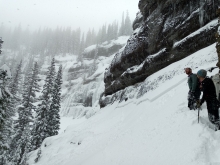
Ice climbers triggered a small avalanche while approaching the Twin Falls ice climb in Hyalite Canyon on Sunday (10/20).
More Avalanche Details
HS-N-R2-D1.5-O
Elevation: 9,650
Aspect: NE
Coordinates: 45.3810, -110.9610
Caught: 0 ; Buried: 0
More Avalanche Details
AF-O
Elevation: 9,000
Aspect: N
Coordinates: 45.1582, -111.4770
Caught: 0 ; Buried: 0
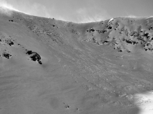
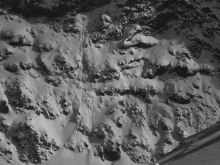
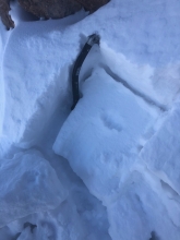
From e-mail on Saturday 10/5, climbers on the Sphinx found these conditions: "We found a lot of snow on the Sphinx today following heavy precip since Sam’s report two days ago [see photo]. 3-5 cm in the parking lot, 20 cm at the Sphinx-Helmet col. Moderate SW winds had created drifts almost a meter deep in places on the traverse to the ice routes on the north face. I backed off after a whumph on a particularly exposed section of the traverse. We tried different ledge systems above and below the normal approach route but found similar snow conditions throughout."
Photo: From 10/3 prior to 8-10" new snow, "No snow hazard of much concern on the approach. However, a quick hasty pit in an isolated wind pocket revealed a CT1 on this layer. ice axe is to the ground."
More Avalanche Details
SS-AS-R1-D1-S
Elevation: 9,000
Coordinates: 45.9043, -110.9580
Caught: 0 ; Buried: 0
From e-mail: "The only places one could ski were wind pockets blown into the limestone fin features that in places were well over a foot. These spots were also where the snow was weirdest/posed any sort of avalanche hazard as you pretty much had to find a wind slab in order to ski anything! One group reported triggering a slab in one of these spots, but vis was too poor to see."
More Avalanche Details
WL-N-R2-D1.5
Elevation: 9,000
Aspect: SW
Coordinates: 45.4900, -110.4950
Caught: 0 ; Buried: 0
From e-mail: "A couple wet slides buried the trail up to 4’deep on a sw facing slope approaching 9000’ in elevation. Probably set off yesterday with clearing skies. Snow depth was about 14” at Jewel Lake."
More Avalanche Details