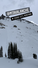
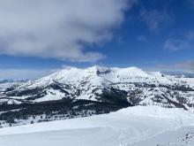
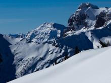
All Avalanche Incidents for Advisory Year 2021-22
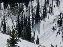
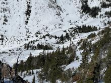
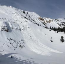
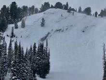
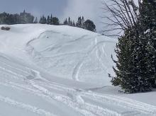
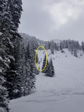
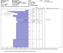
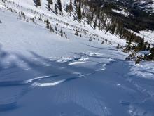
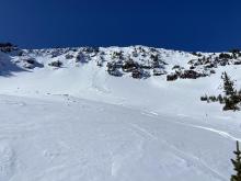
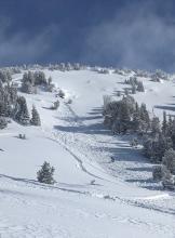
SS-N-R2-D1.5-S
Elevation: 7,500
Coordinates: 45.8156, -110.9230
Caught: 0 ; Buried: 0
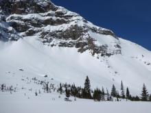
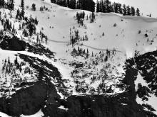
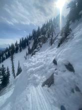
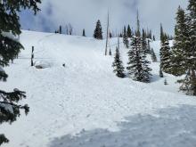
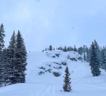
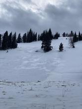
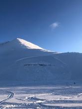
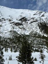
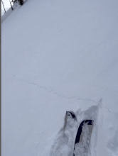
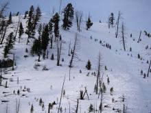
There were many similar depth, 8-12" natural crowns along the ridge that broke this morning or overnight within the recent snow that fell over the weekend.
More Avalanche Details
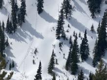
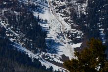
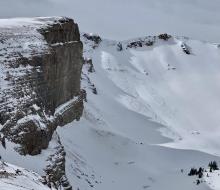
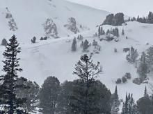
WS-N-R2-D2-O
Elevation: 9,800
Aspect: NW
Coordinates: 45.0525, -109.9620
Caught: 0 ; Buried: 0
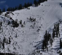
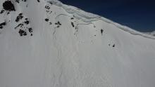
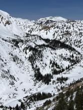
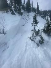
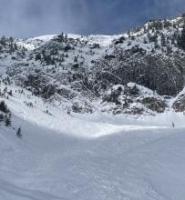
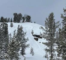
Natural slab avalanche on Crown Butte. Appears to be a wet slab that likely occurred 5/3 or 5/4/22. This same slope slid after a heavy snow storm a couple weeks ago on 4/23. Photo: @markass406
More Avalanche Details
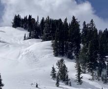
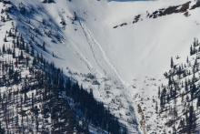
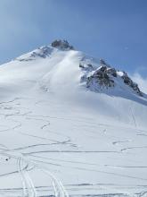
WS-N-R2-D2-O
Elevation: 9,000
Aspect: N
Coordinates: 45.0202, -109.9380
Caught: 0 ; Buried: 0
More Avalanche Details
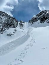
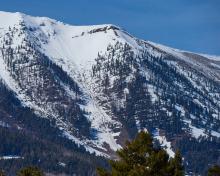
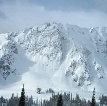
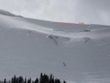
WL-N-R1-D1.5-I
Elevation: 8,500
Coordinates: 45.3407, -111.3910
Caught: 0 ; Buried: 0
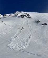
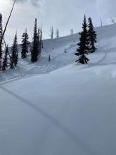
Widespread natural loose snow avalanches on 5/4 in Bridger and Beehive. 6-12" of snow that fell on 5/3 was quickly reactive when the sun came out with temps to 40 F on 5/4.
More Avalanche Details
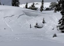
L-AS-R2-D1.5-I
Elevation: 9,000
Aspect: W
Coordinates: 45.3225, -111.3820
Caught: 0 ; Buried: 0
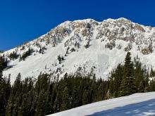
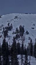
5/3/22 at approximately 4:00pm a storm slab avalanche occurred in beehive basin on a west aspect @9000 ft. This slab was 6-8” deep and propagated around 50’. No one was buried, however we aren’t sure if anyone was caught because we were not the party who triggered this avalanche. We did witness the party drop in but quick went out of sight.
More Avalanche Details
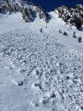
WL-N-R2-D2-I
Elevation: 8,000
Aspect: E
Coordinates: 45.8156, -110.9230
Caught: 0 ; Buried: 0
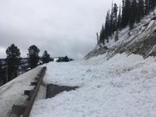
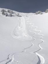
From 4/30/22: "...there were several wet loose avalanches at Bridger today. Some with ~5cm of snow on top, maybe from yesterday or earlier in the week, and some new this morning. We watched a relatively slow moving natural size 2 come down Colter's area around 10:30. We also ski cut a size 1.5 from the skiers right of the Lower Nose (NE asp) around 9:45 which ran on the melt freeze crust from earlier this week. It moved slowly but I was surprised by how much mass it entrained. A couple other ski cuts just above had produced smaller size 1s. The debris stopped on top of an older debris pile which was significantly larger and had run significantly further. (You can kind of see the difference in the photo). There was also widespread roller balling and pinwheeling on all aspects and elevations. Note - sizes are D sizes..."
More Avalanche Details
SS-AS-R1-D1.5-I
Elevation: 8,900
Aspect: E
Coordinates: 45.3453, -111.3750
Caught: 0 ; Buried: 0
A meadow descending into bear basin. Sun affected, new snow sliding.
More Avalanche Details
SS-N-R2-D2-I
Elevation: 9,800
Aspect: NW
Coordinates: 45.0497, -109.9640
Caught: 0 ; Buried: 0
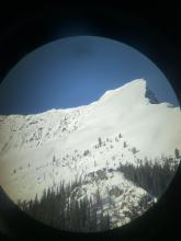
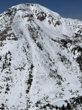
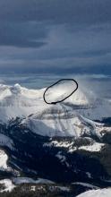
Riders observed a large natural avalanche near Daisy Pass.
More Avalanche Details
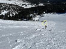
SS-N
Coordinates: 45.8156, -110.9230
Caught: 0 ; Buried: 0
A skier sent a video showing many new snow avalanches around the Schlasman's Lift.
More Avalanche Details
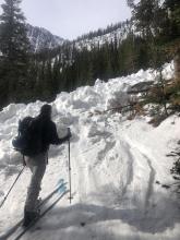
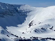
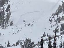
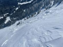
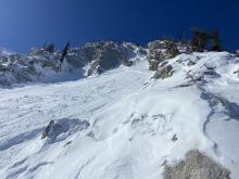
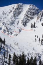
SS-ASc-R3-D3-I
Elevation: 8,000
Aspect: E
Coordinates: 45.8156, -110.9230
Caught: 0 ; Buried: 0
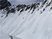
A pair of skiers ski cut the main chute of Avalanche Gulch. It propagated widely and ran approximately 800' vertical.
More Avalanche Details
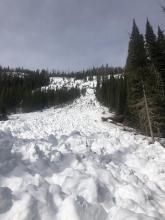
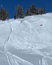
SS-ASu-R3-D2-I
Elevation: 8,275
Aspect: NE
Coordinates: 45.8156, -110.9230
Caught: 0 ; Buried: 0
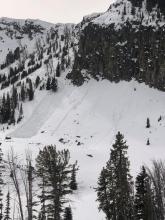
A group skied Manman's and triggered the upper chute. When the initial avalanche hit the fan the slide propagated wider and ran "Well past the North Bowl Road"
More Avalanche Details
Coordinates: 45.8156, -110.9230
Caught: 0 ; Buried: 0
Skiers reported shooting cracks from their skis while ascending the terrain at Bridger Bowl. The group later remotely triggered an avalanche from 100'+ away.
More Avalanche Details
SS-ASu-R2-D1.5-I
Elevation: 8,300
Aspect: E
Coordinates: 45.8156, -110.9230
Caught: 0 ; Buried: 0
A group of skiers was ascending above the top of the Bridger Lift. They had noticed many signs of instability such as shooting cracks and the new snow "rippling downhill". They choose to ski down before getting into the steeper terrain above them. A couple of turns into the run they noticed the steep slope above avalanche. They were not caught or affected by this slide. The slide ran in both the "Patrol Chute" and "Pearly Gates" areas.
More Avalanche Details
SS-N-R2-D2
Coordinates: 45.9043, -110.9580
Caught: 0 ; Buried: 0
From email: "Saw debris from a fairly recent slab avi that slid in lookers right of arrowhead bowl (tough to see in photo but the crowns appeared to be a couple feet deep). There were a bunch of other debris piles on similar aspects but I was too far for photos. They probably slid on Friday night [4/22/22] as the debris had a few inches on top. "
More Avalanche Details
SS-AF-R2-D2
Coordinates: 45.3407, -111.3910
Caught: 2 ; Buried: 0
Skiers caught and carried in 4th of July Couloir, in Beehive Basin on Friday, April 22nd.
From email: "just under the top of the couloir, my partner noted that the new snow
had become much denser, an observation I did not register. Immediately after making this observation,
he watched a crack propagate from his ice axe, upslope and to the left about twenty feet. In response,
he shouted and attempted to self-arrest, but was unable to resist the moving snow and was pushed
over backwards. I was immediately behind him as this happened and noted the moving snow around me
as he called out. I’m not entirely sure how, but I managed to move sideways, out of the moving snow,
before I had been carried through the constriction in the couloir. As I stood up, I watched as my partner
was carried out of the couloir and about halfway down the bowl beneath it, what I would estimate to be
100-200 yards."
More Avalanche Details
SS-N-R2-D2-O
Aspect: N
Coordinates: 45.0202, -109.9380
Caught: 0 ; Buried: 0
From email: "I'd hypothesize that this avalanche might have happened sometime yesterday. There was a light rain event on April 21, and an associated widespread (but minor) wet loose avalanche cycle on steep northerly aspects the same day. And it appears from the photo that the slab avalanche might have happened subsequent to all the rollerball/ well loose activity. Yesterday was very warm here also, with a high of 47 deg F at the NE Entrance at noon."
More Avalanche Details
SS-ASu-R3-D2-I
Aspect: NE
Coordinates: 45.8156, -110.9230
Caught: 0 ; Buried: 0
From obs: "Skier-triggered avalanche in madman’s couloir. 1 participant caused on 2nd turn and self arrested 3rd. 6" deep crown entirety of chute running 500' feet and burying north bowl road. Propagated storm slab on old snow/moguls."
More Avalanche Details
SS-N-R2-D2-I
Elevation: 9,800
Aspect: E
Coordinates: 45.0303, -109.9980
Caught: 0 ; Buried: 0
On 4/18/22 we saw a large natural slab on east facing Mineral Mtn. around 9,800', on a wind loaded slope below cliffs. Happened yesterday or maybe this morning. Photo: GNFAC
More Avalanche Details
WL-N-R1-D1-S
Elevation: 8,800
Coordinates: 45.0344, -109.9840
Caught: 0 ; Buried: 0
On 4/18/22 near Cooke City we witnessed natural rollerballs and pinwheels by 11 am, and a couple wet loose slides below cliffs on southerly slopes around noon, and were able to easily trigger pinwheels on west-southwest aspects around 1230-1pm.
More Avalanche Details

SS-N-R1-D1-I
Elevation: 9,500
Coordinates: 45.0202, -109.9380
Caught: 0 ; Buried: 0
On 4/17/22 near Cooke City we saw a couple natural 2-4" deep, 10' wide slabs on small hills lower down (pictured); natural 6-16" slabs on heavily wind loaded slopes on east aspect of Sheep Mtn., north face of Miller and east Wolverine mostly D1-1.5 (no photos); and two skier triggered D1.5 loose snow/storm slabs on the east aspect of Miller Ridge (no photo).
More Avalanche Details
SS-ASc-R2-D1.5-I
Elevation: 9,500
Aspect: NE
Coordinates: 45.0344, -109.9840
Caught: 0 ; Buried: 0
"Ski cut on belay a SS avalanche out of the start zone of this N facing slope in Sheep Creek basin. The crown was 4-16" deep and broke into the rocks on skier's right, as well as skirted the bottom of the rock wall skier's left. Winds along the Mineral ridge were moderate gusting strong from the south with active transport observed."
More Avalanche Details
SS-N-R2-D2
Elevation: 9,900
Aspect: E
Coordinates: 45.0046, -109.9580
Caught: 0 ; Buried: 0
This avalanche failed naturally on the Fin early in the morning on April 17th. It was the result of new snow and strong winds.
More Avalanche Details
SS-N-R3-D2-I
Coordinates: 45.8822, -110.9520
Caught: 0 ; Buried: 0
More Avalanche Details
L-AS-R1-D1-S
Elevation: 9,700
Aspect: NE
Coordinates: 45.0524, -109.9450
Caught: 0 ; Buried: 0
From obs 4/16/22: "My partner and I observed relative instability (ECTP 14) on a thick ice crust on a SW-facing slope at the base of Henderson Ridge. In addition to the propagation, there was a fracture at the new snow interface roughly 10cm deep, which was noticeably less consolidated than the snow between it and the buried sun-crust. We did not witness any cracking or whumphing along the skin track and decided to ski a similar aspect.
As we quickly navigated across a steep, 33-degree slope, two small loose slides broke from under our cuts, each roughly 10' across and traveling 30'. Each of these broke on the shallower new snow that rendered a fracture in our ECT. "
The same day GNFAC forecaster witnessed a couple 3-4" deep, 30 foot wide very soft natural new snow slides.
More Avalanche Details
L-N-R2-D2-S
Aspect: NW
Coordinates: 45.1721, -109.6500
Caught: 5 ; Buried: 0
From one group's obs. 4/16/22: "While 3 of us were on ascent( about 2/3 height) we witnessed a large spin drift off the climbers right wall which entrained a lot of snow turning into a significant dry loose event. Our 3rd who was a little ways behind got carried to the apron. There was a 2nd party behind us just above the apron that followed us up the couloir. Their crew of 4 was carried as well. The 2 of us that weren’t carried went into search with our beacons and skied down the the apron where we found everyone on top and luckily uninjured. We never had communication or visual of the other crew on ascent until moments before the incident."
Other group's obs. 4/17/22: "Yesterday a natural dry/loose avalanche ran in the Chamonix couloir in East Rosebud, partially burry all four people in my party and one person in a party above us. Four of the five of us were able dig ourselves out and there were no significant injuries.
We knew the area had received a lot of snow in the last week but there was only a four or five inches of fresh snow at the lake. At about 8,700 feet, when we transitioned to boot packing, there was roughly a foot of low density fresh snow that was bonded well to the existing snow. Skies were clear at sunrise, clouds moved in throughout the morning and it began snowing lightly around 11:30.
We didn't see the beginning of the avalanche, two members of the party above us said that a sluff that ran off one of the walls above them and was small enough when it ran past them that it didn't effect them. I don't know how high they were above the third member of their party but the third member was a few hundred feet above us. By the time the avalanche reached us it had grown substantially and was an over-head wall of snow. The two skiers who saw the avalanche start didn't see it step down to any deeper layers, it was just the new snow. Based on the data from my watch, we were carried about 750 vertical feet. We didn't take any photos of the slide."
More Avalanche Details
WL-N
Coordinates: 45.6553, -110.5580
Caught: 0 ; Buried: 0
From obs 4/8/22: "today my partners and I witnessed a natural avalanche in the Excalibur Couloir in the East Rosebud drainage. This D1.5/2 slide started from hangfire not visible from the couloir that created a wet slide after being in the sun for about 2-2.5 hours. No one was caught or injured thankfully... "
More Avalanche Details
SS-N-R2-D2-I
Elevation: 10,000
Coordinates: 45.3407, -111.3910
Caught: 0 ; Buried: 0
Several wind slab avalanches were seen in Beehive and near Cooke City that likely broke during on just after the storm on 4/5-4/6. These slides broke in freshly wind drifted snow (6" to 2ft deep) and ran several hundred vertical feet.
More Avalanche Details
SS-ASu-R2-D1.5-I
Elevation: 9,600
Aspect: NE
Coordinates: 45.3325, -111.3300
Caught: 1 ; Buried: 0
A party of two skiers triggered an avalanche while ascending a subridge of Wilson Peak. One skier was caught and injured in the avalanche. The avalanche broke approximately 6-12" deep, 100 ft wide, and ran 300 vertical feet. Gallatin County Sheriff Search and Rescue evacuated the party via helicopter.
Read Full Report Here: https://www.mtavalanche.com/accident/22/04/04
More Avalanche Details
SS-AS-R1-D1.5-I
Elevation: 9,700
Aspect: NE
Coordinates: 45.0046, -109.9580
Caught: 0 ; Buried: 0
From email 4/3/22: "I noticed [this dry slab] this morning from town. I saw tracks on it yesterday afternoon (when we arrived) but didn’t notice the slide with naked eye, also super flat light yesterday afternoon... Looks like it could’ve been skier triggered, but maybe not, as there aren’t any tracks going through the path, must’ve been the last skier if that were the case.The debris can be spotted almost to the bottom of the bowl, so quite lengthy." Photo: P. Whitmire
More Avalanche Details
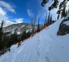
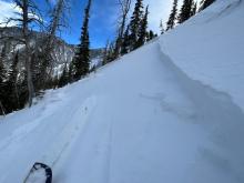
Caught: 0 ; Buried: 0
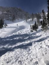
We were skiing in the northern absarokas yesterday, and triggered a number of slow moving sluffs in the new snow that slid easily on the thick crust formed from the warmup last weekend. The sluffs were triggered in isolated steeper terrain (>38deg) but were able to pick up enough momentum to travel a ways downslope. We figured that a few more inches of load in the form of the new snow last night or windslabs forming on the ridgelines would make them more difficult to manage. We saw some shooting cracks at ridgelines due to wind slab development, but the attached image shows sluffs that traveled a fair bit down the slope, but didn’t propagate wider than the area affected by our skis.
More Avalanche Details
SS-ASc-D1-I
Elevation: 10,602
Aspect: N
Coordinates: 45.3501, -111.3900
Caught: 0 ; Buried: 0
From obs: "Today my partner and I skied the Peruvian Face on the N side of 10,602 in Beehive Basin. We originally were going to ski Bolivia. I went out into the start zone on belay and decided to turn around due to an 8” hard slab on what appeared to be a decomposing, unsupportable sun crust. We then scrambled the ridge to the top of Peru. After the good ol throw a rock and see what happens test, the start zone appeared to be soft and slightly loaded. I made a ski cut across the top of the path and pulled out a 6-8” wind slab 30’ wide and ran 3/4 of the path. We then skied variable snow/debris to the bottom. There was evidence of wet loose activity from the previous warming on many aspects in the south fork of Spanish creek"
More Avalanche Details
L-AS-R2-D1.5
Coordinates: 45.1628, -111.5290
Caught: 0 ; Buried: 0
Observation from the Y-couloir on Black Mountain in the Absarokas (outside of the advisory area) 4/1/22:
"Crown was 4-6” deep, approximately 30’ across (just shy of the width of the couloir). Ran the length of the couloir (~700’). Layer that slid consisted of new, unconsolidated snow. The slide was skier-triggered, skier stayed on his feet as it ran by them. We dug a pit beforehand on a similar aspect and got ECTPN. New snow concerns matched that of the forecast for today."
More Avalanche Details
WS-N-R2-D2.5-G
Elevation: 7,200
Aspect: S
Coordinates: 45.5364, -112.0030
Caught: 0 ; Buried: 0
Observed on 4/2/22. Observers noted the slide appeared to be a few days old and took out mature timber.
More Avalanche Details
WL-N-R2-D2-O
Elevation: 8,800
Coordinates: 44.7292, -111.3230
Caught: 0 ; Buried: 0
We observed many wet snow avalanches in the Targhee Creek drainage near Lionhead Ridge that likely occurred between 3/26 and 3/29. Most slides initiated as wet, loose avalanches. One ran ~1000' vertical, but most were small due to terrain.
More Avalanche Details
WL-N-R1-D2-O
Aspect: E
Coordinates: 45.7668, -110.9440
Caught: 0 ; Buried: 0
This natural wet, loose avalanche on the east face of Baldy Mtn in the Bridger Range likely released on March 27.
More Avalanche Details
WS-N-R2-D2-O
Coordinates: 45.0202, -109.9380
Caught: 0 ; Buried: 0
Skiers noted recent wet slab and wet loose avalanche activity on March 28th in the mountains near Cooke City. Most likely occurred on 3/27.
More Avalanche Details
WS-AE-R4-D2
Elevation: 8,400
Aspect: NE
Coordinates: 45.2311, -111.4410
Caught: 0 ; Buried: 0
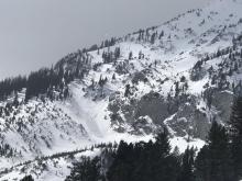
"We also conducted avalanche mitigation on our Cabin’s Road at 4:30pm. The snowpack in this zone doesn’t get skied and is representative of the backcountry. The slope is ENE around 8,400’. Several wet slab avalanches were produced with explosives and ski cutting. The avalanches ranged from R4/D2 to R2/D1. They all hit the road and several crossed, and buried, the Cabin’s Road. Although most of this mitigation was done with explosives, it took minimal effort with skis to get snow moving. The crowns were 2-3’ deep and ran on the ground."
More Avalanche Details
WL-N-R2-D2-O
Elevation: 8,500
Coordinates: 45.8156, -110.9230
Caught: 0 ; Buried: 0
Ski patrols at Bridger, Big Sky and Y.C. observed many natural wet slabs and wet loose avalanches in closed terrain, and nearby backcountry terrain, throughout the day on 3/27/22.
More Avalanche Details
WS-N-R2-D2-O
Elevation: 9,000
Coordinates: 44.9977, -109.9780
Caught: 0 ; Buried: 0
On 3/27/22 we saw a natural wet slab crown on Wall Mtn. south of Silver Gate. It appeared less thanb 24 hours old, maybe occurred earlier in the day. Later in the day we saw a wet slab crown on the south side of Mineral Mtn. that was not there when we drove in.
More Avalanche Details
WL-N-R1-D1.5-O
Elevation: 9,000
Aspect: E
Coordinates: 44.9752, -110.0870
Caught: 0 ; Buried: 0
We observed widespread natural wet loose activity on 3/27/22 on the way into Cooke City. Slides were 8-12" deep and happened yesterday and today. While pulled over to photograph a crown we heard avalanches running on slopes nearby.
More Avalanche Details
WL-N-R2-D1.5-O
Elevation: 8,500
Aspect: E
Coordinates: 45.9196, -110.9760
Caught: 0 ; Buried: 0; Killed: 0
We observe many wet loose avalanches in the northern Bridger Range. Some of them gouged down into old snow near or at the ground.
More Avalanche Details
WS-N-R2-D2-O
Elevation: 8,000
Aspect: E
Coordinates: 45.8586, -110.9560
Caught: 0 ; Buried: 0; Killed: 0
We observed 7 natural avalanches north of Ross Peak. There was a mix of wet slab and wet loose avalanches that broke near or at the ground.
More Avalanche Details
WS-N-R2-D2-O
Elevation: 8,500
Aspect: E
Coordinates: 45.7869, -110.9350
Caught: 0 ; Buried: 0; Killed: 0
We observed 5 wet slab avalanches in Argentina Bowl that occurred naturally on March 27th. All R2D2 in size
More Avalanche Details
WS-N-R1-D1.5-O
Elevation: 9,000
Aspect: SE
Coordinates: 45.2268, -111.5120
Caught: 0 ; Buried: 0
More Avalanche Details
WL-R1-D1
Elevation: 10,000
Aspect: E
Coordinates: 45.4444, -111.0040
Caught: 0 ; Buried: 0
More Avalanche Details
WL-N-R2-D2-G
Coordinates: 45.0080, -110.8370
Caught: 0 ; Buried: 0
From obs 3/26/22: "Freezing temps overnight created breakable crust in the morning which quickly deteriorated as the day warmed. (Temps rose surprisingly faster than we anticipated. Experience large whumphs while ascending the NW shoulder of Electric Pk. at 9600 ft. Without hesitation we turned back and skied out the skin track. The snow became very rotten and we penetrated to boot-tops often while exiting."
More Avalanche Details
WL-AS-D2-O
Coordinates: 45.2760, -111.4360
Caught: 0 ; Buried: 0
BSSP reported one wet slide that broke 3-4' deep and created a sizeable pile of debris
More Avalanche Details
WL-N-R2-D2-O
Elevation: 8,000
Aspect: E
Coordinates: 45.8156, -110.9230
Caught: 0 ; Buried: 0
Bridger Bowl ski patrol reported five natural wet avalanches that occurred in closed terrain. Many were D1-D1.5, one was R2-D2.
A small natural out of the sunnyside of lower Job 3... at 12.30pm.
[around 1:30pm] a small natural (similar in size to the Job 3 release) ran out of Baldwins Bad Idea Butress and put a very small pile on the North Bowl Road.
A small natural ran out of LeMons around 3pm, and the High-T fence between tight squeeze and never never land cliffs was taken 300ft downhill by a 2' deep wet slide release around that time.
A larger natural R2D2 ran out of Catch and Release late afternoon that left a medium sized pile of debris in Bridger Gully above the Bears.
More Avalanche Details
HS-AM-R2-D1.5-O
Elevation: 9,000
Aspect: NE
Coordinates: 44.9592, -111.3130
Caught: 0 ; Buried: 0
More Avalanche Details
N
Coordinates: 45.1153, -109.9140
Caught: 0 ; Buried: 0
On 3/26/22 skiers saw a small slab on the west face of Sawtooth Peak near Goose Creek.
More Avalanche Details
HS-R2-D2
Coordinates: 45.0773, -110.0210
Caught: 0 ; Buried: 0
Slab avalanches were observed on slopes baking in the sun near Cooke City on 3/25/22:
-A slide on the south face of Abundance that either broke naturally or was remotely triggered by a snowmobiler. Appears 3+ ft deep and 150 ft wide
-A small slide near Bull of the Woods Pass that was snowmobile triggered.
More Avalanche Details
HS-N-R2-D2-O
Elevation: 9,800
Coordinates: 45.0344, -109.9840
Caught: 0 ; Buried: 0
On 3/25/22 skier observed two natural slabs on a W-SW aspect off Miller Ridge at around 9800'.
More Avalanche Details
HS-N-R2-D2
Coordinates: 45.2771, -111.4640
Caught: 0 ; Buried: 0
Dry slab avalanche observed in the Lone Lake Cirque that broke overnight 3/23 or early 3/24.
More Avalanche Details
HS-ASu-R2-D2.5-O
Elevation: 9,500
Aspect: W
Coordinates: 44.9933, -109.9250
Caught: 3 ; Buried: 0
On March 24, 2022 a group of six skiers descended the west side of Woody Ridge near an area locally
known as KNB's. Approximately a third of the way down the slope the group triggered an avalanche that
crossed three gullies, broke 1-3 feet deep, 275 feet wide (measured on GoogleEarth) and ran 700 feet
vertical. Five skiers were stopped, watching one descend the slope. Three of the stopped skiers were in a
row of dense trees directly above and adjacent to where the slide broke and two were stopped a few
feet below the trees. The avalanche caught the skier and two members of the group who were stopped
downhill of the trees. One skier was pinned against a tree and the avalanche passed him. The second
skier slid into a tree sustaining multiple suspected rib fractures. The third, who was actively skiing, was
caught, carried and partially buried with just his arm sticking out of the snow, 500 vertical feet below the
avalanche crown. All three captured skiers successfully deployed their airbags.
The three remaining members of the group switched their avalanche transceivers to search and located
all three victims, and unburied the partially buried skier within five minutes. All members of the group
had formal avalanche training: Avalanche Level 1 and 2 up to a Pro Level 2. All members of the group had
avalanche transceivers, shovels, probes and airbags. The group performed field first aid and
self-evacuated to Cooke City.
More Avalanche Details

SS-N-R2-D2
Coordinates: 45.1153, -109.9140
Caught: 0 ; Buried: 0
Slab avalanche on Sawtooth Ridge in the Wilderness north of Cooke City. Observed 3/23 and appeared to be recent.
More Avalanche Details
WL
Coordinates: 45.4164, -110.9700
Caught: 0 ; Buried: 0
Solar input triggered small cornice collapse while booting up fat maid that ran by our group, but did not trigger anything from its impact on the slope. We saw many wet avalanches both small and large, mostly loose, but one slab that came down the south east face of Bole after skiing the pinner.
More Avalanche Details
Coordinates: 44.9752, -110.0870
Caught: 0 ; Buried: 0
While ascending the SSW ridge of Baronette - via Pebble Creek trailhead - we had 2 major collapses around 8,800' in low angle terrain. The largest collapse was roughly 50'x100' with visible cracks on the perimeter. HS on both slopes was ~120cm. S aspect. The weak layer was failing about 30cms down in facets.
Surface of the snowpack was a 2" thick melt freeze crust that supported body weight with skis on.
boot pen. - Basically the whole snowpack.
More Avalanche Details
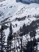
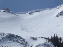
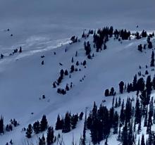
HS-NCu-R1-D2-O
Elevation: 10,000
Aspect: E
Coordinates: 45.2268, -111.5120
Caught: 0 ; Buried: 0
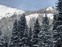
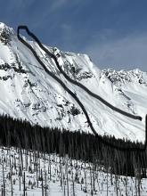
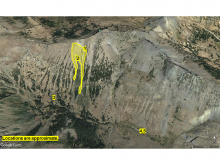
These slab avalanches were seen on the east-southeast aspect of Cedar Mountain. The smaller one on the left released around March 20. The larger ones on the right may have been cornice triggered on March 21 or 22. The photo was taken from the Yellowstone Club. Photo: S. Egan
More Avalanche Details
SS-N-R3-D1-I
Elevation: 9,800
Aspect: E
Coordinates: 45.0046, -109.9580
Caught: 0 ; Buried: 0
More Avalanche Details
SS-AM-R1-D1-I
Coordinates: 45.2268, -111.5120
Caught: 0 ; Buried: 0
More Avalanche Details
SS-AS-O
Coordinates: 45.8156, -110.9230
Caught: 0 ; Buried: 0
BBSP reported a skier-triggered avalanche north of the ski area boundary. Minimal information. No one was caught that we know of.
More Avalanche Details
SS-ASu-R2-D2
Elevation: 8,250
Aspect: E
Coordinates: 45.7943, -110.9360
Caught: 0 ; Buried: 0
A skier triggered an avalanche mid-slope on Saddle Peak in the Bridger Range early afternoon March 21st. Thankfully the individual was able to ski out of the slide.
More Avalanche Details

SS-Nu-R2-D2.5-O
Elevation: 9,000
Aspect: N
Coordinates: 44.9731, -111.3100
Caught: 0 ; Buried: 0
This natural avalanche likely released during or immediately after the storm on March 20 that dropped almost a foot of new snow. Wind-loading caused the slab over the weak faceted snow to break 500 feet wide.
More Avalanche Details

N-R2-D2
Elevation: 9,900
Aspect: NE
Coordinates: 45.2268, -111.5120
Caught: 0 ; Buried: 0
Patrollers at the Yellowstone Club spotted a natural avalanche on a steep, wind-loaded slope that failed on March 20th.
More Avalanche Details
SS-N-I
Coordinates: 45.3934, -110.9690
Caught: 0 ; Buried: 0
A snow surfer reported many natural avalanches breaking in the Divide Cirque running from wind-loaded terrain near ridgelines most of the length of the slopes. Avalanches failed at or near the interface with the 12" of snow from this weekend.
More Avalanche Details
L-ASc-R1-D1.5-I
Aspect: NE
Coordinates: 45.8301, -110.9340
Caught: 0 ; Buried: 0
From obs: "2 ski cuts in the top of the bowl and it ran most of the way to the bottom. Skiing next to the path, 4 turns would generate enough sluff that you had to get out of the way. No slab releases but the sluff could knock you down if you weren’t looking out for it."
More Avalanche Details
SS-N-R2-D1.5-I
Elevation: 9,000
Aspect: N
Coordinates: 45.4164, -110.9700
Caught: 0 ; Buried: 0
More Avalanche Details
SS-N-R1-D1-I
Elevation: 9,400
Aspect: SE
Coordinates: 45.3374, -111.3810
Caught: 0 ; Buried: 0
Small (R1) storm slabs were observed under a cliff band at the mouth of Middle Basin
More Avalanche Details
SS-NC-R2-D2-O
Aspect: N
Coordinates: 44.9855, -109.9410
Caught: 0 ; Buried: 0
Skiers spotted this natural avalanche on a north-facing slope in Republic Creek
More Avalanche Details
Coordinates: 45.3453, -111.3750
Caught: 0 ; Buried: 0
From obs: "We were one basin north of Bear basin on the NE ramp of Bear Peak (10400'). We were on an NNE aspect of the ramp taking off our skis to dig a pit when we noticed how rotten the snow was, boot pen was immediately up to our waste. My partner noticed a subtle collapse and a couple of seconds later we both felt and audibly heard a larger collapse. There were a few shooting cracks about 5-8 feet up the slope from us and arcing about 10 feet across the slope. We gingerly put our skis back on and traversed down and away from to a low-angle bench.
Digging hasty hand pits and probing with our poles we continued to notice hard crusts and slabs with weak snow beneath them on E and NE aspects protected from the sun but less so on anything slightly south-facing or west. During a quick column test on a SE aspect at about 10,200', the result was CT14."
More Avalanche Details
SS-NC-R2-D2-O
Elevation: 9,000
Coordinates: 44.7145, -111.3180
Caught: 0 ; Buried: 0
We saw two natural avalanches on 3/19/22 appeared to be within 24-48 hours old and triggered by cornice falls that broke out a slab below. One on Northeast aspect at 8,800' on Lionhead Ridge, and one on North aspect at 10,000' behind Targhee Creek.
More Avalanche Details

SS-N-R2-D2-O
Elevation: 9,500
Aspect: NE
Coordinates: 45.0465, -109.9770
Caught: 0 ; Buried: 0
Slide observed on Miller mountain, on a NE face on 3/18/22. R2-D2-O
Slide Observed on North Face of Crown Butte. Possibly a cornice collapse. R1-D1-S
More Avalanche Details
SS-N-R2-D2-I
Coordinates: 45.1153, -109.9140
Caught: 0 ; Buried: 0
"Natural wind slab near Goose Lake on peak 11175, R2-D2 ran 300' 12" crown E aspect. Multiple naturals on Sawtooth Mt. mid elevation. Lots of dry loose point release on S, E and W aspects" - Beartooth Powder Guides
More Avalanche Details
SS-AS-R2-D1.5-I
Elevation: 9,500
Aspect: E
Coordinates: 45.0773, -110.0210
Caught: 0 ; Buried: 0
From obs. 3/18/22: "Slide which looks to be triggered by a skier or snowboarder, on an east facing slope of Mount Abundance. Slide pictured was estimated 100 feet wide, and 12" deep, and ran a couple hundred feet. If you look to the right, on the slope, another crown can be seen, which was equal size to this one."
More Avalanche Details
SS-ASu-R1-D1.5
Elevation: 8,000
Aspect: N
Coordinates: 45.3765, -111.2460
Caught: 1 ; Buried: 0
Skier triggered slide on north-facing slopes above Lava Lake. Skier was caught, but not buried.
Video: https://youtube.com/shorts/pRW5XvtBY6E
More Avalanche Details

N-R2-D2
Elevation: 8,950
Aspect: E
Coordinates: 45.7943, -110.9360
Caught: 0 ; Buried: 0
We observed a natural avalanche on Saddle Peak on our drive home today. The Bridger Range received 7" of heavy snow equal to 1" of snow water equivalent in the last 24 hours. During the day we saw heavy wind-loading occurring on the high peaks of the range including Saddle.
Bridger Bowl Ski Patrol noted a few slides in the morning (one cornice triggered), estimated 2' deep.
"...cornice triggered slide on saddle today. Broke a couple of feet deep, and I couldn’t get too close to the crown but it seemed to have initially broken in the new snow and then stepped down to a PWL below the recent crust...propagated maybe 130ft wide and ran all the way over the saddle cliff to the flats."
More Avalanche Details
N
Coordinates: 45.2268, -111.5120
Caught: 0 ; Buried: 0
The Big Sky Ski Patrol saw this natural avalanche as it occurred. "This morning around 8:45AM myself and my route partner were doing control work in hanging valley. I watched as he prepared a shot and saw a big cloud of snow on Cedar behind him. As I was looking I saw an avalanche appear from below the blowing snow. I watched it run from near the top of the ridge to the runout approximately 800-1000 ft below. It looked like most of the bowl was involved in the avalanche so I estimate the crown to be likely 1000ft wide. It looked to not be an enormous amount of volume so I estimate it to be likely between 6in and 2ft. We did not get a good view of crown as weather moved in shortly after and winds were strong."
More Avalanche Details
SS-N-R2-D1-I
Elevation: 9,000
Aspect: SE
Coordinates: 45.0999, -109.8840
Caught: 0 ; Buried: 0
Skiers near Zimmer Creek observed a couple natural avalanches that occurred during the day and early this morning on 3/14/22.
Another group reported: "Avalanche on Mt Fox, E aspect that likely ran on the same layer. Visibility was too poor for a photos. D2-R1 ran aprx 400' feet and crossed the bench at its Southern edge for about 100'."
More Avalanche Details
SS-ASr-R1-D1-I
Elevation: 9,000
Aspect: SE
Coordinates: 45.0999, -109.8840
Caught: 0 ; Buried: 0
"skier remote trigger while performing a ski cut, also in Butter. All slides [observed today] were D1, storm slab on mfcr, solar aspects
Also observed a couple large wumpfs and cracking on lower angle slopes. This new snow warmed up significantly today, pretty touchy out there."
More Avalanche Details
SS-AS-R1-D1.5-O
Elevation: 10,000
Aspect: E
Coordinates: 45.4444, -111.0040
Caught: 0 ; Buried: 0
Multiple avalanches were observed on the East face of Mt. Blackmore on 3/14/22. The avalanche depicted on looker's right was triggered by a ski cut 50' above the crown.
More Avalanche Details
R2-D1-O
Elevation: 9,400
Aspect: E
Coordinates: 45.2125, -111.2480
Caught: 0 ; Buried: 0
This slide was triggered 3/14/22 by snowmobilers at Buck Ridge. The slide was triggered Monday afternoon by us climbing up the slightly lower angle slope to the left. It was an East facing slope at 9400’ above Muddy Creek drainage.
More Avalanche Details
SS-N-R2-D2-I
Elevation: 9,500
Coordinates: 45.0202, -109.9380
Caught: 0 ; Buried: 0
We saw a few recent natural avalanches while riding north of Cooke City on 3/14/22. One on Crown Butte appeared to have run yesterday. A couple in the Rasta Chutes on Scotch Bonnet looked like they broke early this morning.
More Avalanche Details

Elevation: 8,000
Aspect: NE
Coordinates: 46.0187, -110.2760
Caught: 0 ; Buried: 0
From IG: "Avalanche in the crazies that caught and carried me today. There were quite a few cars at the trailhead so I thought I’d share so maybe more people knew what the crazies snowpack is like.
Hard wind slab on a NE aspect at 8000ft. The whole seam was about 300feet wide and the toe was maybe 100 feet below the crown at the furthest. Collapsed on buried surface hoar on top of a freeze crust."
More Avalanche Details
SS-N-R3-D2-I
Elevation: 9,000
Aspect: SE
Coordinates: 45.0202, -109.9380
Caught: 0 ; Buried: 0
Numerous 10-12" SS remote triggered avalanches on anything steep enough to slide where the new snow fell on solar crust. [Natural on] the cliffs on the north side of Companion Lake as you leave the lake heading for the wilderness boundary. Had not avalanched on the way out in the morning, noticed the avalanche on the way back this afternoon. Another avalanche skier triggered on intentional test slope with a solar tilt in the Alp Gulley."
More Avalanche Details
HS-ASu-R3-D2-O
Elevation: 9,800
Aspect: SE
Coordinates: 45.2760, -111.4360
Caught: 1 ; Buried: 0; Killed: 0
A skier reported triggering and getting caught in an avalanche that broke widely across "Wyoming Bowl" in the backcountry outside of Big Sky Resort. The avalanche dragged the skier over rocks and thankfully he is walking away with only bruises. The avalanche broke ~500' wide x 18" average depth x 300' vertical on a heavily wide loaded slope.
More Avalanche Details

SS-AM-D1.5
Coordinates: 45.1719, -111.3800
Caught: 0 ; Buried: 0
On March 12, riders at Buck Ridge triggered 3 slides from the base of small hills. They also observed two natural avalanches and one other slide triggered by a snowmobiler.
More Avalanche Details
Coordinates: 45.8586, -110.9560
Caught: 0 ; Buried: 0
From obs 3/12/22: "A group of four of us were hoping to ski the banana couloir on Ross Peak today, knowing wind loading would likely be an issue. We approached from the east (?) ridge, and gained enough elevation to cross the face towards the entrance of the line. Upon exiting the protected ridge towards the face (about ~100 ft from the entrance to the banana) we experienced shooting cracks on the heavily cross loaded slope. The wind was blowing heavily and swirling, coming predominately out of the Southwest, which was odd. We decided to turn around and enjoy some highly variable meadow skipping back to the car."
More Avalanche Details
HS-ASu-R2-D1.5-O
Elevation: 7,500
Coordinates: 45.9196, -110.9760
Caught: 0 ; Buried: 0
From obs 3/12/22: "Upon descending a ~35 degree slope, I (the snowboarder) kicked loose a wind slab that propagated 100 feet wide, 8 inch deep (max, 4 inches at edges) wind slab that traveled approximately 300 feet (entire slope over 30 degrees) before settling in 2 debris fields, each about 30’ wide and with a maximum of 2’ depth. No one was swept by the debris/buried/injured."
More Avalanche Details
SS-N-R3-D1.5-O
Elevation: 9,500
Aspect: S
Coordinates: 45.0202, -109.9380
Caught: 0 ; Buried: 0
On 3/12/22. We saw 5+ avalanche crowns that appeared to have broke naturally, and got reports of a few others. All were 6-10" deep, recent wind-drifted snow failing on a hard melt-freeze crust.
More Avalanche Details

SS-AM-R2-D1-O
Elevation: 9,500
Aspect: S
Coordinates: 45.0733, -109.9480
Caught: 0 ; Buried: 0
We witnessed a recently triggered slab near Sheep Mtn. on 3/12/22, and a rider reported triggering a slide on Scotch Bonnet near Lulu Pass.
More Avalanche Details
SS-ASr-R3-D1-O
Elevation: 9,000
Aspect: S
Coordinates: 45.0999, -109.8840
Caught: 0 ; Buried: 0
Skiers remote triggered a soft slab on a S facing slope. Broke about 8 inches deep on the mfc
More Avalanche Details
SS-ASu-R1-D1
Coordinates: 45.4444, -111.0040
Caught: 0 ; Buried: 0
From obs (3/10/22): "Today we triggered a small pocket of wind loaded snow while ascending (bootpacking) the East ridge of Blackmore. The convexity broke about 1 foot down and propagated about 10 feet wide. It ran the entire distance of the East face ~800’. "
A second report noted additional skier triggered wind slabs on Mt. Blackmore.
More Avalanche Details
SS-AS-R1-D1-I
Elevation: 8,500
Aspect: E
Coordinates: 45.4480, -110.9980
Caught: 0 ; Buried: 0
Ski toured up to Blackmore today.
On the way in we noticed a skier triggered soft slab on the short west facing shots as you approach the meadow. (attached is the photo - SS-R1.5-D1-I).
More Avalanche Details
HS-N-R1-D1.5-I
Aspect: NE
Coordinates: 45.0524, -109.9450
Caught: 0 ; Buried: 0
Thin wind slab avalanche on a NE aspect of Henderson Mountain. Approx 100ft wide. Likely broke on 3/8/22 observed 3/9/22.
More Avalanche Details
Elevation: 9,000
Aspect: E
Coordinates: 45.7943, -110.9360
Caught: 0 ; Buried: 0
Natural activity was observed on Saddle Peak, with debris travelling full path Between the Peaks.
More Avalanche Details
SS-ASc-R1-D1-O
Elevation: 8,000
Aspect: N
Coordinates: 45.5243, -110.9560
Caught: 0 ; Buried: 0; Killed: 0
As we moved along a steep break over near Lick Creek, we triggered shooting cracks and an avalanche on a small test slope. The avalanche slide on a hard melt-freeze crust formed last week.
More Avalanche Details

HS-AMu-R2-D2-O
Elevation: 10,000
Aspect: N
Coordinates: 45.0754, -109.9500
Caught: 0 ; Buried: 0
Riders saw the crown and debris of an avalanche on the north side of Scotch Bonnet on 3/6/22. It appeared to have happened that day or within 24 hours.
More Avalanche Details
Elevation: 9,500
Aspect: E
Coordinates: 45.4272, -111.0140
Caught: 0 ; Buried: 0
From obs 3/6/22: "Skinned out to Alex Lowe peak today. Dug a pit on a northeast aspect below the east face of the peak. Got an ECTP 24 to break around 20 cm down. The slab was a knife hard sun/wind crust. Continued up avoiding areas where we noticed that bullet hard crust under the surface. On our decent we skied off the east ridge below the summit and on a skit cut got some shooting cracks, and a small wind slap to propagate but not slide. Skied the rest of the way down and didn’t notice anything else."
More Avalanche Details
SS-AS
Coordinates: 45.0254, -110.0310
Caught: 0 ; Buried: 0
Skiers had a large collapse (approx. 50' wide) in Pebble Creek on 3/5/22.
More Avalanche Details
SS-ASr-R2-D2-O
Elevation: 8,600
Aspect: SE
Coordinates: 44.9952, -109.9080
Caught: 0 ; Buried: 0
Reported to BPG on Saturday 3/5.
More Avalanche Details
SS-N-R2-D2-O
Elevation: 8,900
Aspect: E
Coordinates: 45.0254, -110.0310
Caught: 0 ; Buried: 0
Avalanches in Pebble Creek near Cooke City. Likely occurred on March 3rd, due to the very warm temps. Easterly aspects, around 8900'. Approx 1' deep and 50-100' wide.
More Avalanche Details
WL-N-D2
Coordinates: 44.8949, -111.2280
Caught: 0 ; Buried: 0
Multiple natural large wet slides were observed near Quake Lake and Cabin creek which likely occurred on 3/3, maybe 3/4.
More Avalanche Details
SS-N-R2-D2
Aspect: E
Coordinates: 44.9855, -109.9410
Caught: 0 ; Buried: 0
3 fresh natural slab avalanches were seen on E aspects in Republic Creek, 8500-9400’ in elevation, that broke on 3/3/22. These slab avalanches were 1-2' deep and up to around 100' wide. One appears to have been triggered by a pine marten.
A half dozen small slabs released off the mid elevation south aspects of Mineral Mtn and a large slide broke on the NE aspect and ran 1600 ft.
A natural avalanche was seen on Climax in Hayden Creek - broke approximately 100 ft wide an ran over cliffs and rocks.
More Avalanche Details
WL-N-R1-D1
Coordinates: 44.7145, -111.3180
Caught: 0 ; Buried: 0
Numerous small wet loose avalanches were seen in the Lionhead area on 2/3/22. These slides generally started below rocks and did not entrain much snow.
Wet loose avalanches were also reported in Hyalite and near Cooke City.
More Avalanche Details
SS-N-R1-D2
Coordinates: 44.7145, -111.3180
Caught: 0 ; Buried: 0
Wind slab avalanche on Lionhead Ridge. Approximately 50 ft wide and ran 200 vertical feet. Looks to have gouged down into lower layers below the rocks. Photo taken the morning of 3/2/22 and the slide looked fresh.
More Avalanche Details
WL-N
Elevation: 8,000
Coordinates: 44.9756, -110.0310
Caught: 0 ; Buried: 0
Lots of natural, small wet loose avalanches below 8k today. 4-5” of wetting.
More Avalanche Details
SS-ASu-R2-D1.5-O
Coordinates: 45.0923, -109.9510
Caught: 1 ; Buried: 0
From Obs: "A group of six of us were sled-skiing in Goose Creek today and I triggered a soft-slab avalanche on a wind loaded slope. We had skied 3-4 runs in the trees before lunch and had seen little to no signs of instability. We'd come to this area three days earlier to dig pits and found the PWL noted in avalanche report for Cooke City. There was an older crown about ~5 days old clearly visible in the bowl we decided to ski after lunch. I dropped in and skied off a cliff just to lookers left of the crown "triangle" and when I landed I triggered the avalanche. It broke roughly 60 feet wide with a crown depth of 12-16". I was able to self arrest less than 20 seconds after the avalanche started and the snow slid around me. I lost a ski but was otherwise unharmed. I also had an airbag but did not need to pull it."
More Avalanche Details
HS
Coordinates: 45.0379, -111.0600
Caught: 0 ; Buried: 0
From obs 2/27/22: "Shooting cracks in a thin wind slab on a ridge crest. The slab was small but the collapse was abrupt and propagated 20 feet."
From a group on Flanders Mtn in Hyalite: "I triggered a shallow 2-3cm deep windslab about 20 feet wide just below the ridgeline. I was not on a steep slope, so it barely moved. "
More Avalanche Details
SS-AS-O
Elevation: 10,150
Aspect: SW
Coordinates: 45.0733, -109.9480
Caught: 0 ; Buried: 0
On 2/27/22 while touring near the top of Rasta Chutes on Scotch Bonnet Mtn. near Cooke City we triggered a collapse of the snowpack and heard a loud "whumph". A 8-10" slab failed and propagated on a layer of weak, sugary facets on top of a hard melt-freeze crust. Estimated 40 feet wide.
More Avalanche Details
HS-AM-R2-D1.5-O
Elevation: 10,000
Aspect: NW
Coordinates: 45.0722, -109.9280
Caught: 0 ; Buried: 0
We saw this avalanche the afternoon of 2/27/22, on a north facing slope on Sheep Mtn. near Cooke City. It appeared less than 24 hours old and likely snowmobile triggered.
More Avalanche Details
SS-ASc-R1-D1
Aspect: SE
Coordinates: 45.4444, -111.0040
Caught: 0 ; Buried: 0
From obs: "We also found a thin to medium wind crust (1-5cm) on east and northerly slopes ATL. Our descent took us down the SE face and off the opposite shoulder from our snow pit down a north-facing chute. There was an obvious wind effect on the snow surface and we found the same wind crust/slab. Upon a ski cut, I released a very small slab that entrain a decent about of snow by the time it stopped ~600 vert. feet lower. It was the thin wind slab sliding on softer snow underneath. There was an already reported, similar avalanche from the same day higher on the face of Blackmore that ran a bit further and bigger. It seems like it had pretty much the same characteristics."
More Avalanche Details
HS-AS-R1-D1-O
Elevation: 8,300
Aspect: NE
Coordinates: 45.8512, -110.9480
Caught: 0 ; Buried: 0
From message 2/27/22: "Skier triggered yesterday in a northeast wind loaded pocket on baldy in S Bridgers. About 6 inches deep and 100ft wide.
Quite a bit of shooting and cracking elsewhere at lower elevations. Felt wind loaded just about everywhere after those east winds."
More Avalanche Details
SS-AS-R1-D1
Elevation: 10,000
Aspect: E
Coordinates: 45.0709, -109.9580
Caught: 0 ; Buried: 0
Photo is of a slide that was triggered by a skier on 2/26/22 on Rob's Knob near Lulu Pass. We saw 3 other similar sized slides on 2/27/22 while riding between Lulu Pass and Goose Creek.
More Avalanche Details
SS-AMu-R3-D1.5-O
Elevation: 9,000
Aspect: SE
Coordinates: 45.0923, -109.9510
Caught: 0 ; Buried: 0
This slide was triggered by a sledder on 2/26/22 around 1pm near Goose Creek outside Cooke City.
More Avalanche Details
SS-ASu-R1-D1
Elevation: 9,700
Aspect: E
Coordinates: 45.4444, -111.0040
Caught: 0 ; Buried: 0
obs. 2/26/22: "This is a slide that was triggered today at Mt. Blackmore. Nobody was hurt...”
More Avalanche Details
HS-ASu-R1-D1.5-O
Elevation: 8,300
Coordinates: 45.9196, -110.9760
Caught: 1 ; Buried: 0
From email 2/26/22: "Skiing in the Northern Bridgers today, one skier in our party of three triggered an avalanche in October bowl. The slide was approximately 40 yds wide and ran around 150 yds. The skier was carried approximately 100 yds, but was not buried and sustained no injuries. Neither of the other members of our party were in the slide path when it occurred."
More Avalanche Details
HS-ASr-R2-D2-O
Elevation: 8,400
Coordinates: 45.9196, -110.9760
Caught: 0 ; Buried: 0
From obs. 2/26/22: "Hey guys wanted to report a few avalanches we set off in the northern bridger range today, while skiing off of Seitz Peak. We skied the couloir (on horrible wind-scoured snow) without incident, then skied out onto the fan. I got a dozen or so turns in when the slope propagated 200’ below me, roughly 400’ wide. I skied off to the side to let it pass and watched it break sympathetically 200’ above my original trigger point, 12-18” thick at the thickest point. Overall 600’ wide, 8-18” thick, and ran over 1000 vertical feet. On our way down out of the bowl both my partner and I were able to break off more slabs through remote triggers, 50-100’ away getting them to break 8-12” deep and 100-200’ wide. All the slides broke on a layer of small grain facets in the new snow/old snow interface. We bailed on our other objectives for the day and skinned back out to the sled. Very touchy out there today!"
More Avalanche Details
HS-ASr-R3-D1.5-O
Elevation: 8,000
Aspect: NE
Coordinates: 45.9391, -110.9780
Caught: 0 ; Buried: 0
From obs 2/26/22: "We were stopped on a flat bench on top of a steep rollover... when we heard a whumpf, and then a hard wind slab released on the slope below us and ran into the trees below. We then decided to enter the avalanche at the bottom of the debris to look at the crown, where we observed that the slab was about 60cm deep at its deepest, and ran around 50 feet wide, wrapping across a small aspect change. We did two ECT tests and observed propagation on the layer during isolation in both tests... We identified a P hard wind slab overlaying a 3 cm deep layer of 1F hard facets. The layer below the avalanche interface was F hard facets. After this result, we dialed back our ski plans for the day." Photo: M. Beck
More Avalanche Details
SS-AMu-R1-D1.5
Coordinates: 44.9115, -111.1940
Caught: 0 ; Buried: 0
Snowmobile triggered slides in Teepee Basin on 2/25/22.
From obs on 2/25/22: "18 inches of new snow from last week slid on top of crust layer. The slide on the left was triggered by an uphill snowmobile hill climber, the slide on the right occurred when snowmobile turned out of a hill climb and his track broke through the crust layer causing everything with in his up and downhill track to slide."
More Avalanche Details
Coordinates: 45.3688, -111.4120
Caught: 0 ; Buried: 0
Small skier triggered slides on Blaze Mountain.
From obs on 2/25/22: "I did get a couple new wind pillows to break and move somewhat forcefully while walking near the summit of Blaze, in an area with a very shallow snowpack. These were sitting on top of some large, old facets, and while they were relatively small, they definitely could have knocked me down in more consequential terrain."
More Avalanche Details
SS-N
Coordinates: 45.0254, -110.0310
Caught: 0 ; Buried: 0
Small natural avalanche in Yellowstone National Park, near Cooke City. Observed on 2/23/22. Exact timing of the slide in unknown.
More Avalanche Details
Coordinates: 44.9739, -109.9240
Caught: 0 ; Buried: 0
I had two whumps and shooting cracks of small wind slabs (10cm thick) near the top of Woody Ridge on a W aspect. The top of Woody usually has a weak and thin snowpack and gets scoured or loaded, so I wasn't surprised.
No other signs of instability observed.
More Avalanche Details
L-N-R0-D1-O
Coordinates: 45.4272, -111.0140
Caught: 0 ; Buried: 0
I did a loop around Alex Lowe and Blackmore today...There was a 5-10mph breeze near ridgelines, and other places were dead calm...I noticed a number of small to medium natural sloughs, some of which could have had the power to knock someone over.
More Avalanche Details
L-N-R1-D1-S
Elevation: 8,500
Aspect: E
Coordinates: 45.8822, -110.9520
Caught: 0 ; Buried: 0
More Avalanche Details
SS-AMu-R2-D2-O
Elevation: 10,000
Aspect: S
Coordinates: 45.0773, -110.0210
Caught: 0 ; Buried: 0
Riders spotted this large avalanche on the south face of Mount Abundance on President's Day. It was unknown whether it was natural or human-triggered. The group had some sled issues on their way to go check on the situation and retreated to town.
We later determined that it was sledder triggered based on video footage on social media
More Avalanche Details

SS-AMu-R3-D2-O
Coordinates: 45.0202, -109.9380
Caught: 0 ; Buried: 0
A group was riding near Round Lake and triggered an avalanche that broke 200' wide by 24" deep and ran the full 50' vertical of the slope. The group estimated the debris pile was 5' deep and would have easily buried someone. Thankfully, no one was hurt.
More Avalanche Details
SS-AMu-R3-D3-O
Elevation: 9,800
Aspect: S
Coordinates: 45.0390, -109.9810
Caught: 1 ; Buried: 1; Killed: 1
On February 19, 2022, three snowmobilers and two snow bikers were in Sheep Creek on the south face of Miller Mountain north of Cooke City. The two snow bikers were high on the slope when one stopped on a small ridge while the other climbed higher and triggered a large avalanche. The avalanche carried him down through a gully and over a cliff where he was partially buried near the toe of the debris. His arm and airbag were visible and his head was 1 foot under the surface. Resuscitation efforts were unsuccessful. The avalanche was 800 feet wide, averaged 2 feet deep (estimated) and ran 1200 vertical feet. The avalanche likely broke on facets and depth hoar at the bottom of the snowpack in an area that was thinly covered and recently wind-loaded. The debris was up to 15 feet deep. The avalanche is classified SS-AMu-R3-D3-O.
CLICK HERE FOR THE FULL REPORT
More Avalanche Details

SS-ASc-R2-D1.5-I
Elevation: 8,500
Aspect: SE
Coordinates: 45.0256, -109.9370
Caught: 0 ; Buried: 0
From IG message: "I initiated a ski cut below a cornice and roller, and was able to trigger a wind slab that broke roughly 15 inches deep and 30-50 feet across and slid a few hundred feet down slope. Same problem from last night, but more volume and energy today."
More Avalanche Details
SS-ASc-R1-D1-I
Elevation: 8,700
Aspect: S
Coordinates: 45.0256, -109.9370
Caught: 0 ; Buried: 0
From message: "went for two runs off town hill [last night, 2/18/22]. ECTP14 1.5 feet down on a true south aspect. Also managed to trigger a few small soft slabs around rollers (15 feet wide, ran about 15 feet downhill), the biggest one was about 1 foot deep at the crown". Photo: T. Saulnier
More Avalanche Details
SS-ASc
Coordinates: 45.9233, -110.9800
Caught: 0 ; Buried: 0
From email 2/18/22: "Went to Fairy Lake today. Booted up totally wind-bared grass to the top of love chutes, skied those. They were pretty much wind board, though there might have been a few places with some drifted snow that was slabby. Then we skinned up the basin to Frazier lake and saw lots of very reactive little wind slabs.... Throughout most of the terrain in Frazier around treeline there was wind slab everywhere."
More Avalanche Details
L-NC-R1-D1.5-S
Elevation: 10,000
Aspect: SW
Coordinates: 45.0721, -109.9540
Caught: 0 ; Buried: 0
From email: "Observed what looked to be a natural release avalanche below a cornice on the upper aspects (northwest) of Scotch Bonnet today. Didn’t get too close to it , but would estimate it ran up to 50ft wide and a few hundred feet down slope from the cornice where it released."
More Avalanche Details
SS-ASc-R1-D1-I
Elevation: 10,000
Aspect: SE
Coordinates: 45.4029, -110.9760
Caught: 0 ; Buried: 0
More Avalanche Details

SS-N-R1-D1.5-I
Elevation: 9,975
Aspect: SE
Coordinates: 45.4029, -110.9760
Caught: 0 ; Buried: 0
More Avalanche Details
SS-N-R1-D1-S
Coordinates: 45.1719, -111.3800
Caught: 0 ; Buried: 0
3 small storm slab avalanches were observed along Buck Ridge on 2/17/22. These slides broke <6" deep within the new snow and were less than 50 ft wide.
More Avalanche Details
SS-N-R1-D2-I
Elevation: 8,700
Aspect: NE
Coordinates: 45.7869, -110.9350
Caught: 0 ; Buried: 0
From email: "Saw several recent avalanches on the east side of Saddle Peak on my drive up to Bridger this morning. All looked like naturals, I'd guess most were size R1D1 and one R1D2."
GNFAC forecasters saw the same slides which looked to involve the new snow. Most were R1-D1 dry loose and cornice falls, and there was one R1-D2 in Argentina Bowl that was likely a storm slab.
More Avalanche Details
L-N-R1-D1-S
Elevation: 8,600
Aspect: E
Coordinates: 45.7943, -110.9360
Caught: 0 ; Buried: 0
From email: "Saw several recent avalanches on the east side of Saddle Peak on my drive up to Bridger this morning. All looked like naturals, I'd guess most were size R1D1 and one R1D2."
GNFAC forecasters saw the same slides which looked to involve the new snow. Most were R1-D1 dry loose and cornice falls, and there was one R1-D2 in Argentina Bowl that was likely a storm slab.
More Avalanche Details
SS-AM-R1-D1-O
Aspect: N
Coordinates: 45.0202, -109.9380
Caught: 0 ; Buried: 0
From FB message: "north facing slope small avalanche about 30foot wide two feet deep slide around 75 yards down. This was human triggered and it was triggered saturday the 12 at around 4:30 pm."
More Avalanche Details
SS-AS-R2-D2-O
Elevation: 9,400
Aspect: SE
Coordinates: 45.0202, -109.9380
Caught: 0 ; Buried: 0
From email: "I observed what looked to be a fresh skier triggered avalanche yesterday late afternoon. And photographed it this morning, while on the highway in Silver Gate (attached). I am pretty sure it happened yesterday, Feb. 12th.
It's a SE aspect, at about 9400'."
More Avalanche Details
SS-NC-R2-D2-O
Elevation: 9,800
Aspect: NE
Coordinates: 44.9815, -109.9740
Caught: 0 ; Buried: 0
From obs 2/12/22: "N-SS-R2-D2-i. Appeared to have happened early in the early morning of 20220212."
More Avalanche Details
C-NC-R1-D1-O
Elevation: 10,500
Aspect: SE
Coordinates: 45.2268, -111.5120
Caught: 0 ; Buried: 0
Seen on 2/12/22 looked to be within 24 hours old.
More Avalanche Details
Elevation: 9,242
Coordinates: 44.9899, -109.9650
Caught: 0 ; Buried: 0
I was touring on the west side of Wyoming creek today. Got some large whoomfs and collapses on the Ridgeline and a poor test score of ectp11 q1 sp 22cm deep on on buried surface hoar on top of facets on an E/SE facing slope at 9242' hs-163cm, slope angle 26° The same layer was easily identifiable in hand shears throughout the day.
More Avalanche Details
SS-N-R1-D1.5-O
Elevation: 8,800
Coordinates: 45.0254, -110.0310
Caught: 0 ; Buried: 0
From obs: "Naturals from Pebble today. Appeared to be failing on the SH 20cm down. I dug at 8800’, SE, HS150, ECTP11, failing on 2mm SH that’s sitting on top of 20-30 cm of small grain facets. Multiple hand pits failed during isolation on same layer."
More Avalanche Details
SS-NC-R2-D2-I
Elevation: 10,000
Aspect: SE
Coordinates: 45.0733, -109.9480
Caught: 0 ; Buried: 0
We saw a natural avalanche on 2/7 that appeared to occur late on 2/6 or early 2/7, on the southeast side of Scotch Bonnet Mtn. - GNFAC
More Avalanche Details
SS-N-R2-D1.5-I
Elevation: 9,200
Aspect: NE
Coordinates: 45.0923, -109.9510
Caught: 0 ; Buried: 0
Natural avalanches released on or before 2/6/22 in Goose Creek.
More Avalanche Details
SS-AMr-R2-D2-O
Coordinates: 45.1153, -109.9140
Caught: 0 ; Buried: 0
From email: "This remotely triggered slide up near goose lake was small but high consequence in this terrain. The trigger point is below the group of trees on the lookers left of the photo."
More Avalanche Details
SS-AMu-R2-D2-O
Elevation: 9,900
Aspect: SW
Coordinates: 45.0722, -109.9280
Caught: 0 ; Buried: 0
From Obs: "On the morning of Sunday February 6, a snowmobiler triggered a slide in new snow on the SW face of Sheep Mountain. The slide triggered remotely while the rider was lower on the slope and he was not caught (the visible track is not from the rider who triggered the slide, his track was buried in the debris field). The crown was about 18" deep and 75 feet wide and the slide and the slide ran about 250 feet."
More Avalanche Details

L-ASu-R1-D1
Coordinates: 45.4444, -111.0040
Caught: 0 ; Buried: 0
From Obs: "We skied into Blackmore late yesterday with chief concerns of the weak layer @ around 110cm and wind loaded new slopes. We dug two pits and found no failures in our column or ECTs. With the wind on the ridge we dug a hasty pit near the ridge to see how it was bonding. Again no results.
We decided to ski our lines taking care to avoid potential trigger zones and particularly loaded slopes. About half way down, I took a turn to the skier's left of a spine and the skier's right side had a small surface-level release. This would probably not have buried a skier, but likely would have taken them or a ride above the cliff band."
More Avalanche Details