Good morning. This is Doug Chabot with the Gallatin National Forest Avalanche Forecast issued on Thursday, March 28th at 6:30 a.m. Today's forecast is sponsored by Yellowstone Club Community Foundation and Bridger Bowl. This forecast does not apply to operating ski areas.
Yesterday 2” of snow fell in the Bridger Range and a trace to 1” in Hyalite and Big Sky. Winds blew westerly at 20-30 mph, but lessened to 10-15 mph overnight. At 5 a.m. wind directions are scattered: northeast in the Bridger Range, west at Big Sky and south in the southern ranges. Snowfall will start this morning and drop 2-4” by tomorrow and favor the northern areas. Temperatures will remain in the 20s and winds will shift southwest at 15-25 mph, except in the Bridger Range where they will remain northeast.

All Regions
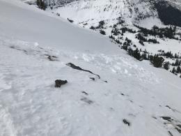
Winter is returning for a quick jab. Mountain temperatures are below freezing and snow is expected. The snowpack is stable: it is either frozen where it was previously wet, or on high elevation, northerly aspects, the snowpack is dry and strong. Our last two field days to the Bridger Range (photo, video) and Lionhead (video) confirmed the overall good stability of the snowpack. In our videos we highlighted the differences with aspect and elevation and mentioned the potential problem of new snow sluffing off the frozen crust.
Avalanche activity will be confined to today’s new snow; nothing will break deeper. The snow will easily sluff off the frozen surface and travel fast and far down the slope. Winds are expected to pick up and minor wind-drifting is possible. Of course, both these concerns only come into play if it snows. We have generally safe avalanche conditions and generally poor skiing and riding, unless of course you enjoy frozen chicken heads, then you’ll be in heaven.
For today, the avalanche danger throughout our forecast area is LOW.
If you get out and have any avalanche or snowpack observations to share, contact us via our website, email (mtavalanche@gmail.com), phone (406-587-6984), or Instagram (#gnfacobs).
Spring is here and wet snow avalanches are becoming a daily concern. Anticipate decreasing stability while forming a travel plan. This article from Backcountry Magazine highlights some things look for that indicate when it is time to turn around.