Good Morning. This is Doug Chabot with the Gallatin National Forest Avalanche Forecast on Wednesday, February 5th at 7:15 a.m. Today’s forecast is sponsored by Your Montana Chevy Dealers and Mystery Ranch. This forecast does not apply to operating ski areas.
Last night a northwest flow dropped 10” in the Bridger Range, 8” around Big Sky and 2” everywhere else. Ridgetop wind is blowing westerly at 15-20 mph with gusts of 30-40 mph. Mountain temperatures this morning range from a few degrees below zero to single digits. Today and tonight will be snowy and windy with westerly gusts hitting 40 mph. By morning I expect 8-12”of snow in most areas with Cooke City getting closer to 6”.

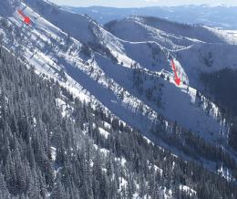
The avalanche danger is rising. Overnight almost a foot of new snow fell in the Bridger and northern Madison Ranges with strong west wind. The northern Gallatin Range has 2”, but more will fall through the day. This new snow will, 1) add weight to the snowpack, 2) increase the stress on buried weak layers, and 3) avalanche. In the last 2 days, before this added stress, avalanches occurred naturally on wind-loaded slopes south of Bridger Bowl (photo), on the west side of the Bridger Range (details and photos) and north of Ross Peak (photo), and Beehive Basin. Ian rode into Buck Ridge yesterday and got unstable results in his snowpit (video), and on Monday Dave toured into Mt. Ellis where he found weak snow that collapsed with “whumphs”. He determined the snowpack was dangerously close to avalanching (video). Today’s storm will make triggering avalanches likely on many slopes in the northern ranges. For today, the avalanche danger is rated CONSIDERABLE and could rise to HIGH if the snow storm dumps more than predicted.

The storm is just beginning in the southern mountains including Cooke City and West Yellowstone. The snowpack has a poor snow structure of weak, sugary facets near the ground. I toured above Hebgen Lake outside West Yellowstone yesterday and saw 4 stability tests break clean in 2 snowpits on this layer (video). Today’s snowstorm, if it comes to full fruition, will increase the avalanche danger. Previous activity includes a large avalanche on Skyline Ridge in the southern Madison Range that was triggered by a snowmobiler on Saturday (photos), a 3’ deep slide near Lulu Pass that Alex triggered on Thursday (video) and a deep natural slide outside Cooke City (photo). Avalanches before a storm indicate they will continue unabated during the storm. The avalanche danger is rated MODERATE but would rise to CONSIDERABLE if/when the snowstorm arrives. New snow and strong west wind will create dangerous avalanche conditions.
If you get out, please send us your observations no matter how brief. You can fill out an observation form, email us (mtavalanche@gmail.com), leave a VM at 406-587-6984, or Instagram (#gnfacobs).
Upcoming Avalanche Education and Events
Our education calendar is full of awareness lectures and field courses. Check it out and plan to attend one or two: Events and Education Calendar.
COOKE CITY
Every Friday and Saturday, Snowpack Update and Rescue Training. Friday, 6:30-7:30 p.m. at the Soda Butte Lodge. Saturday anytime between 10-2 @ Round Lake.
BOZEMAN
February 5, Women’s Specific Avalanche Awareness. 6-7 p.m. at REI.
February 7, Companion Rescue Clinic. 6 - 8 pm at REI followed by a field day February 8. More info and Register Here.
February 10, 1-hr Avalanche Awareness. 5:30 p.m. at Gallatin Valley YMCA.
WEST YELLOWSTONE
February 8, 1-hr Avalanche Awareness, 7-8 p.m. at West Yellowstone Holiday Inn.
Make it a daily habit to check out our Weather and Avalanche Log. It’s a great way to get a quick snapshot of what’s been happening in the backcountry.