AVALANCHE WARNING
The Gallatin National Forest Avalanche Center is issuing a Backcountry Avalanche Warning for the Bridger Range, Gallatin Range, Madison Range, the Lionhead area near West Yellowstone and the Centennial Range near Island Park, ID. Over a foot of heavy snowfall and strong wind are overloading a weak snowpack, creating very dangerous avalanche conditions. Natural and human triggered avalanches are likely. Avalanche terrain and avalanche runout zones should be avoided. The avalanche danger is rated HIGH on all slopes. Contact the Gallatin National Forest Avalanche Center for more detailed information.
Good Morning. This is Doug Chabot with the Gallatin National Forest Avalanche Forecast on Thursday, February 6th at 7:00 a.m. Today’s forecast is sponsored by Bridger Bowl and World Boards. This forecast does not apply to operating ski areas.
We are in the midst of a nice winter storm. At 6 a.m., the 24-hour snowfall is 10-15” from West Yellowstone to the Bridger Range, and 6” in Cooke City. Most of it fell last night. Wind has picked up and is blowing strong out of the W-NW at 20 mph with gusts of 40 mph. Snow will continue into Friday afternoon. By tomorrow morning another 12-18” will have fallen with strong W-NW wind and mountain temperatures near 20F. Today is your chance to lay a little groundwork so you can take tomorrow off. A few sniffles and well-timed cough equals a three day weekend of Pow!
Avalanche Warning
Last night, 8-13” of snow fell from the Bridger Range to Lionhead measuring .6-.8” of snow water equivalent, aka 6% powder. This is on top of the 8-10” that fell yesterday in the northern ranges. And the wind is blowing with gusts of 40 mph at the ridgetops that is loading slopes on many aspects.
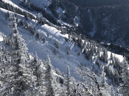
The avalanche story is simple: New snow and wind yesterday, last night and today are creating dangerous avalanche conditions. If there is visibility, which there isn’t, you would see natural avalanches breaking on wind-loaded slopes. And if you get on a steep slope you’ll likely trigger and get buried in an avalanche.
I am basing today’s elevated danger on the fact the snowstorm is near guaranteed to continue. Wind-loaded slopes should be avoided at all costs and every steep slope is untrustworthy. Avalanches will occur in the new snow and some slopes will break far and wide at the ground. Today is a day to avoid avalanche terrain. The danger is rated HIGH.
One key factor in determining today’s danger is our assessment of stability before the storm. Yesterday, Dave and Ian were in the northern Gallatin Range on Wheeler Mountain and found a weak snowpack that will struggle with the weight of new snow (video). Our field visits to Hebgen Lake (video), Buck Ridge (video) and Mt. Ellis (video) showed similar concerns: weak snow at the ground will break with a large load of new snow.

Since the storm started 30 hours ago Cooke City has gotten 8” of snow (.5” snow water equivalent) with moderate wind. A skier was able to get small cracks on wind-loaded slopes yesterday. The avalanche danger has risen with last night’s and today’s forecasted snowfall. Winds are blowing northerly at 15 mph and loading slopes where it is likely you could trigger a slide. On slopes not wind-loaded it’s possible a skier or sledder could trigger an avalanche in the new snow. Furthermore, Cooke City has a layer of weak snow at the ground that is not readily avalanching, but still could. If this layer breaks the avalanche would be large and lethal. Do not get too confident as you tour around in a snowstorm with poor visibility. For today the avalanche danger is rated CONSIDERABLE on all wind-loaded slopes and MODERATE elsewhere.
If you get out, please send us your observations no matter how brief. You can fill out an observation form, email us (mtavalanche@gmail.com), leave a VM at 406-587-6984, or Instagram (#gnfacobs).
Upcoming Avalanche Education and Events
Our education calendar is full of awareness lectures and field courses. Check it out and plan to attend one or two: Events and Education Calendar.
COOKE CITY
Every Friday and Saturday, Snowpack Update and Rescue Training. Friday, 6:30-7:30 p.m. at the Soda Butte Lodge. Saturday anytime between 10-2 @ Round Lake.
BOZEMAN
February 7, Companion Rescue Clinic. 6 - 8 pm at REI followed by a field day February 8. More info and Register Here.
February 10, 1-hr Avalanche Awareness. 5:30 p.m. at Gallatin Valley YMCA.
WEST YELLOWSTONE
February 8, 1-hr Avalanche Awareness, 7-8 p.m. at West Yellowstone Holiday Inn.
Make it a daily habit to check out our Weather and Avalanche Log. It’s a great way to get a quick snapshot of what’s been happening in the backcountry.