Good Morning. This is Doug Chabot with the Gallatin National Forest Avalanche Forecast on Thursday, March 4th at 7:00 a.m. Today’s forecast is sponsored by Yellowstone Club Community Foundation and Highline Partners. This forecast does not apply to operating ski areas.
Under clear skies at 5 a.m., temperatures are in the mid-20s F with wind averaging 5-10 mph and gusts of 20 mph out of the W-SW in the north and E-SE in the south. Today will be sunny, wind will remain light and mountain temperatures will reach the low 40s, a few degrees warmer than yesterday. No snow is forecasted making this our 5th day in a row without precipitation, the driest span since we started daily forecasts on December 12.

WET AVALANCHES: Yesterday’s above freezing temperatures made a few wet loose snow slides and pinwheels of snow rolling downhill on sunny, low-elevation slopes. At higher elevations the snow surface either stayed dry or only moistened slightly. Today will be warmer and pinwheels, roller balls and sinking into wet snow past your ankles are signs the snow is wet enough to slide. Seek shady, cooler aspects and stay away from steep slopes that are absorbing heat from the sun.
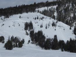
A skier saw a recently triggered large avalanche on a NW aspect of Big Horn Peak in Specimen Creek yesterday (photo). Further to the southwest, Dave and Ian rode around Lionhead and did not see recent avalanches, but did find sugary snow at the ground, some of the weakest they’ve seen. The snow structure is poor (weak snow underlying a dense slab) and triggering an avalanche is still a possibility, although a decreasing one. A few miles north of them in Red Canyon a snowbiker triggered a slide on this layer on Sunday. And on Buck Ridge skiers triggered two avalanches simultaneously that same day (details, photos, and our investigation video). An Instagram post of the avalanche and another with drone footage and a thoughtful analysis offer good lessons on decision-making, terrain choice and stability assessment.
No matter the result, a stability test is never a thumbs-up to go into avalanche terrain. It should only be used to stop us. This may seem counterintuitive, but it’s true. Tests inform us when things are unstable and not the other way around. This is especially relevant this season as weak, sugary facets at the ground (depth hoar) are notorious for avalanching when we do not expect it, hence the title of our latest video, “Low Probability, High Consequences”.
With the snowpack becoming wet, plus a weak layer at the ground and recent avalanches, the danger is rated MODERATE on all slopes.

Yesterday, the mountains around Cooke City stayed cool and wet avalanches were not a hazard. It will be slightly warmer today and a few wet loose slides may release on sunny slopes. As a whole, the snowpack is mostly stable because it lacks widespread weak layers. A person could get unlucky on a slope with thin snow cover where pockets of weak facets could avalanche, or you may find a rogue wind drift to release. Even though we are not expecting avalanches, carry rescue gear and only expose one person at a time on a slope, because sometimes the unexpected happens and being prepared is the difference between a good story and tragedy. In general, it’s unlikely to trigger a slide today and the avalanche danger is rated LOW.
If you get out, please send us your observations no matter how brief. You can submit them via our website, email (mtavalanche@gmail.com), phone (406-587-6984), or Instagram (#gnfacobs).
The Beacon Park at Beall Park in Bozeman is running!
The Friends of the Avalanche Center in partnership with the City of Bozeman put in a Beacon Park at Beall Park. It is located on the north side of the Beall building between N. Bozeman Ave. and the ice rink. Stop by with your avalanche transceiver and do a few practice rescue drills. Your partner will thank you.
Upcoming Avalanche Education and Events
See our education calendar for an up-to-date list of all local classes. Here are a few select upcoming events and opportunities to check out:
Every Saturday in Cooke City, FREE snowpack update and rescue practice at the Round Lake Warming Hut between 10 a.m. and 3 p.m. Poster with More Info.
The video recording of Dave’s recent talk on “Rethinking Avalanche Terrain from a Strategic Perspective” is now available. It’s worth your time to watch it. There is a little something for everyone.